Houston’s weather will remain very fine through about Tuesday of next week. Combined with Wednesday’s cool front, a persistent northerly flow will keep highs in the mid- to upper-80s, and overnight lows in the low 60s for inland areas, and mid- to upper-60s closer to the coast. Drier air will feel great for everyone. We have no significant rain concerns for at least the next week or 10 days. Given this, for the time being, this site will continue to focus on the very active tropics, and specifically the destructive potential of Hurricane Irma.
Irma
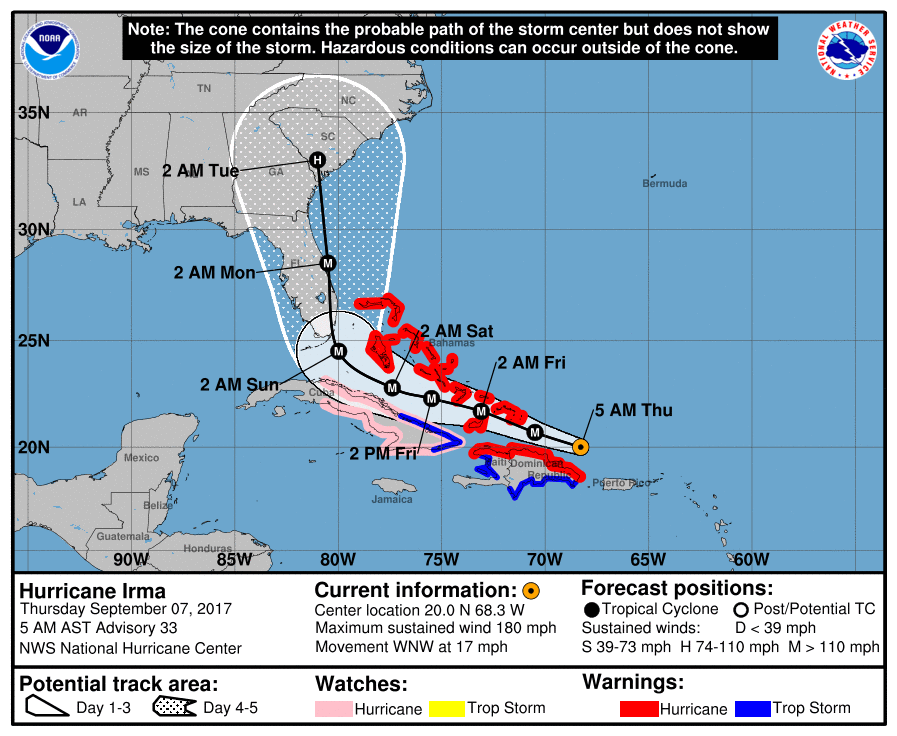
Not a whole lot has changed with regard to the storm, or its potential track, during the overnight hours. The storm has weakened slightly, with a rise in its central pressure, and maximum sustained winds have fallen to 180 mph. Nevertheless, Irma remains an extremely intense and dangerous hurricane. Most of the forecast models bring Irma near Florida in about three days as a Category 4 or Category 5 hurricane, with the National Hurricane Center predicting a powerful storm with 150 mph sustained winds.
In its 4am CT track update (shown below), the National Hurricane Center didn’t change its forecast a whole lot. This keeps the landfall location squarely over Miami, and it’s difficult to argue too much with this forecast. However some uncertainty does remain, which I’ll discuss below.

Intensity
If you look carefully at the forecast map shown above, you’ll see that the northern edge of Cuba lies just within the “cone of uncertainty.” This reflects the fact that most of the ensemble members of the European and GFS model no longer bring the center of Irma over land as it approaches the Straits of Florida, which reduces the chance it will significantly weaken. This is unfortunate for the United States, because it raises our confidence that a large and powerful hurricane will come to Florida.
Track
For reasons previously discussed, the European model is generally superior to other forecast systems, and it has remained consistent over the last three runs with a landfall somewhere along the southern coast of Florida, from the Everglades to Miami. Either is catastrophic for the heavily populated southeastern coast of Florida, from the Keys, to Miami, to West Palm Beach. A more westerly landfall over the Everglades may spare Miami some of the very worst winds (a big maybe), but it would place the storm’s largest surge directly along the heavily populated Florida coastline.
In the model forecast shown above, the ensemble members of the European model show pretty good agreement to Saturday night (position shown just south of Florida). Afterward they diverge, with some members going up the western coast of Florida (about 20 percent), some up the spine of the state (about 50 percent), and some turning north-northeast (about 30 percent), and keeping the center slightly away from Florida over the Atlantic Ocean.
All areas of the southeastern United States, from the Florida Panhandle to the Carolinas, need to brace for Hurricane Irma. If an evacuation order is called for your area, heed it. This is an extremely dangerous storm. It is not a drill. There is still a chance Irma may move to the east of the Florida peninsula (leaving the state on the drier side, with lesser winds and surge)—but a 30 to 40 percent chance is not something I would bet on. I wish I could offer some more hope, but right now the best available evidence suggests this will probably be a historically bad storm for much of the southern half of Florida.
Other tropical systems
You may have noticed that, during the last day or two, both Hurricane Jose and Hurricane Katia have formed. Jose may pose a short-term threat to the northeastern Caribbean Sea—the same area already ravaged by Irma—but I’m hopefully it will remain north of landmasses. Long-term it may pose some kind of a threat to the United States, but again, this scenario seems unlikely. Katia is a threat to the Tampico area of Mexico with heavy winds and inland flooding. No active or forming tropical systems pose any threat to Texas.
We will update again this afternoon. Please the site may undergo 15 to 30 minutes of down time today from 4 to 4:30pm CT due to a server upgrade.
“All areas of the southwestern United States, from the Florida Panhandle to the Carolinas, ”
Did you mean southeastern United States?
Obviously.
I think this was a typo (southwestern vs southeastern). At this time there are no models to support a SouthWestern gulf hit.
What are the chances the high pressure in the gulf of mexico weakens and Katia hangs around and then drifts north
I’m not a meteorologist but I study these systems as a hobby. Katia is progressively tracking towards Mexico and as Eric has said it’s posting a threat for Mexico, not Texas. I honestly wouldn’t be too concerned about Texas at this point in time. At this time all eyes are on Irma.
(northeastern, not northwestern caribbean)
How do we know Katia won’t pull a Harvey?
Let us not forget that when Ike was in the part of its life cycle that Irma is in now, in a quite similar location, virtually all its models also called for it to make the right turn up the east coast. I personally will not exhale until Irma *actually starts turning north*… Ditto Katia. Until it goes onshore and dissipates, I am not relaxing. Look how quickly it went from a disorganized clump of t-storms to nearly Cat 2…
Ike was only forecast to make the right turn when it was well out in the atlantic several days out. When it was near Irma’s current longitude, the forecast was already towards houston.
I agree! In Beaumont and I’m prepared to evacuate of Irma or Katia so much as winks at us.
I think we’re all holding our breath a little here in Texas since we just got hit by Harvey. But the important thing to remember is that none of the models even remotely suggest a Texas/Gulf hit. And as the other poster said, when Ike was at the point Irma was now it was already forecasted for Texas. So do your best to stay positive and not lose your cool. Trust in the models (Especially in the Euro model) and Eric/Matt’s updates. Live in the moment, that’s what’s important.
How are you feeling about Naples on the west coast of Florida? Thank you for continuing to follow the storms.
Also interested in Naples – parents who refuse to evacuate!
Way too early, I’m sure. But I’ll be in NYC for a week starting this Saturday. Even if she makes it there, should I anticipate any issues with staying assuming NYC is on the dirty side? By then, wouldn’t she primarily be a rainmaker and mild wind maker? Thanks for all y’all do. We appreciate it!
Sandy was only a tropical storm when it hit NYC and it was still a huge mess. But with that being said, I think it’s way too early to know if it’ll even come within a hundred miles of us.
Eric, what us your feeling for the this storm dragging up the east coast? Do you think it would impede travels that way mid next week??
Feeling (just slightly, I guess) guilty waking up this morning to gorgeous early September weather. But I did have a question for the science experts. Is there any chance that this overnight cooler temps will help slow down the mosquito onslaught that is inevitable for Houston after Harvey?
With all due respect, with all that’s happened because of Harvey and all that might happen because of Irma, if all you’re worried about is mosquitoes you should feel extremely guilty!!
The mosquitoes make everything worse for all those trying to clean up from Harvey so this is a legitimate questions. Mucking out a house while being eaten alive but those nasty critters is not fun and it would be a joy to hear they may subside a little, so don’t feel guilty Craig!
Buy a sprayer and some of this http://www.domyownpestcontrol.com/pivot-10-igr-concentrate-p-2147.html?rrec=true . It is relatively non toxic and will prevent larva from growing into mosquitos (won’t kill ones already grown). Pretty safe too; the WHO approves the active ingredient’s use in cisterns that contain drinking water. It’s also the same chemical used in a several brands of topical flea treatments. Spray where mosquitos hang out (like bushes wet areas) and it will disrupt the life cycle. Avoid spraying flowers and it is bee safe as well.
I recommend using an insecticide with a low toxicity and with friendly co-formulants but with a wide spectrum of use.
Thanks for bringing your no-nonsense coverage to Irma!
I live in Houston now but grew up in South Florida, where most of my family and friends still live. I’ve sent everyone I know in Irma’s path your website, told them its the only site Houston trusts for weather.
Thanks for the updates as always.
Hope my relatives in Savannah do get out this weekend like they said they would.
The unfortunate timing of Irma following Harvey suggests that remediation services located in Florida are already set up and doing a brisk business in Houston. At least most of the volunteer first response teams and some of the utilities may be able to head that way.
I saw some rescue boats being trailered out of Galveston this morning I assumed on the way to Florida – all those rescue people must be so exhausted Even with bug spray applied 4 times over 2 hours the mosquitoes manage to find a place to bite you – you’re right small annoyance I keep remembering that Harvey was supposed to come here and being very aware that if it had we would all be 6 feet under I am profoundly grateful but mosquitoes still suck – kind of a pun there
I tell everyone about your website and was broken up today that you had changed your prediction on Irma – I am always hopeful but we would have stayed for Harvey and we likely would have died – I hope people evacuate
Eric, I have family in Weston, Orlando, and Tampa.
In the event that this storm goes right through Miami, I know things would be really bad for Weston, but what would be the type of conditions that Orlando could expect and even Tampa that is on the western side of central FL?
Would it still be strong enough to produce Hurricane-line conditions for them or are they looking something more equivalent to a Tropical Storm?
Thanks!
Eric, not exactly the time for this now, but I hope you will address the impact of record warm Atlantic Ocean temperatures on creating and sustaining this record-breaking storm. European scientists in Germany and the U.K. are already attributing the strength of this storm to climate change. At a very basic level (warmer water means more fuel for hurricanes) it seems like a pretty clear link but will be interested to hear your take.
Could you give updates on Jose?