This afternoon I wrote a post for Ars Technica on how confidence in the track forecast for Hurricane Irma is increasing now that we are only about 60 or 70 hours from landfall. Track errors shrink with shorter lead times, and the fact that the official forecast has been so consistent with a likely landfall from the Florida Keys to Miami to West Palm Beach means that there is now a high likelihood in a landfall in one of those locations.
Essentially, this is a worst-case scenario for southern Florida. And this afternoon, the European model forecast had nothing but bad news for the state with the release of its 12z operational run. It made a slight shift west, with a landfall over the Florida Everglades.
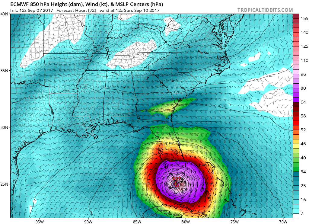
This is really bad, because it not only keeps some of the strongest winds over the Miami region of southeastern Florida, it also pushes a very large storm surge into the beachfront property there. I am running out of words to describe the destructive potential of this storm.

I feel like I have been here before. It was during the 2005 hurricane season, and we were watching Hurricane Rita in the Gulf of Mexico. At about the same point, two to two and a half days from landfall, it was a 180-mph hurricane, and the official forecast track called for a landfall near the southern end of Galveston Island. That night, I despaired. Such a storm making landfall would have pushed a huge surge of water into Galveston and the Houston Ship Channel, and winds would have devastated Houston. (Rita ended up making a pretty sharp turn, toward landfall along the Texas-Louisiana border, and weakening to “only” a 120-mph storm).
This is pretty much where we are with Irma. Right now, along the National Hurricane Center’s forecast track, or the latest European forecast model run shown above, most of southern Florida—including the heavily developed area from Miami to West Palm Beach—will get hit by devastating winds, or storm surge, or both.

There are a few things that could save parts of southern Florida from the worst. Probably the best option (not for the Bahamas, alas) is for Irma to turn north more quickly, keeping the center 30 or more miles off of the Florida Peninsula. I’d give this about a 20 or 25 percent chance of happening (“Saving Florida”). The other saving grace for Florida would be for a more southerly track that takes the center over the mountainous terrain of Cuba, and significantly weakens the storm before bringing it toward southwestern Florida and the unpopulated Everglades area. I’d rate this as a 10 or 15 percent probability (“The Cuban”).
So the chance that southern Florida escapes a catastrophic storm at this point, I’d estimate, is about 30 to 40 percent.
We will update early Friday morning with the latest outlook on the storm.
In addition to the damage to people and cities, I imagine this will be devastating to the Everglades as well.
You’d have to think so.
Eric, what would be the expected conditions in Tamosyif this storm goes straight up through Miami?
and the mangroves, too
Pray for the people of Florida.
My wife and son were able to travel 1.5 hours to College Station to get to higher ground during Harvey. Due to the track of the storm you would almost have to drive like 10 hours if you live in Southern Florida to get out of the way of this storm.
And the freeways have been clogged for days…and a lot of gas stations are out of gas. So yeah…not pretty.
Not really. Winds die off pretty quickly once these storms make landfall. 30 miles inland and on high ground would probably work out fine. At least it did for me, more than once when I lived in Florida.
Oucha….have friends who left homes in Puerto Rico and went to there hi rise in Miami..and now going to Nashville. Sad for their impending losses, but glad they’re wise enough to Go.
Here’s hoping for the swing north.
I hardly think this blog, which is so based in science, is the best place for you to proselytize, Dave.
So we just went through Harvey in Houston and my family has a trip planned to Destin for 1 week arriving on Saturday. Our vacation rental manager is feeling very confident that they will not be affected by Irma. Is there likelihood of Irma impacting the panhandle? Hoping not to go from one hurricane to another. Thanks!
Ask the property manager if they’re planning on staying. Regardless of the answer, I wouldn’t go.
The storm is huge. I don’t think there’s any chance of the storm NOT impacting Destin to some degree. Obviously the more easterly track the better, but all of these scenarios still involve at least a couple nasty days for Destin.
Can you push back your arrival to Monday and then wait til then to see how badly Destin is hit?
I just flew into Houston this afternoon from the Destin area. I would cancel if I were you … you never know how these storms will turn (people in the Destin area say Ivan’s path was similar and made a turn into the Gulf)
Lauren, my girlfriends and I are also supposed to go to Destin next week. I’m in the firm nope camp since we just experienced Harvey and I’m still having PTSD.
I lived in West Palm Beach, this track is the one they’ve always worried about in Florida a powerful north-south hurricane basically traversing the entire peninsula. This is going to be beyond catastrophic for that region.
Eric, your reasoned analysis and easy to understand breakdown of things has made you one of my favorite Ars Technica writers. I’m dreading what Irma will do to my family’s region of Florida (the northeast, between Jax and Daytona). My town was devastated by Matthew last year, so I’m afraid of what’ll happen in a going-up-the-east track because the storm surge shattered A1A and damaged the piers and the beachfront, and Irma’s surge will be even more horrific, I fear. I’ve been trying to follow the track and not fall to the hype, and so your site is an invaluable resource for me right now. Thank you.
I Think IRMA & JOSE Are Interacting:
The Fujiwara Effect
Rotating Cyclonically Around Each
Other Just Enough To Keep IRMA
From Turning Northward As It Moves
Westward Along The South Side Of
The High Pressure Ridge
Steve, unless you are a meteorologist and/or have access to multi-million dollar super computer clusters with the expertise to analyze massive amounts of data in realtime you should really let the meteorologists do their job. Fujiwara is not common and there’s been no mention of it so far. If it were a concern it would be mentioned.
Record hot oceans mean record strong hurricanes. Welcome to the new normal.
What a difference 1.53 degrees makes!
What do you think the panhandle should expect to see?
Thank you for keeping us posted. After all this you deserve a few weeks vacation. You are always such a lifesaver with your reasoned analyses.
Can you comment on the Destin area? I assume it will get mostly rain but how much/bad?
What are the predictions for the other coasts along the Atlantic? I have family who live on the Georgia coast and I can’t find ANYTHING talking about the impact of areas outside of Georgia.
85 year old father in Destin and is oblivious to the danger. I am in the Houston area and getting him out would not be easy at this time but, Eric, if you say to to go, I will! What do you say?
Thanks so much! I appreciated your Harvey coverage, now worried about Irma. How about the other Space city, Kennedy Space Center, Cocoa Beach? It avoided a direct hit with Mathew last year at the last moment.
KSC is shutting down tomorrow although I’m sure there will be a ride-out crew. They’re taking it seriously and want their personnel to be safe.
How is this looking for Tampa? Should people there stay put (assuming adequate supplies)?
I evacuated during Rita from Houston and spent today traveling with my family from Sarasota FL north towards Tallahassee – it felt very much like Rita (lots of traffic, searching for gas, everyone exhausted and slightly panicked). We will go on to Atlanta tomorrow. Irma, please keep heading East!!
Question…could tsunamis in Mexico pull Irma more west?
Could you address the die-off of wind speed once she hits a land mass NOT a flat island?
And is that why winds were SO damaging even to concrete bldgs on the islands?
All eyes on are on Irma. As Eric has said the next 10 days look good for us in Texas. Let’s focus on the major stuff, not the rain for West Houston.
I livw 40 minutes outside of New York City and discovered your website during Hurricane Harvey. I have been transfixed ever since by the “calmness” of your forecasts.(Remember I’m from NY and am used to more frantic tones.) Your explanations of what is really going on are so concise as are your descriptions of how various hurricanes act.
I plan to continue reading your site for a long time and thanks for using the the word “truthfully” so much.
do you think IRMA will not turn north and continue heading west
What are the chances that IRMA continues on it’s western track and misses Florida all together?
Do you think it could travel on Katrina’s course?
Don’t be scared of a little wins and rain. I live I South Florida and I’ll I’m doing is loading up on weed and liquor and rolling fat boys and turning up that good good. If I get in trouble someone will save me