Hurricane Irma remains a large, extremely powerful, and dangerous hurricane this afternoon. As one of the forecasters with the National Hurricane Center, Eric Blake noted on Twitter, “Irma has now maintained 185 mph winds for 24 hours—no Atlantic or eastern Pacific hurricane has ever stayed this strong for so long.”
Truthfully, not a whole lot has changed from this morning’s forecast, when we noted the eastern shift in some of the forecast models that kept the center of Irma east of Florida. But not the most important ones. The European and GFS models are definitely not on board with such a solution.
Before jumping into the forecast, here’s the most important message for South Florida residents with regard to Irma: A catastrophic hurricane may approach your location later on Saturday night or Sunday. The time for making final preparations is now. If an evacuation is called for your area, go. If you live in the greater Miami area, what we can confidently say from the modeling data is that there is a reasonable chance—perhaps 50 percent—that catastrophic winds are coming to one of the wealthiest, most well-developed coastlines of the country.
From the forecast perspective, the basic reality is that we aren’t much closer to understanding the ultimate track of Irma this afternoon than we were on Tuesday. If you’ve read this site for any amount of time, you know I like to use ensemble forecasting from the global models to make predictions—this is because ensembles offer a reasonable range of likely outcomes for a given weather event. And in looking at the most recent ensemble runs of the GFS and European models on Wednesday afternoon, there really hasn’t been much of a narrowing in Irma’s likely track this weekend.
First, the GFS model:
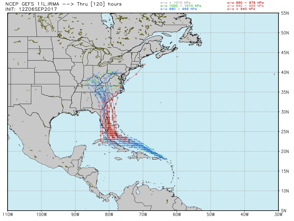
Now there isn’t much clarity here, but the model does seem to be centered upon a track that will bring Irma into the Florida peninsula, or just east of the state. (Obviously the intensity of Irma when it reaches Florida is dependent upon the extent to which the storm traverses Cuba beforehand).

Now let’s look at the 12z European model ensembles. There is even less clarity here.
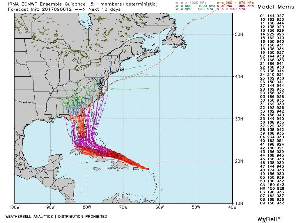
There is a message in this plot. And it is this. The best forecast model in the world, bar none, is struggling mightily with how to handle the track of Irma in about three to four days time. About 30 percent of the ensemble members bring Irma across Cuba and into the eastern Gulf of Mexico, about 40 percent bring the storm into southern Florida, and about 30 percent keep it off the east coast of Florida.
Do you know what that means? It means we are no closer to having a great handle on where Irma is going to go this weekend. Almost certainly, the storm is going to bring catastrophic wind and storm surge to the Florida Keys, greater Miami area, or the Bahamas—and perhaps two of these three areas depending on the final track. But don’t believe anyone who tells you exactly where. Because if the European model doesn’t know (and the GFS model is struggling, too), then we’re all in the dark.
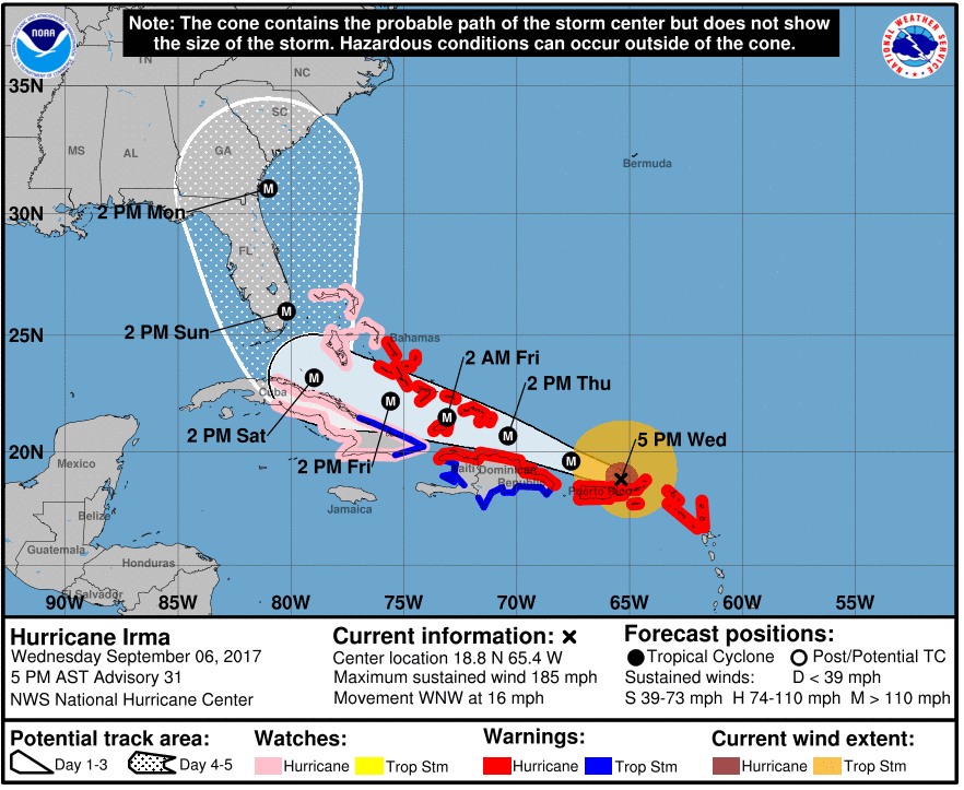
Hence, my initial message to people in Florida offered above: A catastrophic hurricane may approach your location later on Saturday night or Sunday. In this case the “cone of uncertainty” in the National Hurricane Center’s 4pm CT update really is accurate. The storm could go anywhere in there.
We’ll have a new post early Thursday morning, when hopefully the forecast models are a wee bit more helpful.
Hi, Eric.
Thanks for all that you do. I have a question for you simply out of curiosity:
I noticed that this massive storm is passing near Puerto Rico now and the wind gusts are “only” in the 50’s. Is that the strongest the winds are going to get there?
If so, I’m certainly happy for them but I’m struggling to understand how a CAT 5 hurricane so close to them would produce those types of winds and we got even stronger gusts in some areas of the Houston metro area from what was essentially a weakening Tropical Storm.
I’m just curious, how is it that a much lesser storm affected us worse from a wind standpoint than Irma is doing to PR? Thanks!
Hurricane force winds do not extend far from the eye. Most of Puerto Rico will also be on the relatively weak side, it seems. Here’s wind probability graphic from the National Hurricane Center:
http://www.nhc.noaa.gov/refresh/graphics_at1+shtml/210044.shtml?hwind120#wcontents
If the eye of the storm passed north of their island then they were in the “slower” wind side of the storm. The winds on that side are flowing opposite of the storms direction of movement and therefore cancel each other…somewhat.
Figure out the math, gusts over 100 mph. red lines means powerful high winds, and the angles thereof. That is where you dig out your protractor from school and line up the angles, add them all up, and divide them by three. Don’t forget the winds are measured into thousands. Wind volucity.
I’m in zephyrhills Florida is it gonna hit there no one is telling us its Pasco county
I live in Houston and have family & friends on the southeast coast of Florida. So grateful for your measured and honest forecasting through both these hurricanes.
Time for South Floridians to board up and get prepared to move out.
I have friends in Florida and I appreciate these as accurate as can be reports.
Thank you for covering this. My brother-in-law’s family just moved to Orlando about a year ago from Houston, so we’re keeping a close eye on Irma as well. I trust your input on storm tracking over any other source.
Thank you for all that you guys have done to track this storm. After Harvey, I’m sure I’m not alone in wanting to urge friends and family in FL to seek shelter elsewhere. You’re cautious approach and informative nature is much appreciated.
Eric, It was my understanding that a storm cannot remain at a Cat 5 intensity for very long – like 24 hours or less. Apparently that is not true with this hurricane.
But is it true that a storm become unstable and looses strength at these high wind speeds after some time? Is there a scientific explanation for this?
Generally the very strongest storms fluctuate over time due to eyewall replacement cycles. Not sure why we’re not seeing this right now.
Is this year seeing a science based trend toward bigger storms or are we just over sensitized because of Harvey?
Were I in Florida, I’d be boarding up today, and bugging out tomorrow. Even with these divergent models, the risk/reward of staying would be too bad in my mind.
Agreed. Going to be bad, regardless. Potentially catastrophic.
Eric, if you were me and have parents in West Palm Beach and a sister and her family in Miami, all of whom I have practically begged to get out and come stay with me (in Pearland), at least until Irma passes and the power gets turned back on in their houses – if you were me, what would you be telling them about risks of staying vs. driving?
Thanks again Eric for your insight and expertise. While I think we can all safely say this won’t hit Texas, my thoughts are with those in its path. We just went through Harvey in Texas and it was absolute hell. I wouldn’t wish one of these monsters on my worst enemy. I have 2 employees in FL so I’ve bought them plane tickets for them and their families to come to Texas and work starting tomorrow. Better safe than sorry. But definitely the Southeast Gulf to the East coast needs to prepare. Even at a cat 3 it’s pretty significant.
Eric, Thanks for the Florida update. I have friends living in Orlando and will forward your site to them.
Also, Thanks for the excellent coverage of Harvey. Looked forward to your update first everyday during the storm.
Keep up the good work. Lots rely on your expertise.
Mike.
This is more or less what I told my mom, who is in Palm Beach County. Don’t panic, have your supplies handy (she does), and don’t watch the weather channel.
Thank you Eric! I have family in Miami and I look forward to these updates as well!
I’ll forward them your site! Thanks for all you and Matt do!
We live In Jacksonville, about 40 miles inland, we are definitely keeping an eye on this monster. Stocked up, gas, etc. I think the uncertainty of where Irma is headed is what is causing the panic. We are ready to evac to GA if necessary, will make that decision on Sat.
If I had family in Miami, West Palm, Melbourne, and points in between. I would be strongly urging them to move as Far North and West as possible. Stay safe Floridians. Thanks for the updates.
Eric – You have “Harvey on the Brain” again. Check the GFS forecast graphic.
Honestly, with a storm this large and powerful, how much does the exact path matter? Heaviest damage will occur along the eye path, but all of south Florida is likely to see tropical-storm-force winds.