POSTED AT 8:30 PM CT TUESDAY: Good evening, and we come to you with some positive news for once, at least as it relates to Houston.
In a nutshell, we have a growing consensus for Laura to make landfall far enough east of Houston to likely spare us really bad impacts. Just to be clear, you should still be heeding the advice of local officials, and you should remain vigilant in case something changes at the last minute. But from all we’ve seen today, we feel good about our position here in Houston.
The biggest challenge for us in forecasting Laura’s potential impact in Houston has been dealing with the European model and, in particular its ensembles. The overnight run of the Euro (ECMWF) and its ensembles continued stubbornly pushing Laura’s track west to the point that I’ll be honest: I woke up by chance at 3 AM, decided like a good meteorologist and foolish human being to look at my phone to see how the model finished, and basically woke my wife up by belching out an expletive. It had precedent. The Euro had been consistently on the left side of guidance (farther south), and every updated forecast point was coming in south of even that guidance.
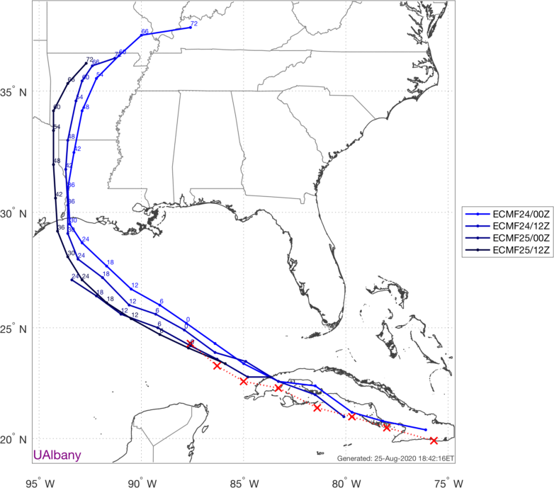
And since the Euro is generally considered our best performing model, you have to at least grant that some credibility. All along, the models we use specifically for tropical storms and hurricanes have been consistently focused on the Texas/Louisiana border or into southwest Louisiana. Well, wouldn’t you know it but now those verification points above are coming in north of forecast.
Getting questions about track trends/wobbles re: #Laura and #HOUwx implications.
Hurricanes wobble all the time, as you can see by plotting the estimated center each hour from 1-7 PM CDT.
That said, the center is consistently a hair N of EPS forecasts. pic.twitter.com/kzuwTaU11I
— Jack Sillin (@JackSillin) August 26, 2020
In fact, the 18z European operational model takes Laura just over the Louisiana side of the border, in line with tropical models
What does this mean? It means the folks at the National Hurricane Center are pretty <redacted> good at what they do. The latest forecast track for Laura takes the center ashore near the Texas/Louisiana border tomorrow night as a major hurricane.
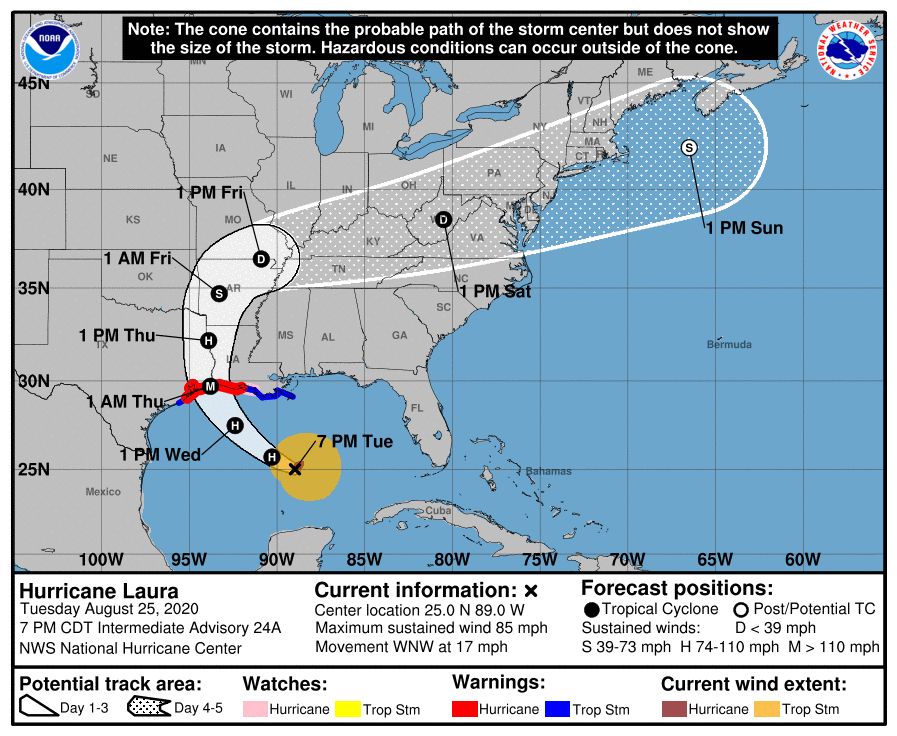
For us in Houston this explicitly would mean primarily tropical storm impacts instead of hurricane impacts, as tropical storm force winds do extend out over 175 miles east of the center (it will be less to the west). At the coast, that could be different, with slightly stronger wind (perhaps close to hurricane force) and a storm surge of 3 to 5 feet in Galveston to upwards of 6 to 9 feet across the Bolivar Peninsula to High Island.
The caveat to all this? Hurricanes do tend to wobble sometimes. In most cases, the wobbles average themselves out and cancel out. But at times some more distinctive wobbles could yield a track farther southwest or northeast. We will monitor that tonight and tomorrow to see if there are any trends that stand out. This is why it’s important to remain vigilant. We look fortunate now in Houston, but things can sometimes change quickly.
In case you wanted a look at Laura on satellite this evening, here you go.
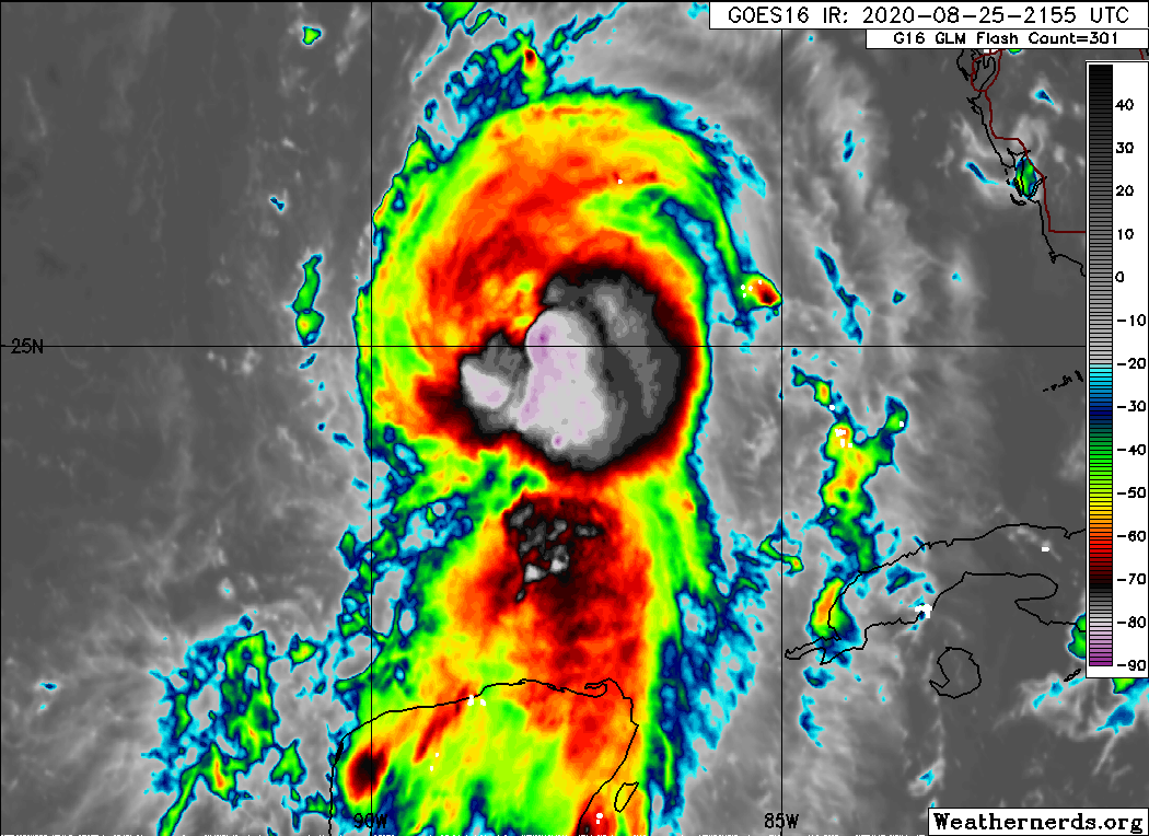
This is a much healthier looking storm than even 6 hours ago, so we’re likely heading for some impressive strengthening tonight.
While we’re very positive on Houston at the moment, I personally can’t help but feel some sense of despair for folks in the Golden Triangle and southwest Louisiana who have been through the ringer over the last 15 years between Rita, Ike, Harvey, Imelda, and now Laura. Unfortunately, Laura’s storm surge impact into extreme east Texas and southwest Louisiana looks very serious.
Here's the latest ADCIRC estimate of water inundation depth as of 5PM ET (Aug 25). Shows 10+ feet near the landfall spot & feet of water nearing Lake Charles. This could be one of the worst U.S. surge events in recent memory. FYI: 90% of hurricane deaths are due to water. #Laura pic.twitter.com/15wgIOTP4x
— Steve Bowen (@SteveBowenWx) August 26, 2020
While the Houston area gets a lot of air time because we’re the 4th largest city in the country, the folks in Beaumont, Port Arthur, and Lake Charles are sometimes overlooked. So if Laura does indeed spare Houston, we hope we can pay it forward in some way to our neighbors to the east.
Eric will have our next post up no later than 7:30 AM CT Wednesday.
Thanks for the timely update guys. No celebration here in HTX both bc of the uncertainty and bc of what this means for the folks east of us.
Indeed. Let us not forget all the people who came to help us in Houston after Harvey. We need to return the favor when the time comes.
100% agree!
Good news indeed for Houston area. We’ll all have to watch the wobbles – look forward to morning and mid-day updates.
I personally cannot thank the two of you enough for your diligence and apparently all night watching of the system. I too am guilty of waking at 3am (very common occurrence for me) and I also check the models (tropical tidbits). So, I know exactly how you must have felt and got a chuckle out of your “expletive” statement!
That said, I am now going to check on my friend in Beaumont………….
Thanks. What likelihood would you give chances the storm shifts West again? You said it can change, but what is the likelihood?
It seems that whatever weather Houston gets, poor Beaumont gets it three times worse.
Great work, thanks! (wringer, btw)
Completely second your sentiment on East Texas and Louisiana.
I appreciate you mention Beaumont, Port Arthur, Lake Charles~ but don’t forget Orange! 🙂 Y’alls respires are the best. I’m in Houston, grew up in Orange and that’s where family still is. All of which have suffered all named storms above!
REPORTS! Not respires!
That’s mighty petty for what it sounds like her family is going through. Poor form on your part.
Rob, she corrected herself. The Space City weather guys did not. Just wanted you to know so you didn’t think they were jerks!
Thanks for the updates. By far the most detailed and thorough posts of any weather site I’ve ever seen! Do all the hard work and summarize it for everyone not as knowledgeable as yourselves
Thanks for the added humor. It’s much needed! <3
Thanks again for looking our for the great folks east of us, Matt.
Praise Jesus for Eric and Matt! They were both sent by God to keep us safe!
That’s a stretch
Appreciate the diligence and writing style of you both. You’re unparalleled in the Houston area for making complicated weather patterns understandable to those of us who find these conditions so worrisome.
Should we expect severe power outages within the city? Having been through Ike and Harvey I’m not really sure what to expect with TS winds!
I’m with you on feeling bad for the folks east of us. I’ve spent some time way south in Louisiana, Houma, and even Dulac. Storm surge there is a monster problem, as is wind and rain. If we’re spared keep those folks in your thoughts. They’re gonna need it.
Thanks for the updates, the best weather site and meteorologists in the world as far as I am concerned. My go to when it comes to tropical weather. And yes, the Golden Triangle people and into Louisiana have been hit time and time again and if this is yet another time we all need to step up and see what we can do to help those fine folks out.
You and Eric have done a stellar job, Matt. Thanks for all you do. I know you have a lot of faith in the Euro, but I’ve seen it perform like this on winter storm events, too. Holds on until the last few hours, then comes in line with other models. Still, quite reliable, though. – Sid Sperry – The SPIA Index (Go Yankees…)
I would really appreciate a forecast of Laura’s impact to the west of its course. Will it blow down trees and power lines or just be noisy? I need to decide if I evacuate or not.
If you lose power consider evacuating. Before the storm just be prepared
Thank you for the great coverage. I hope the best for us but I appreciate your empathy for our Texas and LA neighbors to the east
Prayers for our folks to the east. Lived in the Beaumont area for may years. Came back to Houston to night to secure house in the event that Laura would lean west.
My heart goes out to the people in the Golden Triangle and Southwest Louisiana. Let’s not forget how indispensable they were when we were devastated by Harvey. Let’s help out all we can ((
thank you so much for all your spot on reporting. you guys are great!!!
Eric and Matt, I started following you gents during Harvey. I appreciate all the daily emails about your weather forecast and the multiple forecasts when we have a storm coming like this one. While I am grateful the hurricane seems to be moving east, I couldn’t agree with you more – my heart goes out to the folks who will receive the brunt of it…another hurricane and flooding is the last thing anyone or a business needs on top of everything that has happened thus far in 2020.
I’m thinking I’ll sleep better tonight than the last two – out of fatigue if nothing else.
My thoughts are definitely with the good folks in the Golden Triangle and Lake Charles area. I have coworkers in both.
Absolutely great job guys. Love to read your reports and reasoning behind the how and why. I also woke up at 3:30 this morning and spouted off a couple of choice words in the process at seeing the Euro model pushed into Galveston Bay. Obviously you never know with these systems how they will be until they are over. Thanks a bunch for the info.
As a Beaumont native and current resident I appreciate y’all including us in your forecast. Your post are so informative without the hype and drama. Prayers for everyone in harms way!
Thanks for the update but heartbreaking for east Texas and western Louisiana. With Covid, what is the best way to help out?
Donate money to reputable aid organizations who are experienced with both immediate disaster relief and longer-term disaster recovery work.
These organizations have way more resources at hand than small orgs, and even the Cajun Navy, astounding as it was, was limited in what they could do. Your cash dollar will go way further with one of these aid orgs than on your own.
I generally give to the Houston Food Bank, who are the big distribution hub for the whole coastal bend.
Adding a bit more—once the immediate danger has passed, look for LOCAL organizations in the affected areas and ask what they need. They will have a good understanding of requirements and they may not match your expectations…as in, it might feel good for you to send clothes, but what people living there really need is a flatbed truck covered in round hay bales so their stock survive the winter, or money to pay for funeral expenses.
Ask and follow their guidance.
Been waiting for your evening post and glad to see it. Thanks for responsibly reporting on this and all severe weather events. It is much appreciated.
I read your entries with admiration and gratitude.
why does it seem that storms always come onshore at night? every memory i have of a hurricane impacting the houston area from alicia onwards is the landfall at night (and trying to sleep in some uncomfortable-but-safer place in the house).
thanks so much for being my favorite weather nerds!
All experience but zero science to back it up. I wanna think that the storms come onshore at night because they are constantly looking for warm water, and my best observation is they always look for bays and harbors to make landfall, they find water until the run out, like a billiard table.
Prayers go out to my brothers and sisters in East Texas and Western Louisiana.
I experienced Charley in 2004, and she took an unprecedented turn 12 hours before landfall.
Are there any remarkable similarities at this point?
Danny Kiper
I want to know how far north is in great danger also after landfall
Thank you for such great reports. I’m riding out the storm in Port Neches, Texas. Last fall, the TPC explosion blew me out of my chair, now praying Laura doesn’t do the same! Lol
Thank you for your hard work and regular updates. And, yes, I’m quite worried for our fellow Texans in places like Orange, Beaumont, Winnie, Port Arthur and other towns and communities at high risk, as well as our neighbors in Louisianna.
Even so, I don’t trust hurricanes as far as I could throw one. I won’t be certain about this storm until it is too late for it to turn even an inch. Paranoid much? Yep. Been through too many for my taste: Carla, Alicia, Ike, Harvey and the many tropical storms that have tried to drown us out. And, Carla is just the first one I actually remember. I was a mere child when she struck.
But, again thanks for your efforts.
Great job as always guys. Prayers to the folks in SW Louisiana. Will be looking for ways to help.