POSTED AT 2:25 PM CT TUESDAY: Ok, everybody. We understand. You’re sick of reading about Hurricane Laura, and trust us, we’re tired of writing about it. (We first mentioned the possibility of Marco and Laura way back on August 16, which seems like several lifetimes ago). So this afternoon, if I can offer one piece of good news, it’s this: Forecast models are starting to cluster a bit more, so confidence in the track is increasing. By tomorrow morning we should probably have it pretty well nailed down. And then by Thursday afternoon it should be all over as Laura pulls away. So in two days we’ll either be starting the clean-up process, or looking to help our friends to the east, in the Beaumont area and Southwestern Louisiana. The unnerving uncertainty, at least, will end.
Track
We’ve had a new suite of model guidance come in today, and the big news is that the operational run of the European model has shifted east a bit, bringing it closer in line with the GFS global model, as well as the National Hurricane Center forecast. This is the kind of clustering we would hope to see at this point to increase confidence in a track forecast. Under this scenario, Laura would make landfall near the Texas-Louisiana border, or 10-20 miles west of there, late Wednesday or early Thursday. Along this track, Houston would very narrowly escape the worst of Laura’s winds, waves, and rains—these would impact Beaumont, Port Arthur, and Southwestern Louisiana. This means the most likely scenario is now an event similar to Hurricane Rita, in 2005.
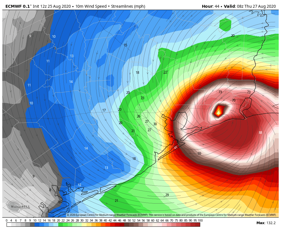
However, and this is very important, this track is far from dialed in. There are still some models that dissent from this scenario, and there remains the potential for Laura to wobble as it moves across the Gulf of Mexico. I think we can safely rule out a landfall near Freeport or the San Luis Pass, which would be the absolute worst case scenario for Houston and Galveston. However, a landfall anywhere from the East End of Galveston Island to the Texas-Louisiana border remains in play. Believe me, I would love nothing more than to close the book on Laura, but we are just not there yet. Maybe by tomorrow morning, maybe not. This is a nail-biter for the Houston and Galveston areas. Please heed mandatory evacuation orders and continue preparations.
Intensity
This remains a very difficult forecast. We have seen little strengthening of Laura through the early afternoon hours, but that’s to be expected. The National Hurricane Center anticipates the storm will undergo most intensification between this evening and Thursday morning. They’re predicting Laura will come ashore as Category 3 hurricane, and that seems reasonable, plus or minus a Category. Strong winds will likely begin reaching the coast by around 6pm CT Wednesday.
Laura should be a large and powerful hurricane at landfall, and it will cause widespread damage. Given the potential for further, modest swings in the track, we’re asking you to hang with us for another day or so. We’ve just really got to keep tabs on this one, Houston.
Matt will have our next update at 8:30 pm CT, or a bit earlier.

Waiting another six hours for a post…hanging on every word. Thanks for all you do Matt and Eric.
Thanks for all the concise insight!
We are thankful for your attention to our ability to make safe and sound decisions. As always you are putting getting it right as most important.
Thanks for all you do. I wait for each update….
Appreciate you guys!!
We aren’t sick of hearing about it. I check often to see if y’all have any new info. Y’all are the best!
Same here, Matt and Eric. Looking forward to your updates! You all are amazing at what you do. Thanks! 🙂
Thank you!
Eric,
If you follow TWC’s track, the storm has been heading significantly more northwest than west, and it seems the models keep wanting it to go west but in reality it has been tracking more north. Very strange discrepancy
First
Not even close
Keep the faith Eric! You and Matt are doing a great job. Speaking for myself your forecasts and hurricane info is the only one I need.
Those of us all over the country have learned about your expertise after mentally riding out prior Houston storms like Harvey. We depend on you to inform us about what our family and friends are facing. Thanks from Florida.
We aren’t sick of it, you guys are helping me prepare and getting me through the day! I haven’t taken a single glance at the news stations, that is how confident I am in your reporting. Thank you for hanging in with US!
Thank you for everything y’all do.
ugh, I don’t have the strength for this year anymore.
I just want to lay down outside and let this thing blow me away and be done with it
That’s called the “Lieutenant Dan” approach to hurricane preparedness. Worked out ok for him…
I could use some primal scream therapy tonight myself. Anything available online?
What are the rain chances inches wise for Houston
I believe they’ve said that if Laura does make landfall around the TX-LA border, that we should get 1-3 inches. It’s expected to move and keep moving, not stall out.
Thank you, Matt and Eric!!!
Count me in as another who relies on your calm, rational updates. Thank you Eric and Matt, so much!
I could hardly wait for this post! lol Seriously, I really appreciate your dedication and honesty. I like to know what to expect. You guys are such a blessing to me.
Space City Weather is the best!!!
I am so glad that you all are giving us the straight up information that we need to actually make decisions. Some of the other sensationalistic reports make it so that no one can make a good decision. While I’m sick of the storms I’m not sick of you all speaking about them and doing what you do great.
I live in Brazoria near Freeport, super appreciate you giving visibility to what outer Houston areas should expect.
Is it possible to predict what wind speeds we might expect in Spring, TX? Trying to decide whether to evacuate my handicapped mom.
I don’t even pretend to be a weatherman, but from the map and the current speculation of that colored map on wind speeds, and the current projected path:
it looks like wind speeds in Spring less than 30 mph, except for gusts
how often does the power go out from thunderstorm winds where your Mom lives
If #2 is “a lot”, maybe move her from where she is. If “hardly ever” then maybe leave her where she is.
I second (third?) that we are not sick of hearing from you. I am dialed in for every update right at the time you promise to post it. If you wanted to post info more frequently, I’d be locked in for that too. Thanks for the detailed, rational, and practically useful advice.
Thanks so much. Been following you (and now Matt) since Katrina/Rita. I don’t even watch the news anymore. Totally appreciate your honesty when you are unsure. You still deliver the facts and your thoughts. You guys are essential!
Thanks, Eric and Matt: We evacuated from Clear Lake to Waco and will be glad we did so regardless of where the storm ultimately comes ashore. Thanks again for your honesty and always excellent analysis. Chuck S
Taking a boarding up break, happy to see the news isn’t worse, wanting to buy Eric and Matt all the beer (or any other beverage you want) when we can celebrate again.
Was waiting for your post. Now i can breathe a little easier. Thanks for ypour honest and straight forward posts. God
bless you all.
As always, appreciate the thoughtful update.
I was at Home Depot earlier, and good half-dozen folks had carts with Ryobi 6500 watt generators. I think part of the purchase decision is a kind of magical thinking – maybe if I’m prepared, that would psychically make the storm miss us. I can’t blame them – I stocked up on propane cylinders for the gas stove I bought 8 years ago and never used. 🙂
My generator is still sealed in the box. Every year I fill the red gas containers to ward off the storms. Then I put the gas in the cars once the season ends.
Here’s to hoping my voodoo remains strong!
Can you move next door to me? Thanks.
The generator worked wonders for Ike. We were one of few houses on our block that had power, even AC for days. I’m in the far northwest Houston. If a power line is knocked out, having one night of AC and no spoiled food in our refrigerators is worth it for me. Never once lost gas or water. We got charcoal and matches to grill meat!
Are there any more storms or disturbances that are waiting in line out there in the ocean?
Add me to the chorus of thanking Eric and Matt for these updates. I don’t bother turning on the TV weather-yellers (TM) with their screeching. No need for that literal noise.
This site provides solid, no-hype updates and that’s all you really need. I don’t need an update every 5 minutes since that just means that this is for more room for hyperbole.
Thank you for keeping us informed and being so forthcoming.
Y’all are the best. I followed this site while living out of state during Harvey, and now that I live here, am a daily checker, and have gotten family on it as well. Thank you both for all you do; y’all (and HEB) are a huge part of what makes this city great. Houston Strong!
Can you predict when the locusts will arrive? I’m done with 2020.
How much of Texas will see rain from Laura? I’m 73 miles west of Houston in Colorado County. Will we see any rain or windy conditions? Trying to get my Houston and Pearland kids to come here ASAP.
BJ, you just want your kids to come visit, dontcha??? LOL.
Any chance of this storm moving West enough so that Houston ends up on the dirty side?
Did you read the update?
“I think we can safely rule out a landfall near Freeport or the San Luis Pass, which would be the absolute worst case scenario for Houston and Galveston.”
They’ve basically already said they don’t think it will go west of Galveston Island.
I live in Katy – should we be ok here? Or would it be best to evacuate? I see a lot of my neighbors starting to load up their SUVs.
I will you give my opinion on leaving based on living here my whole life. Those further inland will not get the brunt of the storm winds or the water surges on a hurricane. What poses a threat to you are tornadoes or flooding. The flooding has to do with drainage systems in your area and how much rain the storm dumps. Harvey stalled, thus the massive flooding. You should know how your neighborhood floods in heavy rains. They usually damage roofs, take down fences, and weed out weaker trees. As to tornadoes, those are smaller than we see like in Kansas but there are many more of them. Those cannot be predicted and thus you can’t run from them. Leaving does not change that as the storm travels on inland. I knew someone who fled in Ike to east Texas from the coastal area. The home they took refuge in got a big tree plopped down on top of it. The home they ran from was just fine. So what you need to do is seriously evaluate the refuge shelter you stay in. If in a mobile home, leave it. If your home is solid built and not prone to flooding, that’s your best option.
Oh no….don’t tempt us 😃😃 (to relive an old joke)….
Seriously, you should be fine. I’m in Clear Lake and almost all of us are staying. Only my neighbor is boarding up (I have laminated windows and roll-down shutters).
Eric and Matt, thanks for the no-hype advisories. 🙂 As Yogi Berra said, “It’s tough to make predictions, especially about the future.” 🙂 Throw in the vagaries of “Mother Nature,” and that explains the whole hurricane forecasting uncertainty. Unlike you guys, a well-known local newspaper in an email yesterday already mentioned a Cat 4 storm hitting Houston. Totally irresponsible fear-mongering. That type of nonsense, and generally bad reporting elsewhere made me cancel that subscription years ago. Wonder where they got their superior “data,” a “Magic 8-Ball?”
Everyone remember, if the water supply gets affected , if you have a tank-type water heater, the volume of water in the tank is treated, safe to drink. Just close off the inlet, turn the heat source off, don’t use it for showers or baths.
Clean out a bathtub or 2 and fill with water for washcloth baths outside the tub. The tub water also is used for flushing toilets. You also can treat the tub water with 10-20 drops of plain, unscented chlorine bleach per gallon of water. Might not taste like Evian, but it too would be safe to drink.
Hope this misses us, but I’m 90 miles off the coast and began preparing last week when you guys said to think about doing so.
thanks guys. much appreciated
I’m not tired of reading about it! The updates are super helpful!
Thank you so much for your hard work! I still remember reading you, post after post in the middle of the night with Harvey… each of your predictions becoming a reality. Thank you for keeping us informed. Forever grateful!
With the wind threat should we be considering boarding up windows if we are in the Pearland area?
We are heading to Tyler. Is that a knot enough out of way
With our gratitude for your frequent and detail-filled updates!! Our family from away follows along here too!! We appreciate your efforts and voice of reason!!
Eric and Matt,
As always, thank you for your concise explanations and words of encouragement. As we all get ready, please take the time to prepare yourselves and get some rest (yeah like any of us are until Friday) to prepare for tomorrow and Thursday.
Interesting that the Marco swirl is still visible on the satellite loops.
Thank you.
Hey there. Question about the Euro map. I noticed that you switched from this morning’s HWRF.
How much of the realignment is due to what the models have been outputting and how much is due to Laura’s wobble?
Thanks for your great work. Keep it up.
Not sick of hearing about it at all, guys. Hanging on every post. Keep em coming please.
Thank you for all your hard work and excellent forecasting!
Rita blew even into northeast Texas. Would we expect that?
Yes. If you are going to run, you should run an opposite direction than the predicted path.
Thank you, gentlemen!! Many have faith in your good work.
Eric and Matt,
Thank you! Now what can you do about this COVID crap? You guys are super heroes for sure!
I know so much is still uncertain, but could you give me at least an idea about what type of wind and rain in the New Caney/East Montgonery County area (near Grand Pkwy @59 area)? I know people in mobile homes there, and they’re concerned. Thanks!
Tired of hearing about it?? That’s what we’re here for!
Found you guys (a little too late, unfortunately) right before harvey. We were some of the unfortunate folks in katy who had never flooded and got totally drowned by the post-harvey releases… anyway!! You guys give me much needed peace of mind during all of this chaos because I can count on you to not sling sensational, panic inducing language around silly nilly. While I find myself dismissing local broadcast weather forecasters because every single thunderstorm sounds CATASTROPHIC, I check back in on this website throughout the day And actually heed your advice. We packed up and are already settled out of town because we’d rather waste a trip and see family and have nothing happen at home than wait and be stuck in 12-24 hours of gridlock to get anywhere later… or be stuck without power indefinitely.
All of this to say a simple thank you!! No pressure or anything, but there’s a whole lot of us who rely on you guys and your cool, calm, and collected approach to all this! We know it can’t be easy; Texas weather is more indecisive than my kindergartner talking about her next birthday party theme (she’s currently set on having a surprise party. Sounds a little like hurricane laura, to me!).
Thanks. Just thanks.
Thank you for all of your excellent information. We’ve been preparing since last week as you advised. Anxiously awaiting your next update!
Thanks for your update. I check frequently to see if you have posted a new status updat