Houston has about two more months to go, in terms of prime time, for the 2020 Atlantic Hurricane Season. As long time readers of this site will know, the odds of Texas being hit by a hurricane after September 24th, are quite low. By all appearances, the next two months in the tropics will be quite busy, with the Atlantic’s Main Development Region already starting to heat up. So we are going to have plenty of systems to monitor. To survive this period of anxiety, therefore, we should prioritize which tropical systems are worth worrying about.
And we’re here to tell you, Houston, Tropical Depression Eight does not have the look of something we think the greater Houston area should worry too much about. The usual disclaimers apply, of course. This is the tropics. Things change. But at this point we’re trending toward moderate to minimal effects.
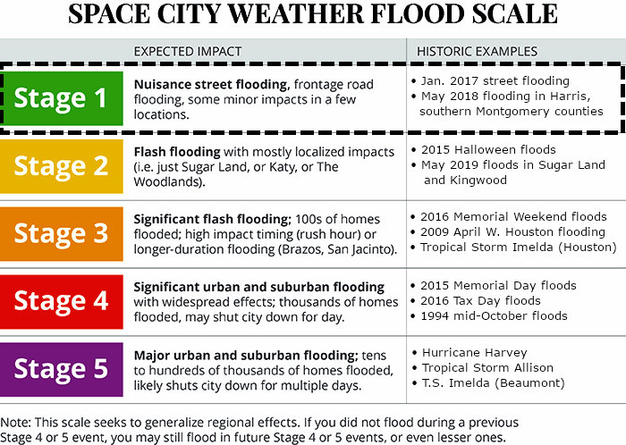
To that end we’re lowering the entire metro area to a Stage 1 flood alert on our flood scale, bringing the coastal areas (previously Stage 2) into alignment with the rest of the area. Generally, we think most of the Houston area will see 1 to 4 inches of rainfall this weekend. The coast may see some blips above 5 inches, but over the course of a couple of days this should be manageable.
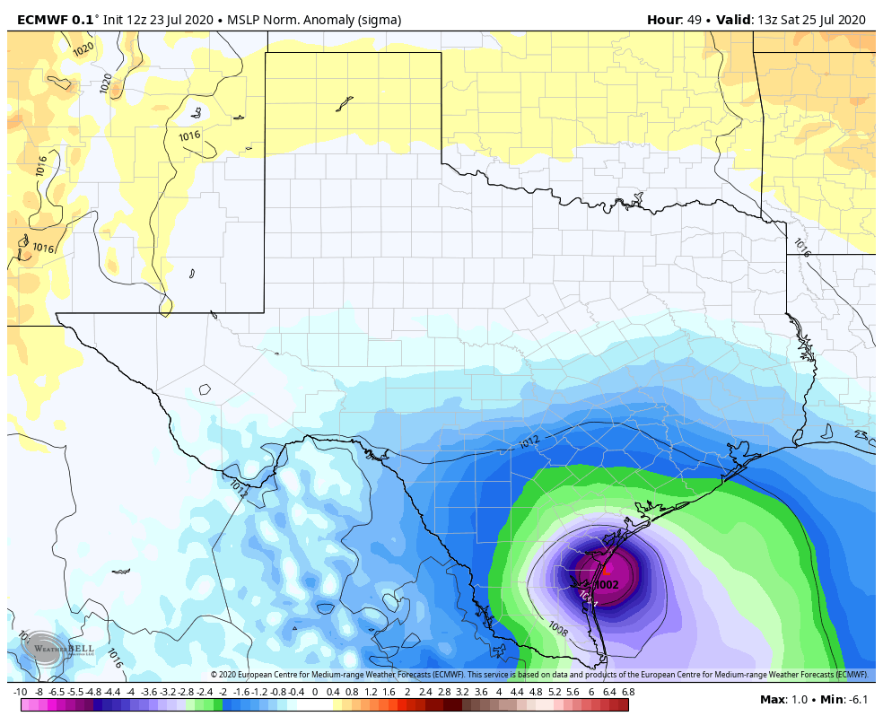
The biggest area of concern, in terms of rainfall, now appears to be an area from Matagorda Bay south to Corpus Christi, or Port Mansfield. We think there may be some bullseyes of 10+ inches in these areas. The depression, which may be on the verge of becoming Tropical Storm Hanna, is simply moving westward fast enough that it will hopefully limit long periods of heavy rainfall. We anticipate a landfall on Saturday morning, somewhere between Corpus Christi and Brownsville. Most of the strongest winds will be to the north of the landfalling location.
We will of course continue to track this depression, and if our forecast thinking changes we will update post haste. For now, however, you can expect a gray and wet weekend, but likely one without widespread street flooding, or worse.

How is Uvalde county (Concan) looking? We’re here for the weekend.
Thanks for keeping us posted Eric!
Guys, thanks for the update. Do you have any information about storm surge in the Galveston Bay area?
Sigh, it seems we live in a world of diminished expectations….
Thanks! Y’all are the best!
There’s a reason so many folks swear by Space City Weather. You tell us in plain English what to expect, and you revise your forecasts as warranted.
Let’s hope this is a “boring” year for the greater Houston area and that Katy doesn’t need to evacuate!
Thanks for keeping us informed with “just the facts.” (and telling us if there’s a lot of uncertainty) No forecast can ever be perfect.
Yet why do I have strong suspicion that this sentiment will NOT be expressed as 5:00 news leads!! Batten down the hatches!!
Thank you for keeping us informed! I work at grocery store and it’s always really nice to know I may not have to drive through terrible flooding in the middle of a pandemic to get to work. 😉 But seriously, appreciate you guys.
…that should be work at A grocery store. Sheesh.
Wasn’t NOAA claiming 10% on at? 80% now? So why do they bother? It gives us a false sense of security.
We are going to be on the wet side of this storm so
It may not be wise to lower your threat level just yet
You must be new here…
As many have said: Eric and Matt do a great job of reporting forecasts without hype or hysteria. Glad to see that the updated forecast is to downgrade.
As Eric said, we still have two more months of prime hurricane-spawning season left so we may as well simmer down and save the hysterics for a “real” storm should it come. Knock on wood that we don’t.