On the local front: All remains calm and quiet. We continue to see optimal weather to help us dry out and continue picking up the pieces after Harvey. This weather will last well into next week. Either later this weekend or on Monday, we’ll probably have to talk a bit about some potentially hotter temperatures by mid to late next week. In the meantime, the weather looks delightful for September in Texas through the weekend. Otherwise, the eyes of the weather world are focused on Irma (and also Jose, which is taking an unfortunate track near the Caribbean). Let’s start with the latest on Irma.
Irma Now
In the last 18 hours or so, Irma has been undergoing some internal reshuffling (in meteorology speak, an eyewall replacement cycle and probably some land interactions) that has caused its maximum wind speeds to drop a bit. It’s now a category four storm with maximum sustained winds of 155 mph. This is actually quite common for storms of Irma’s character. What’s been so uncommon about Irma has been its reluctance to see any fluctuations in intensity until just recently. So for all intents and purposes, Irma is now behaving like a typical high-end, major hurricane.
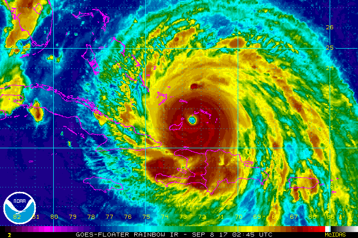
Irma is currently west of the Turks and Caicos Islands and just north of Baracoa and Guantanamo, Cuba. It continues to move north of due west and should just graze the coast of Cuba today.
Hurricane and storm surge watches and warnings have been posted for most of South Florida.

Irma Future
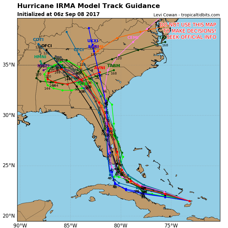
So what will Irma do from here? Eric hashed out a few possible track scenarios through this week. As of now, the odds of a Cuba brush to weaken it or a miss to the right of Florida are looking unfortunately unlikely. Most model data and an analysis of the steering currents show fairly high confidence right now in Irma turning and either hitting Miami directly or coming in just west of there. Neither of those scenarios would be good for Florida. A track just inland might weaken it faster, but it would likely cause more significant wind and surge damage in the Miami area. A track right along the east coast and up A1A would likely lead to slower weakening and more wind and surge further north up the coast.
Either way, we’re likely looking at a severe and damaging hurricane in much of the Florida Peninsula.
In terms of intensity, we will likely see Irma have some continued fluctuations, both up and down up through landfall. This means Irma will probably come ashore as a category four or five storm. Irma will be hitting extremely warm ocean water, some of the warmest it has encountered, as it turns northward toward Florida. It will also begin to experience a little more wind shear to hopefully help offset that a little as it approaches the coast. With some good fortune, and maybe a closer brush with Cuba today, Irma could come ashore as “only” a category three storm. The unfortunate reality is that there really are no “good” outcomes here, and Floridians should be ready for a very large and dangerous hurricane this weekend. Tropical storm and hurricane force winds will be likely up much of the Peninsula, along with significant coastal storm surge, particularly on the east coast of Florida.
Further up the coast, there is increased uncertainty, with Irma perhaps briefly coming back offshore before a second landfall in Georgia. That risk seems to be subsiding, but there is some uncertainty beyond day four of the forecast of exactly how Irma will track once in the Southeast.
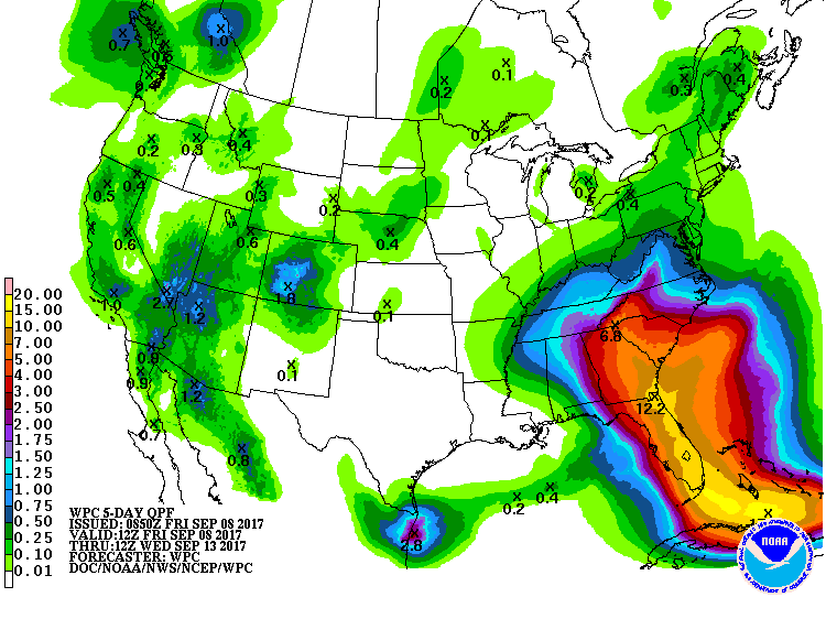
Inland rainfall, though well short of anything we experienced here in Texas during Harvey, will be substantial. Florida, Georgia, and South Carolina should expect a widespread 5-10 inches of rainfall, and pockets of 10-15″ possible in Florida.
Jose
A quick note on a cruel storm. Hurricane Jose now has 125 mph maximum sustained winds, and it is expected to maintain that intensity over the next couple days.
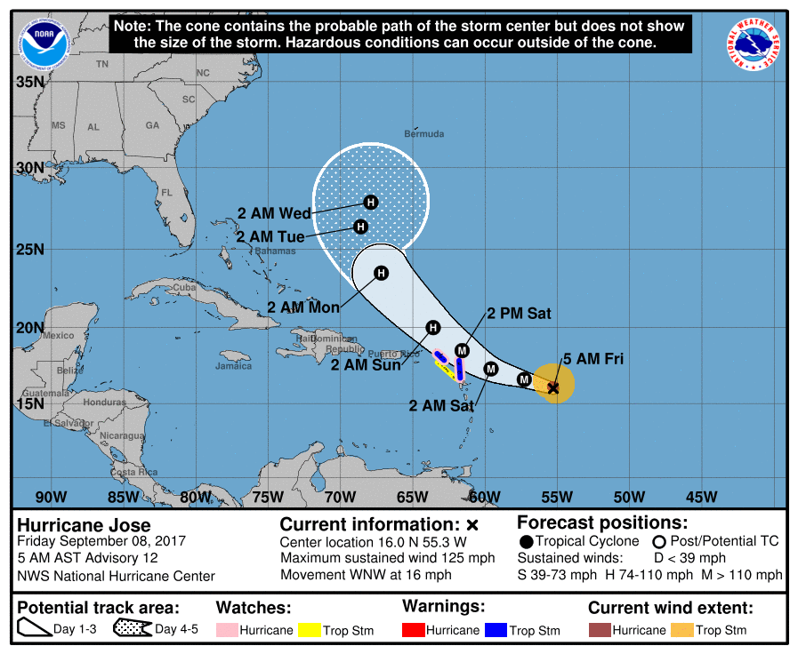
Why is Jose so cruel? Its path will take it very close to a couple of the same islands that have been devastated in the wake of Hurricane Irma. Though the current forecast will keep the strongest winds in the core of the storm north of those islands, even tropical storm impacts there will add a layer of misery to clean up and relief efforts. Fortunately, Jose looks to turn north, and it should either fall apart over the open ocean or eventually slide out to sea. Still, a cruel aspect of what is turning into an unfortunately memorable hurricane season.
You guys are amazing. I was in Houston throughout Harvey and my daughter drove from Boca Raton to Orlando on Wednesday. Hoping for the best with Irma but I only read your posts for my no frills, no hype factual data. I have completely stopped watching CNN and The Weather Channel, they are fear mongers.
Amen to not watching CNN and Weather Channel!
It was fun watching the weather standing in a hole on the strand after Harvery left Houston talking about how these businesses would be weaks, months, years, before they recovered. The some what flooded restaurant they were in front of was open the very next day.
I also watched one of the guys acting like he was struggling to stand against the wind in Harvey, while there were people walking down the side walk like it was nothing right behind him. Those guys are the worst.
How bad do you think storm surge will be in Naples?
http://www.nhc.noaa.gov/refresh/graphics_at1+shtml/093751.shtml?wsurge#contents
http://www.nhc.noaa.gov/refresh/graphics_at1+shtml/093751.shtml?inundation#contents
Up to 6 feet depending on your location.
Thanks to all.
Reading your posts very attentively here in Charlotte, NC. Thank you for your long hours in keeping us informed. Blessings on you all!
Grateful for all updates. It is true that I wait for the updates in your website and do not watch other websites etc. I am based in Kolkata ( Calcutta, India) and was a worried father as daughter and son in law are in Houston. My friend’s daughter is studying in Florida, ( northern side)…so eagerly wait for updates of Irma now.
keep up the good work…heartiest best wishes and love for all of you.
Should orlandoans head north??
Mind the local OEM.
http://www.floridadisaster.org/index.asp
http://www.cityoforlando.net/emergency/
https://twitter.com/citybeautiful
Know your area’s flood zones. Although Orlando is higher (112 ft) than Houston (43 ft), the topography is not flat but bowl shaped. With enough rain it will flood. For more specifics…
Local print media today: http://www.orlandosentinel.com/weather/hurricane/os-orlando-flood-worst-scenario-20170831-story.html
Attached maps (having difficulty in pulling this up at the time I’m replying): http://content.orlandosentinel.com/maps/flood-1-percent-annual/
I appreciate what you all do. You all were a life saver for me during Harvey, and I’m happy to see that you extend your brand of coverage beyond just the storms that affect the Houston area.
Most of my family and friends are in Florida and I just shared your website with all of them.
Keep up the good work. I think you all are on the cusp of something big.
Thank you for all the current information. I just went through Harvey in Houston and now my sister and niece face Irma. This is my trustworthy weather site. Appreciate the updates
Continued great job on “no hype, just the facts,” and when prudent, probabilities when the “facts” just aren’t there. Fear a bad scene for Florida, but still hoping and praying for less destruction and misery. At least the great majority of people have heeded the warnings and gotten out of town ahead of this beast.
You guys are great! My Houston-area son is sharing your Irma & Jose posts with me here in South Carolina. I appreciate your updates immensely – Thank you!
In the panhandle of Florida! I have been recommending you to all my friends after your incredibly competent coverage of Harvey.
This link shows an interesting and terrifying comparison of Irma and Andrew:
http://theweek.com/speedreads/723431/hurricane-irma-now-category-4-storm-but-florida-expects-worse-than-1992s-andrew
Look at the sheer size of Irma! If that goes up the center of FL I doubt there would be any place that’s safe. Best wishes to the people who must ride that out because that’s their job. I’ll also wish the people who choose to stay good luck, but I think they are being foolish.
The loop around northern Alabama is concerning- – – another STALL?
(Think I mistakenly deleted my comments) I live 40 minutes outside of NYC, discovered your site during Hurricane Harvey and have been transfixed every since by the “calmness” of your forecasts (Remember I’m from NY and am used to more frantic tones.) Your explanations of what is really going on are so concise as are your descriptions of how various hurricanes act.
I plan to continue to read your website for a long time and thanks for using the word “truthfully” so much.
Will the overall size and low pressure of Irma affect the path of Jose? NHC has been calling for Jose to be a fish storm since it formed, but the wind history chart is stick-straight and seems to be chasing Irma. Will the first storm counteract or enhance the mid-Atlantic pull towards the north?
http://www.nhc.noaa.gov/refresh/graphics_at2+shtml/174742.shtml?swath#contents
Just want to weigh in with everyone else thanking you guys for your continued work. I live in Houston and my sister lives in Melbourne, Florida, so Space City Weather has been my family’s saving grace the past couple of weeks.
I echo all the comments above, and want to express my appreciation for your coverage of Hurricane Harvey as well. I live in Houston, and was out of the country on an extended business trip when Harvey hit. I was frantic with worry about my kids and aging parents. Your website provided so much useful information that was based on the facts and not media hysteria whose sole purpose is to generate more attention to themselves. I plan to read your blog for many years to come, and am glad to see that you are providing the same excellent coverage on Hurricane Irma.