There’s not a whole lot to say new about Hurricane Irma this evening. So far, the storm is threading the needle through the area between Cuba and the Bahamas, and heading toward the Florida Keys. The Keys face widespread damage and this near hysterical tweet from the National Weather Service is entirely appropriate.
***THIS IS AS REAL AS IT GETS***
***NOWHERE IN THE FLORIDA KEYS WILL BE SAFE***
***YOU STILL HAVE TIME TO EVACUATE***
Please RT. #Irma pic.twitter.com/VWLMEDWoUs
— NWS Key West (@NWSKeyWest) September 8, 2017
Now that we’re about 48 hours from a final landfall somewhere in Florida we can have a fair amount of confidence in the track forecast for Irma, but there are still some important questions that ultimately will determine which parts of Florida see really bad conditions, and which see catastrophic conditions.
Cuba?
As of 4pm CT, here is the official track for Irma:
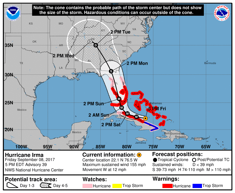
If you look closely at the hurricane center’s forecast track between now and Saturday evening, it brings the eye of Irma very close to Cuba. Recent satellite images from Friday evening show a westward movement that may, in fact, bring the center of the storm over the island for a time. If this happens, we may well see some weakening from the storm’s present 155-mph winds.
On Thursday evening, I posted about a couple of scenarios that could spare the greater Miami region from the worst damage from Irma, including “The Cuban,” which brought the storm over Cuba and then along a more westerly track, making a landfall somewhere near or south of Fort Myers on the southwestern coast of Florida. As of this evening, this scenario now seems a little more likely.
Regardless of whether Irma spends some time over Cuba, the storm’s track does seem to be moving west of Miami, and when it comes to top-level winds from a hurricane, miles matter. (For example, the difference between 90-mph sustained winds and 120-mph sustained winds is really significant). To that end, here are the Euro ensemble forecasts (released at 2:30pm CT Friday) for Irma’s position on Sunday, shortly after noon.
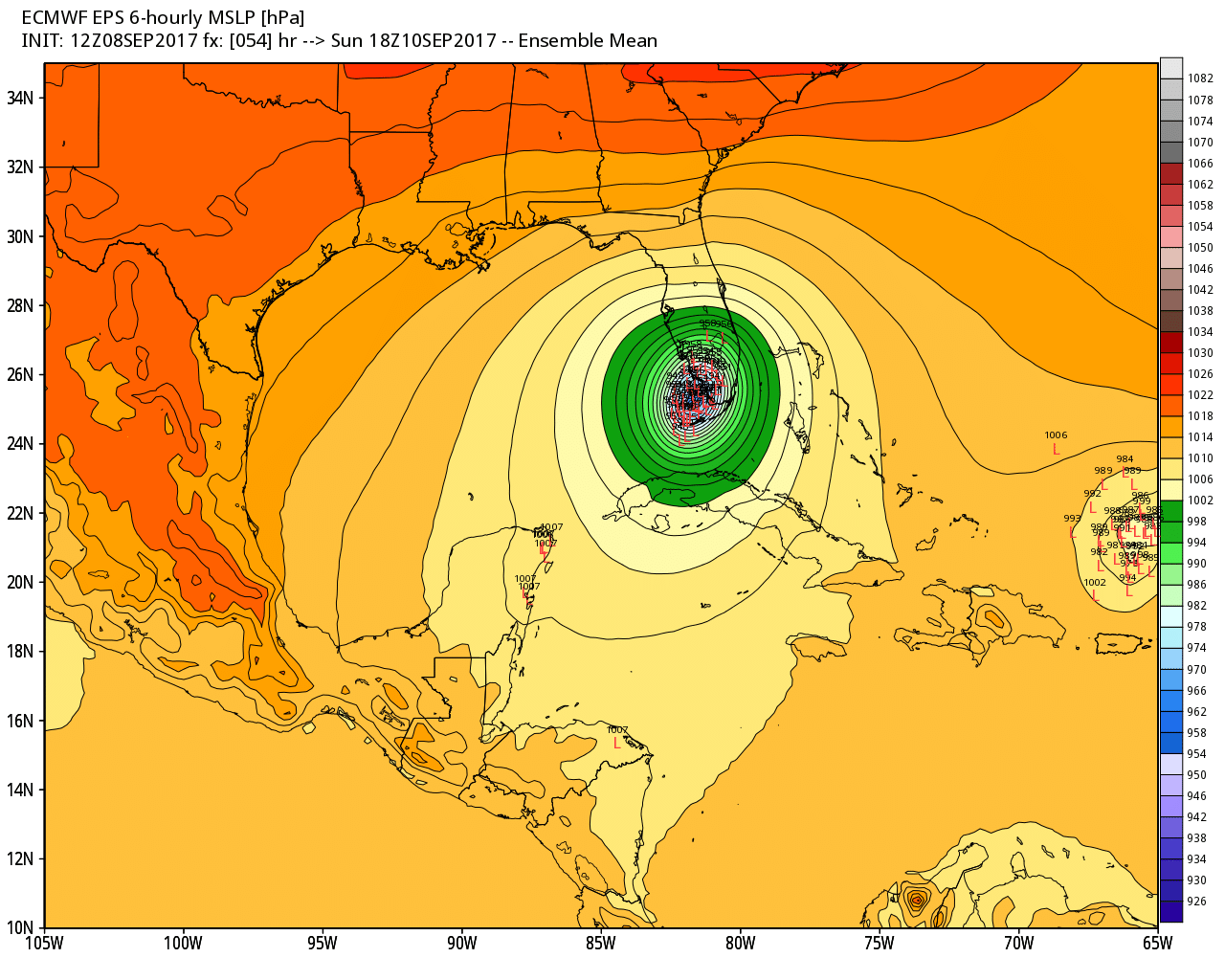
What is important to see here is that quite a few of the ensemble members are pretty far west of Miami, sparing the city from a catastrophic storm surge, and some of the heaviest winds. (Of course those effects would be transferred to the southwestern coast of Florida, including the Fort Meyers, Cape Coral, and Naples area).
What we know
- There is now a good probability that Irma spends some time over Cuba, which may lead to at least a little weakening.
- The Florida Keys are going to get absolutely smacked. Heed evacuation orders and get out.
- It’s not yet clear which part Southern Florida will be hit the hardest. The Miami area has a chance to escape the worst.
- The entire state of Florida is at high risk of damaging winds, very heavy inland rainfall, and other hurricane hazards beginning this weekend. They will need our help when this is over.
Thanks for your candor, hard work, and continued coverage. Our eyes are open here in Texas and we are keeping those in the path of the storm in our thoughts.
Thanks for giving us the no-hype facts. I think after this season is over we’re going to start a fundraiser to send you and Matt on a vacation.
I am looking forward to a vacation!
I’m seriously going to give you one. You have my email address so once things calm down please contact me and I’ll send you on a trip with your family.
Only if you take your “family” aka in laws with you!
I would contribute for Eric and Matt to go on vacation for sure.
A well deserved vacation. You guided us through Harvey, your no bs is a plus for a negative situation.
Hurricane season ends November 30! Can you wait?
Great idea, James!
I would absolutely contribute to that
Thanks Eric,
As I Said Yesterday, I Think IRMA&
JOSE Have Been Interacting In
A Little Fujiwara Dance…& Between
That& The Strong Subtropical
High Pressure Ridge Have Kept
IRMA From Turning Northwest So
Far..,But IRMA Is Now Beginning
To Slow, Which May Mean It Will
Begin To Turn…Cuba May Have Also
Slowed It.
All Irma hysteria is justified. Like that warning about Ike said, if you stay, the odds are that you die.
Please leave.
Any concern that since the storm is now potentially going to be over the Everglades (and potentially Lake Okeechobee) will that actually make it take longer to dissipate?
Not really. It’s going to be running into land and higher wind shear. I am pretty concerned about salt water intrusion into the Everglades, however.
Natural occurrence, happened before, will happen again, and life finds a way, sayeth Darwin and Teilhard de Chardin. Do not fret. It will sort itself out…
Please keep updates coming about Naples specifically – very interested in this area.
We’ll have an update in the morning.
Can you also throw in your thoughts about Tampa? I live there and am hunkering down in a concrete block house built to withstand this kind of stuff. That said, I am concerned about collateral damage/etc, and just wondering what to expect…
BTW, a colleague who lives in Houston referred me to your site, and I love the in-depth analysis! I’m a weather junkie at heart, and love reading about this stuff. Keep it up!
It’s looking like Irma may take a similar path that Hurricane Charley took in 2004.
For days, we heard that Irma should turn north and then northeast. Is it possible that Jose impacts Irma’s track in any way? Do the mathematical models consider two hurricanes?
“Do the mathematical models consider two hurricanes?”
Of course they do!
Hi, Eric! We live in the far west of the Panhandle. What the odds of Irma affecting us?
What are the chances it pops out on the gulf side of Cuba and hits Texas or Louisiana? We don’t want to have to evacuate at the 11th hour since they keep focusing on a Florida landfall
I’ve been wondering about this too
Thanks so much. Shutters up, supplies in check, braced for reality. From Coral Springs, FL.
Thanks from Ft. Lauderdale– Excellent coverage!
My dad is in Tampa and won’t leave. I’m getting more worried about him by the minute.
My mom already flew in to stay with me. I’m in Houston (but dry).
Once it hits Florida, what’s the track after? What other states are in her path? Specifically the Carolinas and Virginia.
How does the size of Irma compare to the size of Ike? I saw a graphic of Andrew and Irma and the size difference was considerable.
I have a brother in Dunnellon, FLA and hve been forwarding your posts to him. He is boarded up, battened downed, and supplied. He is not coastal, but Irma is scary. Also – staying out of the way of those evacing south Florida.
Any truth to the rumors a landfall in the Everglades will lead to the threat of flying alligators all throughout Florida because of the unprecedented wind speeds? The thought totally frightens me.
It can happen. They made a pretty realistic movie about this, just look up Sharknado.
That’s exactly what I was thinking. #gatornado
Again, and again, you deliver straightforward news on these storms. Thank you for your tireless dedication to keeping us all informed!
I’m very curious where we all can find the data on NHC predicted path vs actual path the storms took. Were they historically accurate in predicting? Close? Not close? Where might one find that type of data?
Thank you again, Eric!
Thank you again, Matt!
My mom is in Ft Meyers. If YOUR mom was in Ft Meyers what would you tell her to do?Mine seems to think this is cute and shes safe. She wont listen to me. Maybe if she listens to you……….
In addition to S-Simpson scale, wasn’t another criterion supposed to be added to describe hurricane strength this year?
Would you mind taking a look at Jose – European model has it hitting the west coast of Florida later this week and not in a nice way.
The vast majority of ensemble members of the European model keep Jose offshore, and as of now I’m inclined to believe that happens.