Good morning. In today’s post we’ll talk about the weather for the week of Thanksgiving—which should be fairly pleasant for the holiday itself, if warmer than normal—the likelihood of a stronger cold front during the coming weekend, and discuss what our warmish fall may mean for our upcoming winter. Also, I’d like to remind you that we are entering the final week of our annual fundraiser, during which you can support the site through buying merchandise or simply donating. We appreciate the tremendous response so far this year.
Winter is (not) coming?
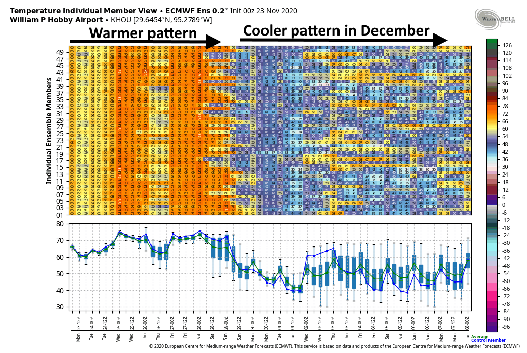
The Houston region has twice gotten as cold as 42 degrees this fall at Bush Intercontinental Airport, but we have yet to dip into the 30s in the metro area—what I would generally define as “cold” or “winter-like” weather. On the flip side, a lot of nights this month have been quite warm for November, with more than one-third of lows not reaching 60 degrees or below. This rather warm end of fall may make you wonder whether we’re going to see sustained, winter-like weather this season.
I think the answer is yes. This week is, indeed, going to be fairly warm, with highs in the 70s (and possibly 80 for a few locations), and nights will not be cold. But the extended models suggest we’ll enter a much colder pattern by Sunday, and that it’s going to stick around for awhile in December. It is true that we are in a La Niña, a fairly strong one, and this typically means we see somewhat warmer than normal conditions during December, January, and February. However, that does not mean the region will not see nights in the 30s and at least a handful of freezes. So hang on—Houston should start to experience more winter-like weather soon. For some winter energy saving tips please check the message from Reliant at the end of this post.
Monday
A weak front has moved into the Houston region during the overnight hours, and it will lead to a pleasant, fall-like day for the region. As drier air filters into the area, we should see partly to mostly sunny skies by this afternoon, and high temperatures will climb into the low 70s for most areas. Winds will be light out of the north, shifting to the east. Lows tonight should drop to around 60 degrees in Houston, with warmer conditions along the coast, and 50s further inland.
Tuesday
Winds will shift to come from onshore by Monday night, and this will set up a warmer, more humid day on Tuesday, with highs of around 80 degrees and partly to mostly cloudy skies. Low temperatures on Tuesday night will be 5 to 10 degrees warmer.
Wednesday
The second front of the week should push into Houston on Wednesday, perhaps reaching western parts of the region during the morning hours, and moving to the coast by noon, or during the afternoon hours. There will be perhaps a 30 percent chance of rain with the front—showers would be brief, and not particularly heavy—before skies clear out in the wake of the front. Highs will likely be in the 70s before overnight temperatures drop into the 50s for everyone in the region except for the immediate coast.
Thanksgiving
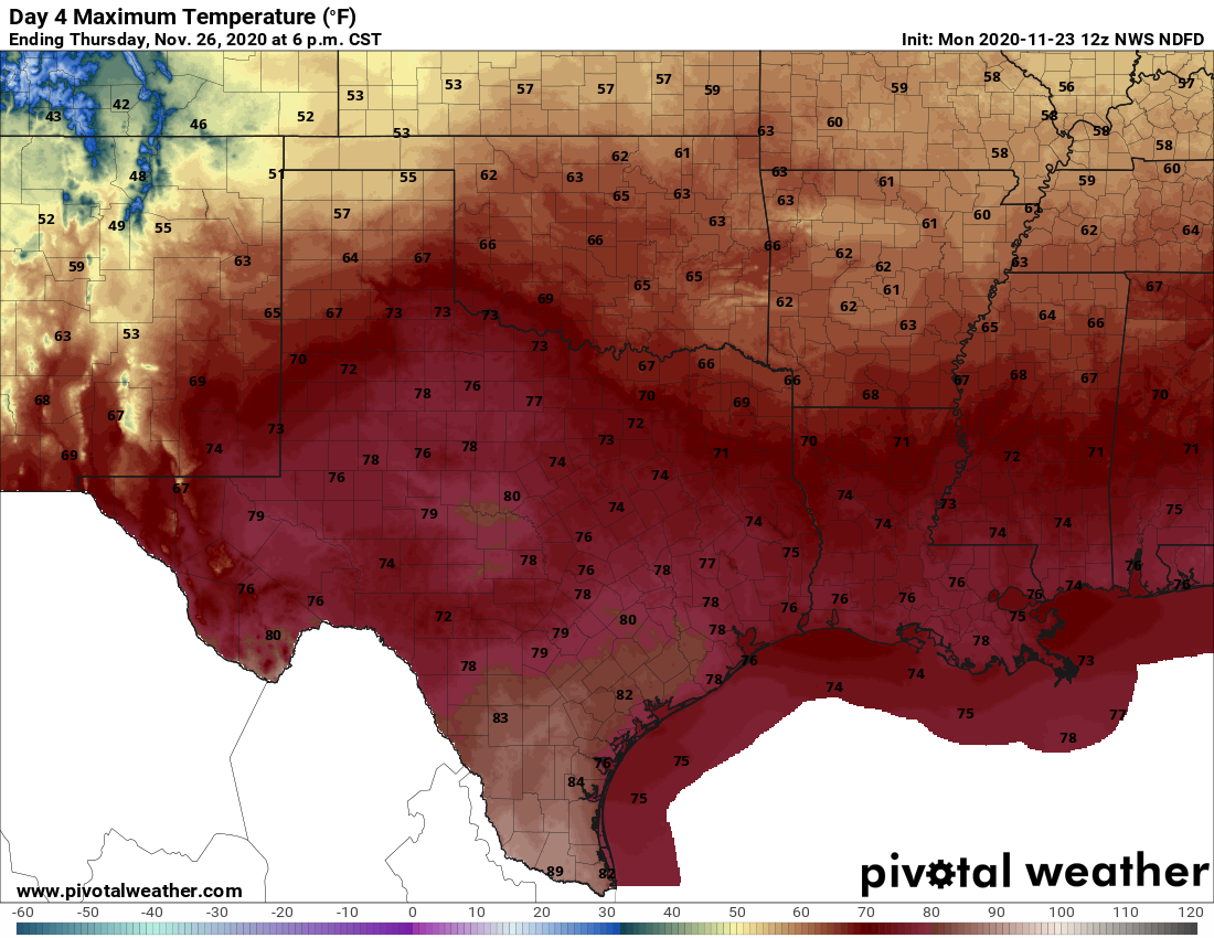
Most of the holiday should see fair weather in the wake of the front, with highs in the upper 70s and partly sunny skies. However, this front will be another short-lived affair, so the onshore flow should resume later on Thanksgiving and lead to a fairly warm and muggy night with lows struggling to fall below 70 degrees for many locations in the metro area.
Friday, Saturday, and Sunday
At this point the big picture for this weekend seems pretty clear: We’ll see clouds and pretty healthy rain chances on Friday and Saturday before a fairly strong cold front moves into the region. But will the front arrive on Saturday afternoon? Or Sunday morning? Right now I don’t know, and that’s going to have a big impact on daily weather conditions. The bottom line is that most of the area should see some much needed rain toward the end of this week—perhaps 1 to 3 inches—before a more winter-like front moves through. We may even finally see some lows in the 30s by the time early December rolls around.
Message from Reliant
A few conscious energy choices can make a big difference in your winter electricity bill. Considering heating and cooling costs account for nearly 50 percent of your electricity bill, increased heater usage can lead to higher-than-normal winter bills — if energy efficiency measures aren’t taken. An annual heater tune-up is recommended to make sure your furnace or heat pump is clean and in good working order, so that it can run as efficiently as it should.
Reliant has a few tips you can do immediately to reduce energy consumption and still stay comfortable. Best of all, they’re simple and free.
- Let the sun in. Open blinds and shades during the day and remove any solar screens so the sun can warm your home.
- On vs. auto. Ensure the fan on your thermostat is set to “auto” not “on” to prevent it from running 24/7.
- Check your thermostat settings. For every degree above 70°, you can expect a 3-5 percent increase in your heating costs.
- Turn your ceiling fan to clockwise position. By turning your ceiling fan to the clockwise position, you can help force warm air down to create a more comfortable environment in colder seasons.
- Put your thermostat on vacation mode. Drop your thermostat to 50° if you’ll be gone for a few days or more. This is warm enough to prevent your pipes from freezing and won’t waste energy warming an empty home.
- Set your water heater to 120°. This is hot enough to be sanitary while saving you up to $60 a year on your heating bill.
- Use exhaust fans in moderation. Be mindful of how often you’re using bathroom or utility room vents as they can remove heat from your home.
- Close damper on fireplace. When not in use, ensure the damper on your fireplace is closed so heat does not escape up the chimney.

While I always root for cool weather, the current pattern isn’t the worst possible outcome. With 2020 being so freaky, I’m definitely more tolerant of slightly warmer but drier fall weather.
My AC bill is thankful for the decreased use.
We want snow, we want snow, we want snow…..
With three months yet of possible cold weather I’m not optimistic we’ll miss winter this year. As I recall it got colder sooner than usual and since it’s been warm. But that can, (and likely will), change. Not putting away the winter coat yet.
Since we’re not leaving the house right now anyway, a mild winter would be OK, a cooler winter even better, but I could pass on the “few freezes,” especially the fronts that blow in with a bucket of bone-rattling wind and rain. Those mean hauling all the plants inside and outside each time, and the significant weather flip-flops are hard on the outdoor foliage and wildlife. The near-drought/drought and sudden, sustained temperature drops are also really bad for the trees. We’ll roll with whatever comes, of course, but that would be my preference if we’re taking orders. 😉
Happy Thanksgiving, all! Be safe out there.
Most every forecast I’ve seen for the US is that the majority of the country will have a fall and winter season that is somewhat warmer than average with below average precipitation. That would be a good thing since everything needs to be outdoors this year and you have to bring your own turkey.
Why does the air smell like shoe polish this morning?
La Nina is more favorable to Atlantic hurricane formation, right? How much longer is it expected to last?
Ordered a SCW umbrella, looking forward to using it!