Here’s the short answer up front: Probably. Barring some kind of an unexpected, freakishly cold front coming through in the next few weeks, we’re done.
Now, for a longer answer. Crazier things have happened. Houston’s latest ever recorded freeze came on April 10, 1973. However, the odds are against this. For areas south of Interstate 10, we are already past the “average” date of the region’s last freeze, and we’re fast approaching that date for areas along and north of Interstate 10. For areas further inland, such as Conroe, the typical date of the last freeze comes in late February.
After a front moves through early tomorrow, we are going to see a couple of days of colder weather. Some far inland areas, including Conroe, have a chance of seeing a light freeze on Friday and Saturday mornings. But after that? We look to be near or above normal, in terms of temperatures, for the rest of February. So I would be surprised if it froze again. For areas along and south of Interstate 10, I’d put the chance of another freeze this season at 10 percent or less. For the northern half of the metro area, it is probably about 25 percent, or less.
Wednesday
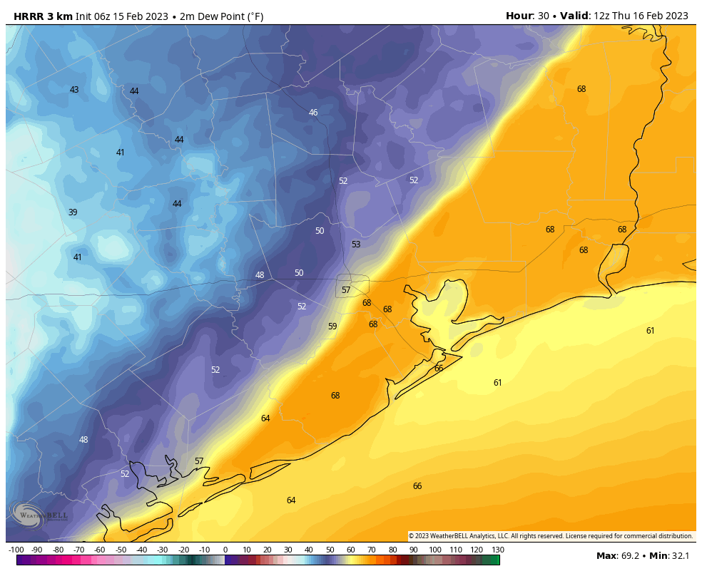
Patchy to dense fog is present this morning as winds are light, and dewpoints and temperatures nearly match in the upper 60s. As temperatures warm this morning, the fog will dissipate, and leave us with cloudy skies. A very few, scattered showers will be possible later this morning and during the afternoon hours, with highs reaching about 80 degrees. Tonight will be sticky warm until the front comes through.
Thursday
Speaking of said front, a broken line of showers and perhaps a few thunderstorms will herald its arrival. They’ll pass quickly. Generally, we can expect the front to reach western portions of the region, such as Katy, around 3 to 5 am on Thursday, downtown from 5 to 7 am, and the coast from 7 to 9 am. Showers will end quickly with the front’s passage, but clouds will remain. Temperatures will drop into the lower 60s in the morning, and perhaps the 50s during the afternoon, as brisk northerly winds gust to 30 mph or so and bring in colder, drier air. Lows on Thursday night will drop into the upper 30s for much of Houston.
Friday
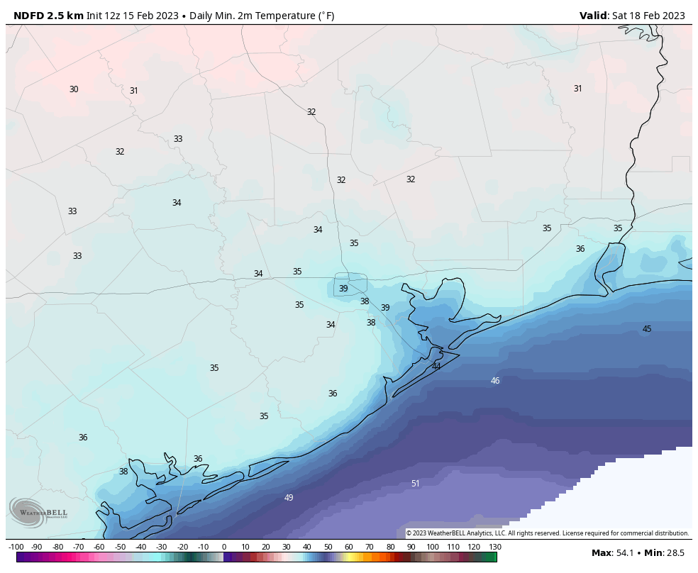
A sunny, and chilly day, with highs in the mid-50s. Winds will still be around, but backing off into the 10 to 15 mph range, with higher gusts. Lows Friday night will again drop into the upper 30s, with a light freeze possible for far inland areas.
Saturday
One more cool day, with partly sunny skies and highs in the upper 50s. As winds start to turn more southerly, temperatures will be warmer, in the 40s, overnight.
Sunday
Expect mostly sunny, and fine weather with highs around 70 degrees or a tick above.
Next week
Washington’s Birthday should see warmer conditions, with partly sunny skies and highs near 80 degrees. Some sort of front is going to try and make it through by mid-week, but I’m not 100 percent confident that will happen. A smattering of rain chances pop up around the same time, but they’re not particularly impressive looking.


FYI… I saw that your SCW article was cross posted to Spoutible yesterday.
Thank you so much -I look forward to reading the forecast as yours is the only one I go bye-thank you again
What do you think the chances are of a frost after this weekend? (Specifically, The Woodlands/Spring area) Debating on when we can bring out my wife’s succulents to the patio.
According to the Space City Weather post above, after this weekend, there is about a probable 25% chance or less (< 25%) of it freezing in the northern Houston Metro area. The post infers areas north of Interstate 10. The Woodlands/ Spring area is north of Interstate 10. I hope this helps.
I was looking more for frost date. Succulents are more sensitive to frost than most, so generally won’t put them outside until we’re reasonably expected to stay above 37F or so.
Except for the one freeze the week before Christmas, I’ve had my succulents out all winter. I’m in the Atascocita area near Lk Houston.
I think the caption on your first HRRR map needs to be edited. Perhaps you meant Thursday? Appreciate you guys immensely.
This is GREAT news for us gardeners. Time to get planting!
I hope this frost moves on quickly. So tired of these cold fronts. They have damaged the city so bad. Ugly everywhere.
That’s not “damage”, that is “winter”. It will green up soon enough.
The past three years (while overall warmer than average) have had unusually cold spells. Tropical plants like my banana trees don’t green up that quickly after it gets into the teens, let alone produce fruit quickly.
Two years, I mean.
This is what happens when people plant non-native, non-ecoregion plants. While warm/humid a great portion of the year and tropical-like, it is not a tropical horticulture growth zone.