Good morning. The first of two cold fronts will arrive in Houston today. This first front will be short-lived, and provide only minimal cooling, before a quick warm-up. However, a second front on Wednesday night will drive temperatures back down to the 30s for a few days. The weekend looks pleasant, and suitable for outdoor activities.
Tuesday
There’s a fair amount going on with today’s weather. We have a few light rain showers developing this morning, as they feed upon a decently moist atmosphere. Winds are also rather blowy, out of the south at 15 mph and gusting to 30 mph or higher at times. A chance of showers, mostly light but perhaps with a few thunderstorms thrown in, will linger through much of the morning before the front moves into the area. Rather than providing a cool down, as skies clear with the frontal passage, highs will bump up to around 80 degrees. Depending on how far you live from the coast, lows tonight will either fall into the low 50s or upper 50s.
Wednesday
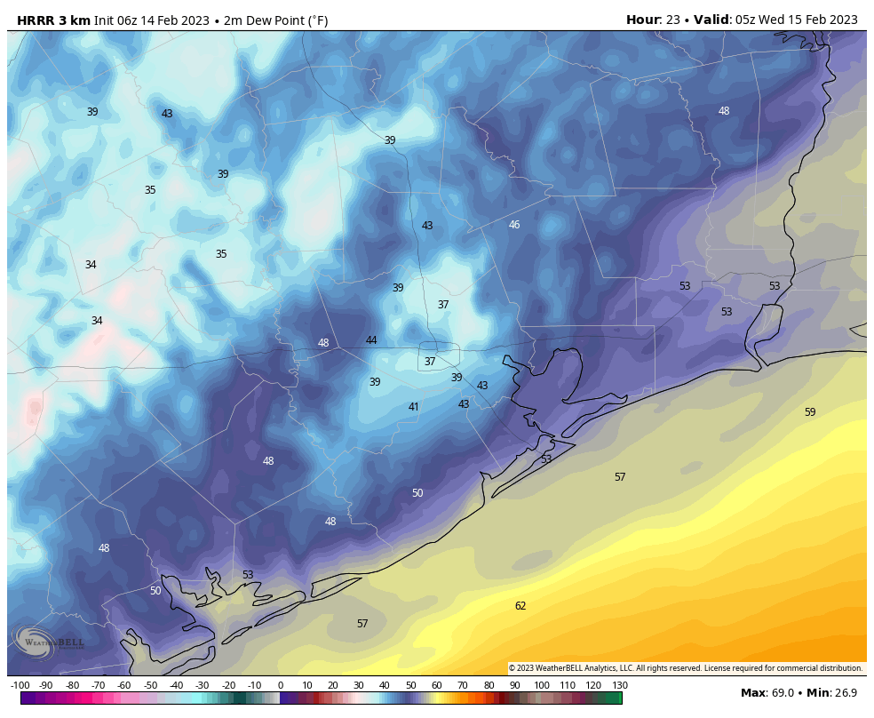
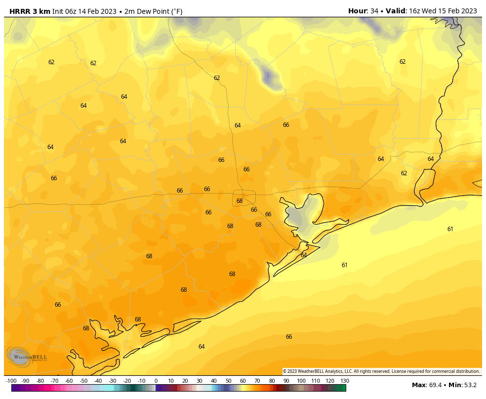
The aforementioned front is not going far. It should make it all the way to the Texas coast before stalling and pulling back north on Wednesday morning. This will be noticeable in dewpoints if you step outside. By around midnight on Tuesday, they’ll probably be in the 30s in the urban core of Houston, which is really pretty dry. Eight to 10 hours later, on Wednesday morning, they’ll probably have rebounded into the low 60s. By Wednesday afternoon they’ll be pushing 70 degrees which, along with an air temperature in the mid 70s, will feel pretty sticky. Beneath mostly cloudy skies a few scattered, light showers will be possible on Wednesday as the atmosphere moistens back up. Lows Wednesday night won’t drop much below the upper 60s in most of the region.
Thursday
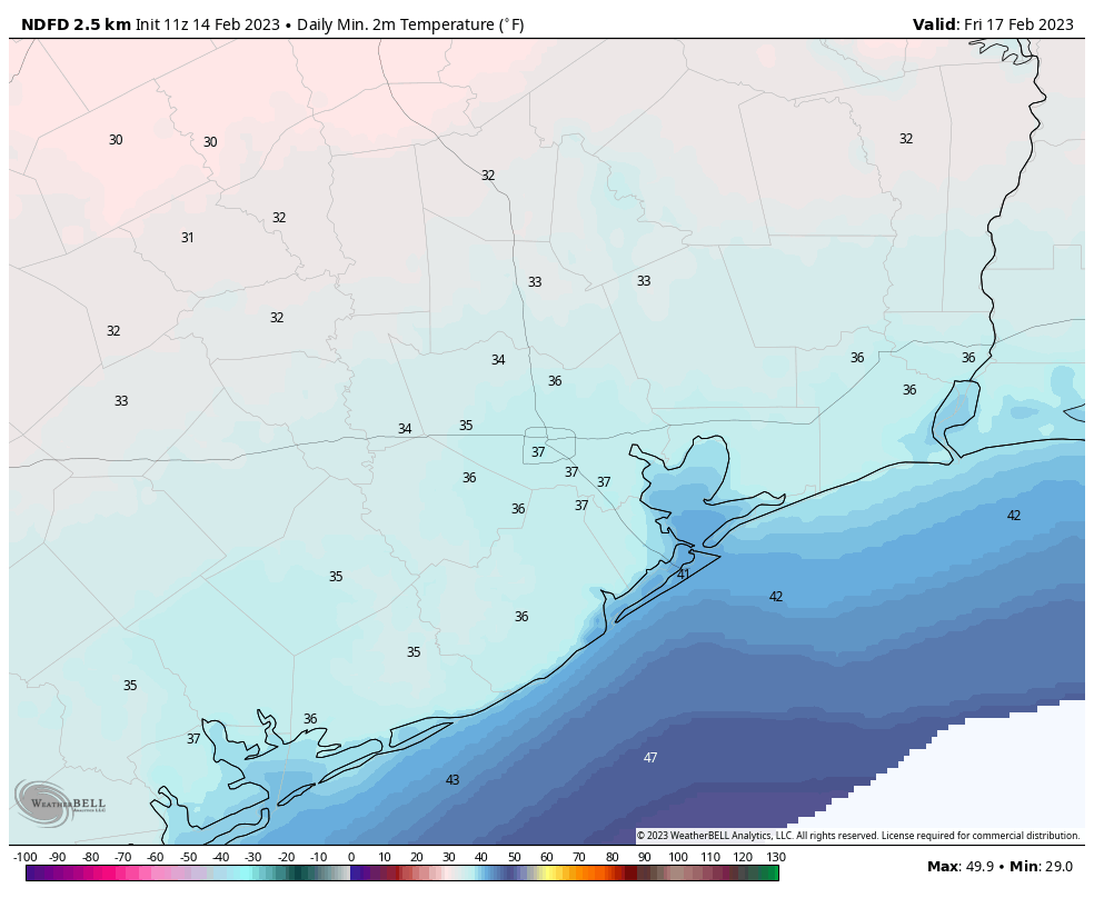
A second, and stronger front will move through the area early on Thursday, likely reaching downtown Houston before sunrise and pushing off the coast between 7 and 9 am CT. Some scattered showers will be possible between midnight and Thursday morning along with the front, but again these will be mostly light, and inconsequential. Winds will be gusty, out of the north, on Thursday, perhaps up to 30 mph. Daytime temperatures will be in the mid-50s, with mostly cloudy skies. Overnight lows will drop into the 30s except for the immediate coast. Most of Houston will remain above freezing, however.
Friday
Expect a sunny, chilly day with highs in the mid-50s. A few clouds return Friday night, when lows should be similar to Thursday night.
Saturday and Sunday
The first half of the weekend will be cooler, with highs of around 60 degrees and partly sunny skies. Temperatures will moderate some on Saturday night, only dropping into the mid-40s. This onshore flow will introduce some clouds on Sunday, but we should also see a bit of sunshine as highs reach about 70 degrees. Rain chances are near nil for the weekend, so plan your outdoor activities with confidence.
Next week
Most of next week looks warm, with partly to mostly cloudy skies, and highs in the vicinity of 80 degrees. I’m not seeing much of a signal for rain. Some kind of front may arrive by Thursday or Friday, but overall details are lacking at this point, as one might expect.


I’m just trying to start my spring garden, fam 😭
Good morning! Is there any long-range forecast (guessing?) for what we might be looking at weather-wise for the 26th? Tour de Houston is then, and I hope to know what we’re looking at. Thanks very much, as ever!
too far ahead in time for a reasonable guess in weather for Tour stranger.
Are we done with freezes in Houston?
Were you here in Houston exactly 2 years ago, Feb 14, 2021?
“Winds are also rather blowy” is my favorite description of wind
Any more clarity on the potential of a polar vortex event that folks were worried about last week?
Cold weather needs to hurry up. It feels disgusting outside today.