Good morning. I hope everyone is finding some peace on Labor Day morning. Our short-term forecast remains more or less locked in for the Houston area, with warm-ish days through Wednesday (highs in the low 90s) before a cold front moves through and brings absolutely splendid weather for the second half of this week. We may see some decent rain chances on Tuesday and Wednesday due to the approaching front, but even so most areas probably won’t see more than about a tenth of an inch of rain (if that).
With that said, we’ve had a lot of questions about the tropics—understandably people are still pretty skittish after our brush with Hurricane Harvey. We get that. So here’s a review of what’s out there. Also, I’d like to remind everyone that while the Atlantic hurricane season officially lasts until Nov. 30, for Texas is effectively ends in about three or four weeks. We are almost there, folks.
Hurricane Irma
All eyes are on Irma, a major hurricane with sustained winds of 120mph moving toward the Northwestern Caribbean Sea. It should reach the vicinity of Puerto Rico by Wednesday night, and poses a significant threat to the Caribbean Islands. Here’s the latest (10am CT) track forecast from the National Hurricane Center.
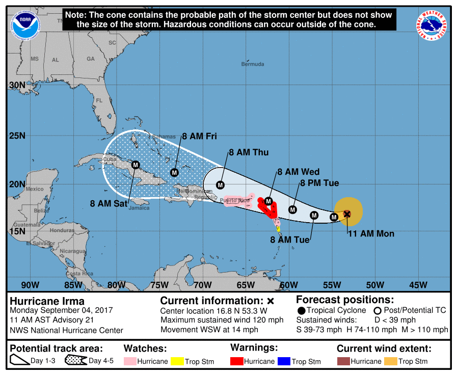
Understandably there is a lot of concern about where the system goes in five to seven days, when it begins to approach Florida and the continental United States. There has been a westward movement in the forecast models over the last day or two, leading to some local concerns that the track may continue to shift westward toward a Texas landfall. We continue to remain pretty confident that is not going to happen.
With that said, the storm’s movement after about Thursday is fairly uncertain. Generally, the ensemble members of both the European and GFS models show the storm moving west-northwest just north of Cuba, and making a turn north just before reaching Florida, over Florida, or just after Florida (into the eastern Gulf of Mexico). Irma is expected to make this northern turn after it finds the western edge of a large ridge of high pressure over the Atlantic region, but at nearly a week from now it’s impossible to determine where that will be.

Our advice remains the same: Irma is likely not a Texas threat—most probably it will be a concern for Florida and the southeastern United States. (I’ve told family members in Houston not to worry). But if you’re a Houstonian sweating Irma after Harvey, we get that. We’ll be here every step of the way to follow the storm’s evolution and potential effects on the United States. The track should become a little more clear as NOAA begins to take more frequent atmospheric soundings over land today (improving model ability to predict the position of the Atlantic high pressure system), and reconnaissance aircraft begin to fly into the system. This should hopefully improve model forecasts tonight, and give us a better idea about the storm’s future movement by early Tuesday morning.
Tropical Blob
A low pressure system in the southern Gulf of Mexico has popped up on the 5-day outlook from the National Hurricane Center, which says the system will drift to the west or northwest as it remains over the southwestern Gulf of Mexico during the next few days. Given the arrival of a mid-week cold front, we don’t have any great concerns about this for the Houston area.
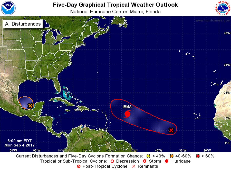
However, next week we may have to watch the southern Gulf of Mexico, because after the aforementioned front moves through Houston and deep into the Gulf, it may find a decent environment for development. Again, not anything we’re particularly concerned about, just something we’ll need to watch for rainfall potential in a week or 10 days.
Hurricane Harvey review
I had the good fortune to be featured in a lengthy Sunday story in the Houston Chronicle regarding Harvey. Videographer Mark Mulligan also produced this video, which I narrate. It’s quite powerful.
Hurricane Harvey from Houston Chronicle on Vimeo.
We’ll be back Tuesday morning with a regular update.
Posted on Monday, Sept. 4, 2017 at 9:40am CT
Thanks again for all you do! The Weather Underground has an article up today raising the possibility of a new storm “J” that might influence Irma to a more Southwest track. Hope you will address that in your next post… Thanks again.
There’s a lot of speculation about whats and ifs and such. For now, let’s see what the models do tonight with better data inputs from soundings and recon flights.
I agree with Gary, to see the storm now tracking WSW when I thought earlier the track was WNW makes my heart beat just a but faster. Given the gulf & what we just all went through, couldn’t the Gulf’s warm waters just grab it & pull it west? None of us want that but better for more readiness this time. The article & video was very moving.
Great video Eric. You make some good points while the video shows the impact if we just sit on our hands.
Thank you, Kris!
Thanks for your updates and for being straight with us. We here in Houston are concerned about Irma, but between your forecasts/information and the models we are tracking it looks like Texas might be spared. We’ll keep an eye out for your updates as always. Thanks for everything you guys do.
Yes, keep an eye on Irma, but don’t worry about it too much.
Uh, Eric—-assuming that blob in the Gulf does develop, where would it go?
Eric, you and Matt stayed in the fray to keep us informed after you sent your wife and daughter away…don’t really know what to say to you guys…God bless you all!
I talked to a friend yesterday and mentioned your site. Her comment was “Oh yeah – he was scaring people all over town”. I can’t say that. I know your comments scared some people. But you were only reporting what you saw could happen. And you were right. And we respect your information because we know you will call it as you see it. As it is; as it could be (so we can avoid it). I trust your stuff because I know you won’t call it bad unless it’s gonna be bad. And you did properly call this one. Other sources did as well….but they tend to hype things. Yours is truly a hype-free forecast and and therefore I put more stock in it.
I’m sure that every meteorologist in the region has PTSD right now. I know that dealing with all the people who depend on you (a role you probably never expected! Charles Barkley didn’t want to be a role model, either) has worn on your personally, as well as professionally. You have every right to be human. And nothing about this devastation is your fault. Nothing. Survivor guilt is real; thinking you could have done something is real…. and you did EVERYTHING you could. You prepared people.
Thank you.
I second Krystal. You guys were calling it as you saw it. You injected heart and humor into your posts, along with the non-hyped weather information. It was as if a friend was saying, “Brace yourself; it’s gonna be bad, but I’m in it with you all to the end.” We were watching the weather guys on TV, but you were on the couch with us, explaining, commiserating, and praying as if a part of the family.
Now, who do we bug to get you guys nominated for a Peabody (if there is one for weather blogs)?
Thanks for the info and the video. Your comment about the future of Houston is so true. I hope someone in power will heed your warning.
Really good video, well done. I hope your excellent forecasting and total dedication are rewarded with sponsors and financial security because you guys definitely have the praise and thanks of this city. ❤️
OK, Eric – – now you have me wondering about your “Glory” poster in the background…. Russian space program?
thank yall for being a calm voice right when i needed it. we can’t handle another big one again this year, we’re maxed out.
During Harvey – which model(s) were the most accurate in terms of landfall and rainfall?
European model first, and to a lesser extent the UK Met model.
Eric, I’ve followed your weather blog since you were the science guy at the Houston Chronicle. You’re absolutely super at reporting on tropical systems. Kudos on the outstanding job tracking Harvey, and condolences, too. I live in Florida and look forward to your detailed reporting on Hurricane Irma. Here’s hoping it affects no land areas on the Gulf Coast…or anywhere else.
Hoping the same, Brian. Thanks for the kind words.
Would Houston be likely to get any rain from Irma? I’m hopeful that we wouldn’t be on the “dirty” side of the storm.
At this time, the pro mets think it would be a threat for the E. Gulf. New Orleans, IMHO should be on guard for this one, sorry to say.
I was hunkered down in the Florida Panhandle (PCB area) where we have a little beach cottage, while Harvey flooded and destroyed our principal home in Houston. Is it possible that Irma will leave us entirely homeless? I’ll be watching your reporting closely, as I have since your days on the Chronicle, because you are the only one who ever seems to get it right. Bless your heart.
Hi Eric, my family survived Harvey from our home in Houston. We flew to Orlando this past Friday with our 5 year old for a prescheduled Disney vacation. We fly back to Houston on Sunday and have a rental car. If we can’t get a flight back because of the storm, we can drive out. Any idea how long we have to decide whether to leave Orlando by car? As you can imagine, we’re not looking forward to testing our luck with a second hurricane.
I love that you give solid and no-hype information not only for me and my kids, but also for my family in Wisconsin! They say that they feel much better about our safety after reading your site! THANK YOU!
I live in Houston and throughout Harvey I kept sending people your website to get updates from you and not me because you were straightforward and easy to understand with the different scenarios you laid out. I’m sure you got zero sleep, along with the rest of us, and have some sort of PTSD, along with the rest of us. I think you mentioned you sustained some damage? 🙏🏻
You are correct! Our city must have a thoughtful conversation about rain and the depth of the problem repeat flooding will have on Houston’s future. No one needs to argue noisily and fruitlessly about global warming, “environmental racism”, city zoning or lack of zoning — they have their place, but are diversions from survival. Harvey’s water soaked all of Houston to the core. And water will likely come again. Hearts, homes, lives, jobs are feeling the impact of the lows and the highs. Neighbor helping neighbor. Stranger helping stranger. Incredible response.
We MUST have engineers, businessfolk, the Mayor, locally voted officials, industry leaders, experts in various fields (like our most appreciated no-hype weatherman), our many Universities, architects, every day Houstonians who are active citizens – take part in conversations about the potential problems and solutions.
The levees, infrastructure, superfund sites, insurance programs, repeat flood areas should all be on the table.
Houston is strong, determined, diverse, creative, and BRILLIANT. We live, work, worship, and play here because it is a city that thrives. Let’s TALK, people!
Would be great to see forums held at schools, churches, synagogues, community centers, city hall, TSU, U of H, Rice, HISD, the Med Center, chemical plants, oil refineries, hotels, a summit at the George R. Brown, coffee shops and diners and every kitchen table… . The possibilities for engagement are endless.
Dear Eric and Matt,
Echoing the many thanks for your sterling efforts in keeping us informed on weather possibilities.
In conversations over the years with folks who have lived here much longer than I have (not quite 20 years for me), there is a strong impression that once the first significant cold front of the season makes it to the Gulf (as is forecast for sometime tomorrow), it is vanishingly rare for our part of the coast to see another tropical system. This is of course anecdotal, but ostensibly it would be because the fact a front could reach the Gulf is a harbinger of the cooling continent and other seasonal shifts.
Do you happen to know whether this is the case? I expect the only way to know would be to dig through the records and find the first arrival of north winds and dropping dew points each September-October, and compare to the list of storms that have reached our shores…