A cold front remains on track to reach Houston on Wednesday, arriving a couple of weeks early to the region, and bringing some genuinely fall-like weather to the upper Texas coast. I’ll also discuss Hurricane Irma, because the storm has reached Category 5 status and almost certainly will have some devastating effects in the United States. We remain pretty confident the storm won’t have major effects for Texas, however.
Tuesday
We’ll still be pretty warm today, with highs in the low 90s across Houston, but for early September this is still decent weather. Houston could see some scattered showers later this afternoon, but for the most part we should be rain-free.
Wednesday
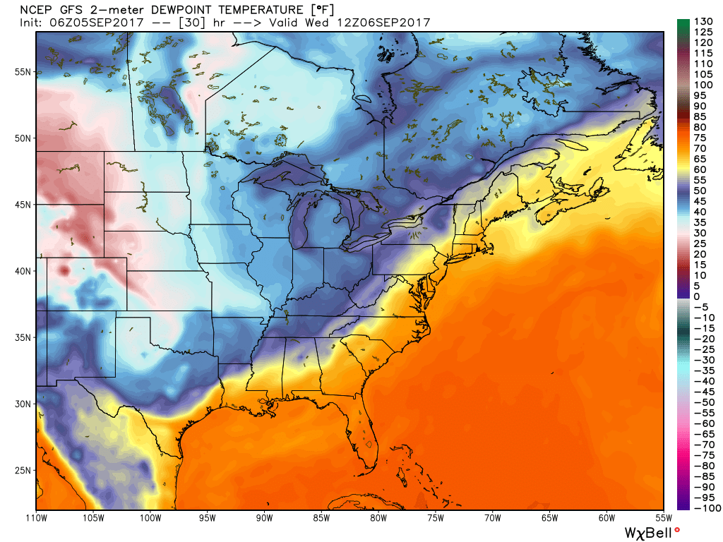
Cold front day! It’s almost like a holiday here in Houston. Moisture levels will increase a bit before the front moves through on Wednesday, most likely during the late morning or early afternoon hours. Some scattered showers are possible with the front—a few isolated areas could see as much as half an inch of rain—but for the most part this should be a breezy passage rather than one with thunder and lightning. Humidity should fall off a cliff after the front moves through, making for a pleasant evening.
Thursday through Sunday
We’ll have some great September weather after the front comes through, with highs generally in the mid- to upper-80s, overnight lows in the 60s (perhaps upper 50s for some inland areas and closer to 70 degrees along the coast). The drier air and full sunshine will feel fine.

Tropics
We remain in the midst of hurricane season, and during the overnight hours Hurricane Irma has become an extremely dangerous Category 5 storm. On Wednesday it will bring catastrophic conditions to the Virgin Islands and probably Puerto Rico, followed by the Dominican Republic and Turks and Caicos Islands on Thursday. By early this weekend it should reach Cuba. Thereafter the models diverge.
We have had lots of questions and concerns from readers about Irma’s track after this time, because the forecast models have continue to drift westward. Primarily, they are struggling to deal with a trough of low pressure over the United States and a ridge of high pressure over the Atlantic. Essentially, Irma will turn to the north when it finds the western edge of this high pressure system. The image below shows the forecast position for Irma on Friday morning, and potential tracks afterward.
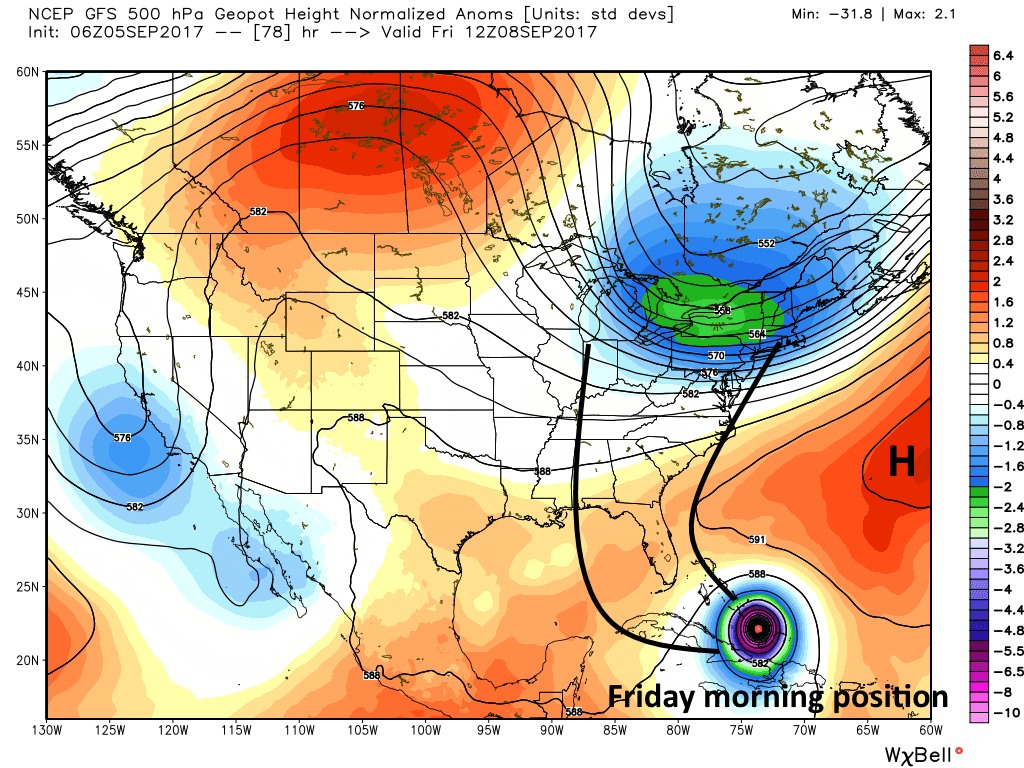
Although there has been some westward shift in the track forecast, we expect that this is about to stop. We have very good meteorological reasons to believe that Irma will make a northern turn, and stay out of the western Gulf of Mexico. And while almost nothing is 100 percent guaranteed in forecasting, we urge shell-shocked coastal residents in Texas to not have much concern for Irma. This may well be a devastating storm for the United States, but most likely it will be for areas such as the Florida Keys, Florida, and the southeastern United States.
Finally, it is also possible that a tropical storm will develop in the southern Gulf of Mexico during the next day or two, but Wednesday’s cold front should keep any effects from that system well away from the greater Houston area. Please continue to focus on recovering from Harvey—as it looks like Mother Nature will assist in that regard.
Morning Eric!
I think you still have Harvey on the brain in the last few paragraphs. Should change Harvey to Irma.
I did, thank you.
I think the United States should turn on the A/C on 60* and open all the doors. Seems like it’s worth a short. Sounds better then $100 billion plus
“we urge shell-shocked coastal residents in Texas to not have much concern for Harvey. ” you mean Irma ?
Several spots towards the end when you wrote “Harvey” inside of “Irma”.
Three references to Harvey. Harvey will forever be etched in Houston history.
Speaking of Harvey etched. We’re likely traveling to D.C. next week. I’ve been traumatized by Harvey- how concerned should I be about Irma reaching there? Thanks 🙂
I am also scheduled to head to D.C. Next Tuesday. Wondering about possible Irma impact?
Watch the system closely. It’s entirely possible DC will see no significant effects from the storm.
Thanks for all your help and updates! 🙂
I think your references to Harvey in the latter half of the post should say Irma?
Hey friends, just a heads up, it looks like you mistakenly referred to Irma as Harvey a few times throughout the forecast. Thanks for all you do!
Yes, sorry about that.
Hi,
Any chance this will follow an IKE track, if I remember IKE was going to curve North but did not, when it finally we were the target.
What is the big difference on IRMA?
Thanks for evertrhing
Monty
My family and me love your posts, thank you.
Just wanted to let you know that in regards to your comments about Irma, I think in the last three paragraphs the name “Irma” was replaced by “Harvey”.
Thanks for accurate and interesting information!
“we urge shell-shocked coastal residents in Texas to not have much concern for Harvey.” Unfortunate typo there. 😛
Yes, it was. Had Harvey on the brain this morning.
Those of us still suffering from “rain brain” thank you for continuing to do all the hard work! Praying for those in Irma’s path.
What’s the current projection for when Irma will start to affect Florida?
Hi Eric. I’m originally from Miami and my entire family still resides there. Can you elaborate a little more on Irma’s impact on South Florida – trying not to panic from afar but I keep thinking it’s going to be similar to Andrew.
Thanks as usual Eric! When Irma meets the western edge of the high pressure system, do you think that will have an effect on the intensity of the storm as well as the track?
High pressure should downgrade it, right Eric?
I’m supposed to send my son to Destin, FL with his grandparents on Friday. It’s looking more and more like I need to cancel this trip. Maybe tomorrow we’ll get a better idea on the track of the storm as to where it’ sturning.
Eric – We are currently on a cruise ship scheduled to be in Havana on Wed and Thurs, sea day Fri, and back to Tampa on Sat. We have a 12:50pm flight back to IAH on Sat. How concerned do I need to be about Irma?
Thanks for all of your good information!
Hi Eric, Do you have any recommendations for blogs/people to follow on Twitter for hype-free, accurate Irma updates? I am originally from South Florida and my parents still live there, so I’m quite concerned about the forecast. I really appreciated your work during Harvey and am struggling to wade through the nonsense and find similar coverage for South Florida.
Check Tropical Tidbits…Levi Cowen site…he is in FL but doesn’t focus on local area. Specific, thorough analysis…
This is awesome, thank you!
Yes! I’m in a similar siuation.
thank you for any advice!
Isn’t the low pressure system pulling it north the remnant of Harvey? That is, is Harvey ironically keeping Irma away from the Texas Gulf Coast?
Fianlly, no hype! Thanks y’all!