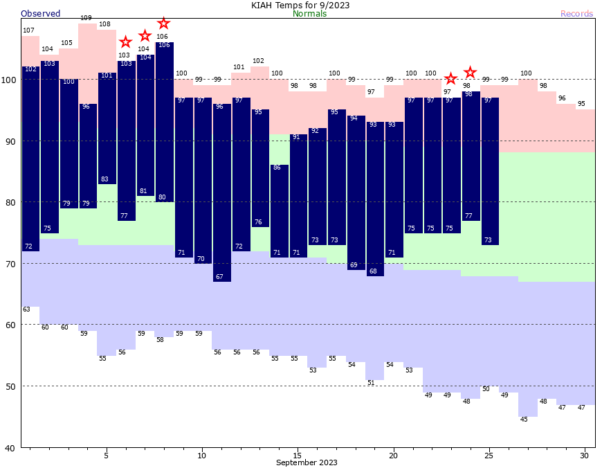
Good morning. Don’t look now, but Houston’s exceptionally hot summer continues. September is not yet over, but this month is on pace to—you guessed it—become the warmest September on record in Houston. The month’s average temperature is 85.6 degrees so far, which would smash the city’s record for September heat. Unfortunately, as you’ll see in the forecast below, our above-normal warmth will continue for some time.
This lingering heat has had all manner of negative effects, including on electricity bills for cooling your home. As part of our partnership with Reliant, I recently sat down with Reliant Energy’s Hosea James to discuss the incredible heat we experienced in the 2023 summer season, how that impacts customer electricity bills, and resources for assistance. You can watch the video here.

Wednesday
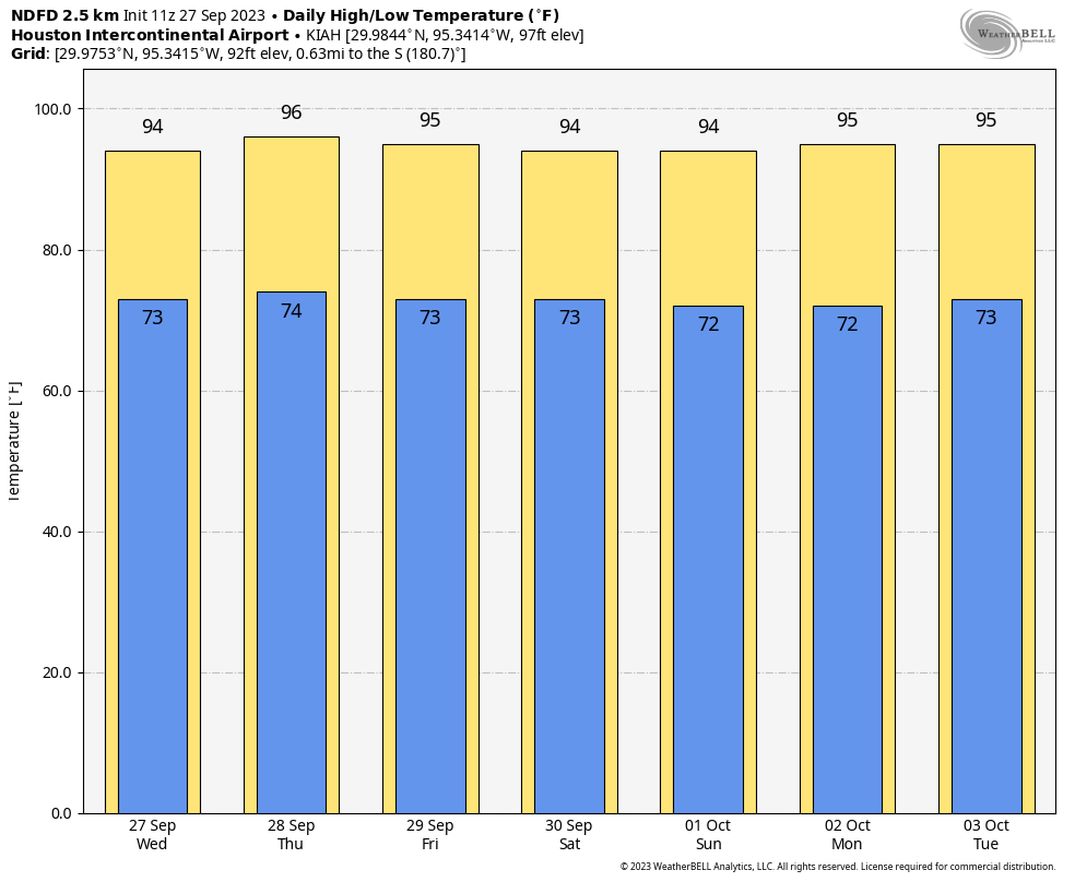
With a nearly stationary boundary offshore, Houston will see another day during which at least some scattered showers and a few thunderstorms should pop up during the afternoon and evening hours. Chances will be best closer to the coast, so perhaps 30 percent for areas south of Interstate 10, with a lesser likelihood for inland areas. High temperatures today should climb into the low to mid-90s, with mostly sunny skies and light northeasterly winds. Low temperatures tonight will drop into the mid-70s.
Thursday
Expect day a lot like Wednesday in terms of the overall setup, but rain chances will likely be a little bit less. Highs again will be in the low- to mid-90s.
Friday, Saturday, and Sunday
The pattern looks incredibly consistent over the weekend, with high pressure more or less in control of our weather. We’re going to see continued days with highs in the low- to mid-90s, sunny skies, and generally light winds. The influx of some slightly drier air will have several effects. It should shut down any meaningful rain chances, but it also will slightly lower the overall humidity levels. So the heat will feel a little bit more comfortable. (Emphasis on a little bit). Overnight lows will be in the lower 70s for most of the area.

Next week
There does not appear to be much change in this pattern for the first half of next week. After that? Well, the first opportunity for a cool front comes about 10 days from now, but again, it’s far from certain. It is fairly depressing to write this, so I can’t imagine what you’re thinking, but it does look like “late summer” is going to hold on for awhile, at least into the first week of October.
A note from Reliant
As Eric diligently reported, summer brought intense, unrelenting heat in Southeast Texas this year. While we may be out of this stretch of extraordinary temperatures, energy bills covering that time when ACs were working harder than ever are starting to arrive. Reliant prioritizes giving everyone access to the electricity they need to live comfortably. Anyone concerned about summer bills or needing payment assistance is encouraged to contact Reliant. We are here to help with agents available 24/7 via live phone support, online chat, or on the Reliant app.


“I used to love September, but now it just rhymes with remember.” -Dominic Riccitello
Ok, it’s not our typical September and it has not been our typical summer. But on the bright side, The highs are a minimum of 10 degrees cooler than they were a month ago and the lows are 5-7 degrees cooler. So we are trending, slowly towards our “normal”. And while extremely inconsistant across the area some of us have had some decent rains recently. So lets remain positive, El Niño normally brings us cooler and wetter weather.
& October not over – I guess that could apply to the new heat dome season…
will be soooooo glad when the cooler air arrives
🌬🍂🍂💜🍂🍂
Funny how each day Eric says cooler weather about 10 days out! When exactly is the 10 days? 🥵
Per The Eyewall “Fantasyland (beyond day 10)”
September is usually really hot, not surprised. First of October is usually pretty warm too. Cool fronts can make it down by Halloween, which is either really warm or really cool, seems to always be an extreme. I have conditioned myself to not get excited about really cool air until November. That’s just the way it is in Houston. We need more rain, however, this dust is killing me!
While true that Septembers are usually quite warm and at times hot, this particular September is hotter than all others from the past ~130 years of Houston record keeping.
I thought El Nino years were supposed to be cooler and wetter in our neck of the woods. This one is turning out to be a dud so far.
I don’t know man, but as a native I’ve seen plenty of thanksgivings and Christmases that were in the high 80s. I’ll believe it when I see it. ☹️
Agree. We’ve had summer annuals last all winter numerous times. Though not in the last couple of years. Not unusual to see the kids trick or treating while sweating like a marathon runner
My prediction is that temps will continue to be depressingly well above average until late December, we’ll get about two weeks of actual winter in January, then summer returns no later than mid March.
Ashley, Richard, kdn, you’re all spot on. I recently saw some old family movies (transferred into digital media) of my cousins and me running around in shorts on a Christmas Day several decades ago. That 2004 Christmas Eve snow seems like a hallucinatory false memory to me now.
Did you forget how cold it was around Christmas last year?
Record question: are we currently under the longest sustained high pressure system without a major low pressure system to break it down? We have certainly had a couple of weak low pressure systems since late Spring, but I feel like this “heat dome” has been firmly in place for much longer than is normal for anywhere I have lived.
There was a high pressure system nicknamed the “Ridiculously Resilient Ridge” that hung around the eastern Pacific Ocean for four straight years from ’11-’15. It caused severe drought all along the American and Canadian coasts.
Joseph is the pattern historian and answered this a couple weeks ago. Seems these can hang around awhile until planetary axial tilt puts us too far north to matter. Could need another 10 deg tilt from Sol to kill it over TX. Winter Solstice is 23 deg beyond Sept 21. We’ll just have to see. Ocean volcano water vapor and lack of reflective aerosols seem to be getting some press too. I’m thinking the “ridiculous”ridge in the Pacific was related to one of the other climate oscillations (not ENSO)
Yes there definitely are other factors that controls the upper air patterns. One of them is the Arctic Oscillation. There is 2 phases of the AO. The positive phase and the negative phase. The positive phase is when you have a large upper level low stalled out over the northeast Pacific Ocean just nearby or over the West Coast. This typically causes the jet stream winds to travel in a west to east direction over the United States also known as a zonal flow. This keeps the cold air locked up north and the warm tropical air stuck over the southern states. This is usually what causes our warm spells during the winter. During the negative phase, a upper level high pressure ridge shifts over the same area which causes the jet stream to dip sharply to the south sending cold Canadian and sometimes Arctic air straight through Texas. In extreme cases we end up with what we saw in February 2021. We usually shift between both phases during any given winter, but some years we get stuck under one phase much longer than the other. The sea surface temperatures of the Pacific along the Northwest coast is one factor that can influence the AO. I’ve also read that solar activity could have an influence as well. The ESNO usually dictates the long term trend throughout the seasons, however some years the AO has more influence on our Winters than the ESNO does. Plus other not very well understood factors as well.
There is also the North Atlantic Oscillation that can affect our weather as well but that’s a topic for another day. Unfortunately we can see this upper level heat ridge return repeatedly even during the late fall and winter as well. Albeit it’s not August type heat but it can keep us much warmer than usual even during the cold season. This is what caused the first half of last December to be stuck in 80s. I have my fingers crossed that the opposite happens this year. 🤞🤞
Wow, 90’s as far as the eye can see =(
Some years in Houston, summer transitions right into winter with very few nice fall days. I hope this year is not one of those years.
I have been alive since the early 80s… and I’ve NEVER seen temperatures hit the 40s in September. Is this real? Forty-five degrees on September 27th?
September 27th, 1942
49deg. Sep.22nd 1983
Year 2000?
Yep. We had a record low of 49 on September 26th 2000 which is pretty ironic given that we saw the infamous record Labor Day Heatwave earlier that same month when Houston first reached 109 for the first time in history on the 4th.
This is perfect weather, if the whole year could be like this it would be great.
Depressing to write, depressing to read, depressing that fall is just a fantasy we need 🙂
Does anyone know when “fall day” occurred in 2011?
Per the old climate records, there was a front that brought the low temperature down to 59 degrees on an astonishingly early September 6th, 2011 cool front (though the highs were still in the 90s). The first front that brought highs down to the 80’s and lows down to the 50’s consistently that year was right around September 30th/October 1st. Either way, it seems like we’re behind even 2011 this year. 🙁
In another bit of trivia, I think the latest that “fall day” has occurred in recent memory was 2018, when it finally officially happened on about October 11. Prior to that, you have to go back to around 1900 or so to find a fall day that late. I really hope we don’t break that record this year.
How about 50s October 9th
https://www.tropicaltidbits.com/analysis/models/gfs/2023092712/gfs_T2m_us_49.png
A few of us just want rain. You know. All day. Like on a Sunday. Other places not named Sahara or Arizona have that. Why can’t we.
When might you have a Wings Over Houston forecast? I’d hate to bake through another one all day. Wish they could have it in November.
I don’t think we can rely on a nice long winter/spring season. Historically Feb 24 in 2021 had a high of 80, on Feb 24 2022 it was 50, but a month later in 2022 it was 70 and another two weeks it was 86. We are all doomed to fry!