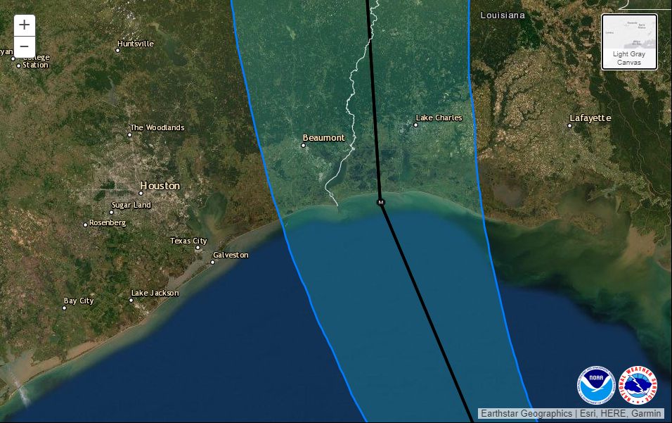
POSTED AT 10:30 AM CT WEDNESDAY: Just a quick, mid-morning update to share the latest information from the National Hurricane Center, and drill down a little bit more into what you should expect tonight, and when, in the Houston area. The storm has unfortunately continued to intensify, now up to 125 mph, and the hurricane center predicts Laura will come ashore as an extremely powerful hurricane with 145 mph winds tonight just east of the Texas-Louisiana border. Forecasters had this sober message for coastal residents near the landfalling storm: “Unsurvivable storm surge with large and destructive waves will cause catastrophic damage from Sea Rim State Park, Texas, to Intracoastal City, Louisiana, including Calcasieu and Sabine Lakes. This surge could penetrate up to 30 miles inland.”
Closer to home, right along the coast, the biggest impact will be storm surge. However, forecasters have backed off their expectations for the Galveston area, slightly, with 2 to 4 feet of surge now anticipated. We still expect low-lying areas on Galveston Island and Bolivar Peninsula to be inundated with water for several hours tonight. Storm surge will get incrementally worse up the Texas coast, and reach its peak east of Laura’s landfall, in Louisiana.
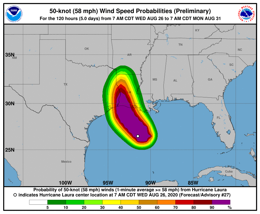
For everyone else, it’s going to be almost all about the wind. Some areas of town are already seeing breezy winds from the northeast, with recent gusts of about 20 mph reported at Hobby Airport. These winds will build this afternoon and evening and likely peak from about 9 pm through 3 am. I anticipate the potential for Tropical Storm-force wind gusts for at least the eastern half of the metro area, with the greatest risk right along the coast. (The National Hurricane Center estimates there is a 6 percent chance of hurricane-force winds in Galveston, and a 21 percent chance in High Island).
This morning I mentioned the widespread outages during Hurricane Rita for the Houston metro area. I think that remains the biggest potential for disruption tonight, and you ought to be prepared for at least a short outage. But quite frankly, the storm is now tracking slightly east of where Hurricane Rita came ashore in 2005, and will be turning away from Houston. Yes, Laura is more powerful, but we are nonetheless getting further from its core of stronger winds. This eastward movement may also spare Beaumont and Port Arthur from the storm’s very worst effects, but it is still going to be most dicey. We hope to have better information on this later today.
In terms of rainfall we have no real concerns. There may be some briefly heavy downpours, but the region’s bayous are dry. Accumulations of less than 1 inch are likely west of Interstate 45, with 1 to 4 inches possible on the east side of town, increasing as one nears Beaumont.
Rains and winds from Laura should be rapidly moving away from the Houston area by Thursday morning. Rain chances will linger through the remainder of the week, but it really should be nothing to worry about.
Our next update will come no later than 2:30pm CT.

When can we expect to see the slight turn to NNW?
Strange, I don’t remember losing power after Rita, and I got back the afternoon after landfall.
You were lucky. My neighborhood in Clear Lake lost power for a couple days. Houston’s power grid is kind of weird; I’ve lost power on my side of the street and the other side was fine.
I stayed home during Rita and only lost power for a few minutes, I think.
We stayed home as well and lost power for about 5-7 hours.
Some parts of the Cleveland area was without power for more than 10 days after Rita. Myself included.
Rita was so strange. I worked in Humble and East Mintgomery County. It was as though 59 was some sort of barrier. West side of 59 did OK, but the east side lost power for a couple of weeks. All along 59. So crazy.
Right now though, I’m praying like hell for the folks in Port Arthur, Orange, Beaumont and east into Louisiana. May they all be safe and may this beast lose strength before landfall.
We were without power for about 5 days after Rita
We lost power for 12 days after Rita. West part of Houston. Bad luck, I guess.
We lost power here in Sugar Land for about 18 hours. Just a gust we didn’t even notice right as storm was coming onshore knocked us out. Literally nothing. So candles on the ready for tonite
Where can we find information posted so we can donate to help those negatively impacted?
I’d imagine that many of the same orgs that helped whenever things like this happen (Red Cross, etc.) are already ready to accept donations. More localized opportunities will pop up everywhere once the storm passes through and damage can be assessed.
It may be worth waiting on the local charities through the first few days to gauge who is best positioned to push the most funds to the most people most effectively, and contributing to the nationals that can spin up initial efforts.
I’d contribute to local charities before I give to the Red Cross.
UMCOR sends all donations directly to those impacted. No other organization does this!
Very true, Neil. Local is oftentimes the best way to go. Just be sure the organization is legit.
Google the Cajun Navy. They are volunteers and go where and when many other organizations don’t. They do more than anyone would expect anyone else to do. They are heroes…and many of them will be in the path of destruction themselves. I believe they have a way to donate funds for food, supplies, fuel, etc…
The Cajun Navy is the way to go. Do not donate to Red Cross or United Way. Red Cross charges for a cup of coffee in disaster areas. United Way donates very few dollars to those in need.
Your local United Way would be your best bet. In the past, Harvey included, the Red Cross was incredibly inefficient and there was a lot of financial mishandlings. I’d go local -like your local food bank and Charity Navigator verified charities in your area.
Agreed. Red Cross did not provide us any assistance although we requested it several times after our house flooded.
4bresponse.org is helpful and has helped several local families, including us, since Harvey.
Redcross and Salvation Army was in full force down in San Patricio after Hurricane Harvey for weeks providing supplies and food to citizens in low income areas. I saw them first hand when I went down to help affected family members during the aftermath. Houston Food Bank is always in need of assistance and serves a huge area that may be impacted by the storm. It may be a good idea to see where the storm ends up landing and the damage it causes then decide to donate to those affected.
What effect will Laura have on the Gulf water temperatures? Will it make a significant dent in the potential hurricane fuel?
Also great job Matt and Eric. There’s no avoiding being scared and anxious when a big storm approaches, but honest and accurate weather forecasts help so much.
That’s a great question!!
Thank you for your posts; I rely upon you and Matt entirely for information about Laura as well as instructions as to how I should prepare for the hurricane. Kudos.
Thank you for both of your vigilance in keeping us informed. You tell it like it is in a way that makes perfect sense. I do not pay attention to anyone else.
Thank you both so much for your almost perfect weather forecast/predictions. Y’all are incredible!
What effects will Beaumont experience?
The longer this storm goes, the more thankful I am that it is not going to be making landfall around Galveston. We have dodged a bazooka. And thank you Eric and Matt for the continual fact-filled updates.
Any predictions of what to expect in the Huntsville/Trinity area. Thank you!
24hours after Rita made landfall, a limb fell on our transformer and we were without power for a week.
As others have noted, the Houston metro area is dodging a gigantic bullet here. But, after thanking my lucky stars for a minute, I’m mindful of the damage that will be happening to our neighbors to the east.
They will need our help in the coming days so please consider giving to a worthy charity that will help them directly and locally. From our experience with Harvey, a week is a very long time after a natural disaster.
Great Job Guys‼️ Thank You so Much‼️👍👍👍
I want to echo some other thoughts here. While I breathe a sigh of relief for all of us in Houston, I still worry about all our friends out in Beaumont. They seem to get pummeled by every storm that comes near. I also pray for all of those in the Lake Charles area, especially the coastal areas near and east of there. There obviously is going to be widespread destruction. Mercifully this storm is missing highly populated areas, but let’s not forget there are going to be so many whose lives are upended by this storm.
My sister is Kerrville, Tx and she just heard on CNN that the hurricane was heading for Houston and that it would be devastated. The towers downtown are going to be completely destroyed and on and on. Amazing and sad.
Unbelievable take-away.
Does your sister tend to drink early in the day?
I wish people would stop asking about their particular neighborhood. Matt and Eric have enough to do with the BIG picture. and….if some people would read the actual post they might be able to glean what is possibly going to happen in their Wood Wood subdivision. Read it again….POSSIBLY going to happen. No one knows but God.
I think they may be asking the wisdom of the crowds as much as they are asking Eric and Matt. It can get a bit repetitive, but its better that people ask and learn rather than sit in ignorance.
I’m sure some of those asking are doing so because they are too lazy to read the post, but I can’t tell which those are, and so I assume that it is one of those that I’m not reading at the moment.
Thank you very well written and hopeful with appropriate caution
Been trying to get into the Cajun Navy website to donate but can’t get in
I have always been extremely nervous about hurricanes, most recently due to Harvey flooding of my home. I tend to “over-prepare”. A friend told me about your website, and have since found that it is very highly regarded by many people, including my HOA. I live in west Houston. Your clear, non-hype, honest explanation of the situation has been so helpful, even when you could not give as accurate a forecast as you would have wanted. Even when there was a possibility of impact on us, I still felt confident and hopeful.
While I’m relieved for those of us in the Houston area, my heart breaks for those in LA and up into Arkansas. Prayers for your safety. Thank you again Eric and Matt! Y’all deserve a beer!
And now I see another yellow blob in the Atlantic to look out for..I think I heard chatter that it was gonna be a fish storm though..