Good evening. I’d like to welcome our new readers to the site—whether you found us through a friend or family member, Google, Facebook, Twitter, Instagram, or of course our MySpace page. Just kidding about the last one, sorry Tom. Anyway, if you don’t want to miss our updates, you can subscribe to our email list in the box on this page. Doing so sends you our complete posts immediately after publication (and nothing else).
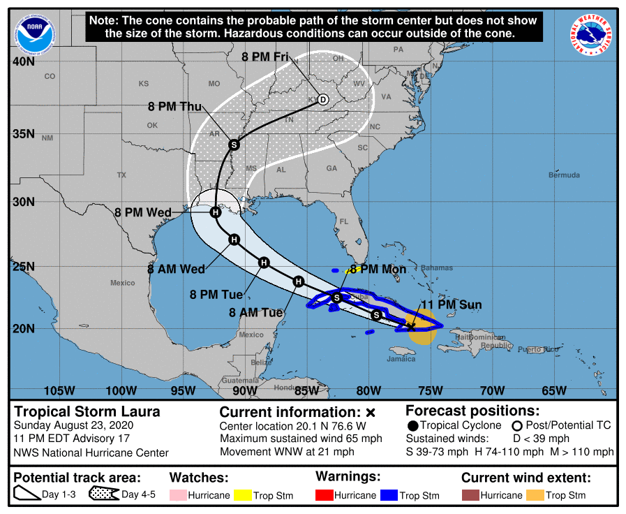
Alright, on to the forecast. We’re still really struggling with the evolution of Tropical Storm Laura, and a large part of the uncertainty involves the movement of its center over, or just south of Cuba the next day or so. Laura does not have a particularly well defined center and its interaction with the island may cause the center to re-form. Any of these perturbations could have implications for the storm’s track downstream. This is one reason why the models are struggling with how to handle Laura’s ultimate path.
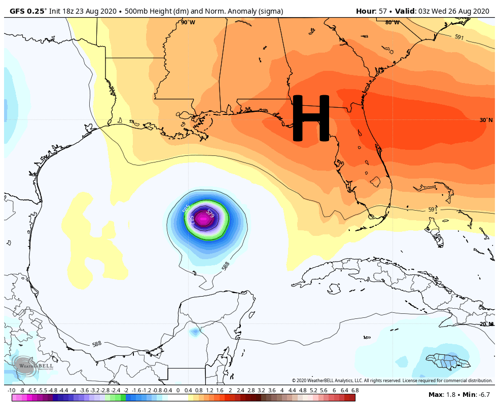
Another factor is Marco, which we still don’t think will have a sensible effect on weather in the Houston metro area. It seems likely that a “stronger” Marco, maintaining hurricane strength on Monday as it nears the Louisiana coast, would amplify a ridge of high pressure over the southeastern United States. This would push Laura more westward, toward Texas. However, a weaker Marco would probably allow for Laura to follow a more northwest track across the Gulf of Mexico, toward Louisiana. These, and more details, are the reasons why overall confidence in Laura’s track remains low. Because of this uncertainty I thought it might be helpful to outline three scenarios that I think are possible, along with their likelihood of happening.
Scenario One (30 percent)
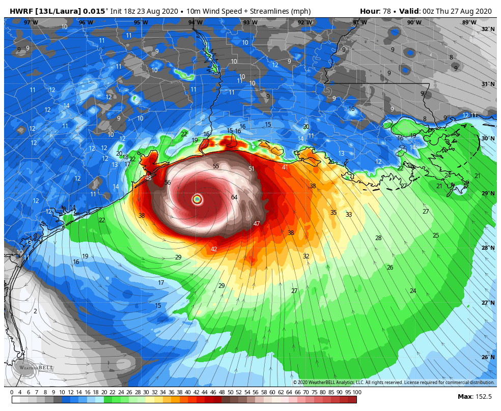
In this scenario the ridge of high pressure remains strong, and drives Laura toward Matagorda Bay or Galveston Bay very late on Wednesday, or early Thursday. This would allow for maximum time over the warm Gulf of Mexico, and we could see Laura coming ashore as a powerful Category 2, 3, or even 4 hurricane. This obviously would be a very bad deal for Galveston, Houston, and points east in terms of storm surge and winds. This would necessitate coastal evacuations and lead to widespread power outages, among other problems. Rainfall would be less of a concern because we expect Laura to scoot through fairly rapidly.
Scenario Two (50 percent)
In this scenario, which is basically the “skinny black line” on the National Hurricane Center’s forecast, a reasonably strong Category 2 Hurricane comes ashore near the Texas-Louisiana border, or just east of there. In this scenario Houston sees some briefly gnarly winds, possibly gusting to hurricane force on the east side of the city. But beyond some relatively short-lived power outages, conditions should not be too extreme in the metro area. This would, of course, be a bad storm for Beaumont and southwestern Louisiana.
Scenario Three (20 percent)
In this case Laura comes off Cuba and begins moving almost due northwest, toward New Orleans and southeastern Louisiana by late Tuesday night or Wednesday morning. With less time over the Gulf this is a weaker storm. Houston would see almost no significant impacts from such a scenario, but it could cause significant surges or flooding in New Orleans, Mississippi and Alabama.
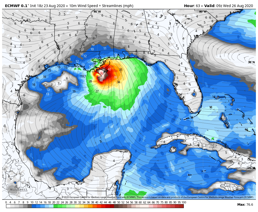
For the last two runs the deterministic output from the European model has more or less depicted this third scenario, along with the Canadian model. For this reason we can’t entirely discount it.
We hope to have better answers for you tomorrow on all of this, when we’re going to reach the point when final decisions on evacuation and other preparation activities will need to be made for the metro area.
Our next update will be no later than 8:30 am CT.

Praying for scenario three, preparing for scenario one.
Same here. Today was spent trimming back anything that could possibly bash against the house during high winds. I’m tired but doing something has its benefits.
As always Matt and Eric rock!
We did the same this weekend. As prepared as we can be.
Count me on the “let’s have scenario #3 but prep for scenario #1” plan.
I’ve told my mother that she should know this routine down cold since she’s lived here for over 50 years. We’ve been through Hurricane Alicia, TS Allison, Hurricanes Ike, and Harvey. Even non-named storms cause trouble like the Memorial Day floods and Tax Day floods.
But, the time to prepare was really this weekend, along with the “get the heck out” bag so that one can avoid panic. No need to freak out: just keep up with Eric and Matt’s reports here and prepare quietly.
Solid Sunday night entry, Eric. All the hopes for everyone.
Thank you Eric and Matt for keeping me sane!
I second this!
As always, thank you for the facts. I have stocked up on water, food, flashlights, dog food and most importantly WINE. I truly appreciate the both of you.
I will sleep better tonight- thank you
Thank you. I turn people on to ya’ll and they are like, What did Eric and Matt say?
Hah!
Do you guys stay at one place and work on these forecasts? Is there a casserole or two for y’all?
Being in Katy, I’m fine with whatever, I think
This sounds like the Corpus area is now off the table?
Hope so, reading this in N. Padre Island.
THANK YOU FOR YOU DILIGENCE
“I have my civil defense helmet and beer, I’m good” – Lanny Griffith
Have guys overlapped the tracks of the 2 storms? it looks like Laura will hit at the same time the remnants of Marco. Idk if anyone has taken that into account
Everyone shut up………….does Katy need to evacuate?
People walk their dogs in the morning of a hurricane hits…do they need to postpone their dog walking? I ask because dogs are more important than humans. Dogs lifespan is less than a humans, therefore dogs are more important. Yes they lock their privates and don’t contribute to society. Dogs are way more important than humans!!! My dogs!!!!!!!!!!
With as often as Europe has been right the last few years, can you help me understand why Scenario 1 has a higher probability than 3?
I’m also not clear on this. They say it’s the least likely scenario, but cite several repeated predictions. I don’t understand why it gets 20% weight while the mass destruction of Houston gets 30%.
The EURO hasn’t done well this year with the other storms.
Houston is now out of the cone of uncertainty. I hope there is no major adjustment like there was with Marco. It probably will because of 2020 and Houston is cursed.
Keep in mind the cone only covers 2/3 of the historic error range. So Eric’s 30% is a bit higher than the NHC’s ~1/6 but with either # it’s worth being prepared.
Hopefully we wake up to this continuing eastward trend for Laura. Looking forward to the next update with better news.
Thank you so much for keeping us posted! Love your very helpful and honest information.