It’s very humid this morning with relative humidity above 90 percent in may areas. It seems too early for low temperatures to only fall into the upper 60s, but such is life I suppose.
TODAY
We’re going to remain in this stagnant, humid pattern today and Friday, but with the added possibility of rain showers. There’s a lot of moisture in the atmosphere right now, but it’s going to be difficult to time when the rain occurs. My best guess is that we will see some scattered light to moderate rain later this afternoon and evening across the Houston area that coincides with daytime heating. Temperatures will climb to about 80 degrees.
FRIDAY
There’s a better chance of rain on Friday, especially later in the day. High resolution forecast models show a break in shower activity during the morning hours, but with all the moisture in the atmosphere that’s hard to say for sure. What does seem likely is that heavier rain showers are unlikely to develop before Friday evening, and then may occur during the overnight hours. I do not anticipate more than 1 inch for most areas locally, but some isolated areas could see 2 to 3 inches.
SATURDAY
The rains will end Saturday morning sometime as a stronger cold front moves in. Winds should be brisk out of the north during the pre-noon hours, but moderate a little in the afternoon as skies begin to clear. Highs should remain in the 60s.
SUNDAY and MONDAY
We’re still on track for a couple of sunny, gorgeous days on Sunday and Monday with cool mornings in the 40s to low 50s, and highs in the upper 60s or so.
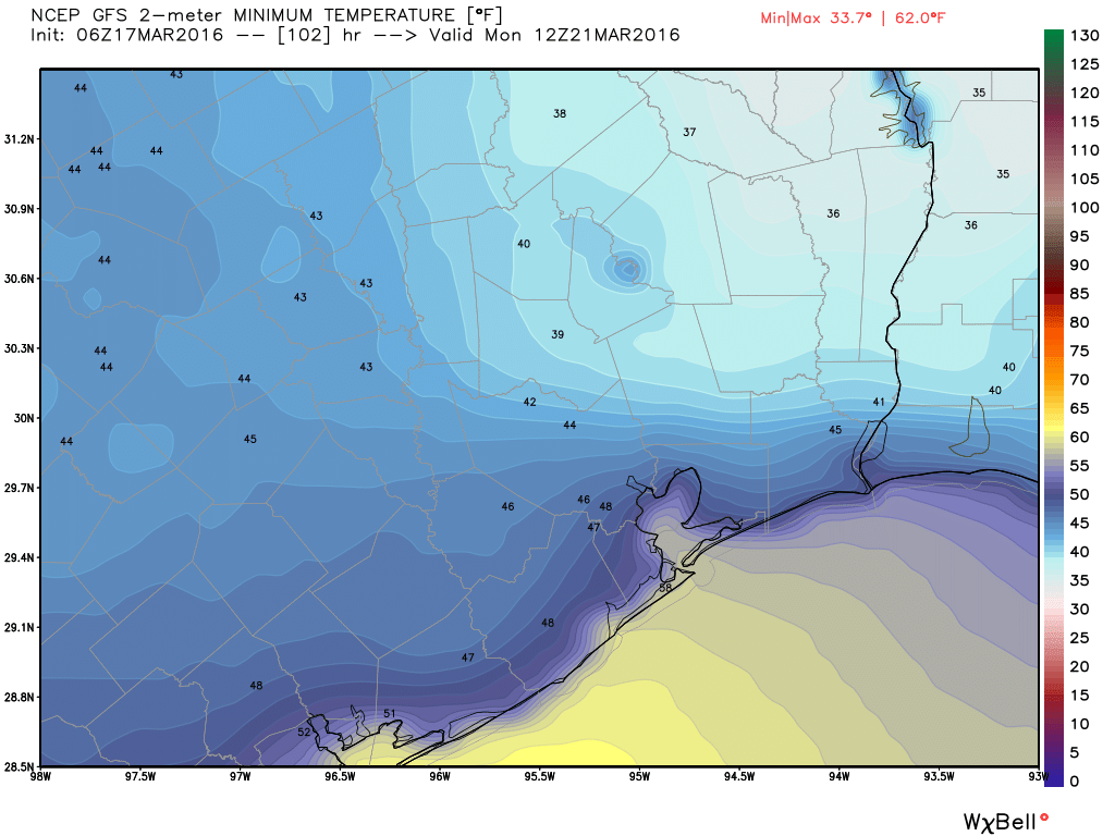
Monday morning will probably be the region’s coldest temperature since late February, and I’m not sure how many more mornings we’ll get in the low- to mid-40s until next fall. So enjoy.
TUESDAY and BEYOND
We’ll see the return of Gulf moisture later next week, and that may set us up for some storms toward the end of the work week.
Eric –
We’re supposed to drive to Gulfport, MS this weekend. Any thoughts on whether the continuing rain will increase flooding on the Sabine? Not holding out hope for an 1-10 crossing.
It will not help, Erin, but the question is out on how much it will hurt. But the damage may already be done in terms of I-10 for this weekend so it may not matter much.
When I look on Google Maps it looks like the beach road at the coast where TX and LA meet is still open. This assessment is based on seeing live traffic colors on the map. As to whether you can get through Orange to actually cross on the beach road is questionable. But it would save you and many others the 10 hours it will take to detour via Shreveport.
We’ve taken this road many times between TX and LA. It’s deserted, fun, and peaceful. Oh, and there’s a ferry between Holly Beach and Cameron, LA. You might want to check if it’s open, otherwise it’s a long detour north to Sulfur. You can also see the Cheniere LNG plant, first in the nation to export natural gas just a few weeks ago.
Already drizzling on the Ship Channel.
Looking forward to one last visit with the 40s. Bedroom windows will be open.
Even the winters are getting to be too warm for me here.
You said there is a possibility of rain showers at the end of next work week. How accurate is that? Going camping near Austin next weekend and hoping to get a weather forecast before I made a decision.
There is a front moving through Texas, most likely, sometime late next week on Thursday or maybe Friday. It has a chance of bringing some rain. That rain will probably end by Friday night or Saturday in central Texas, if it occurs at all. It is not possible to be more specific than that.