Good morning. Houston’s wet pattern will continue through the work week, although the most organized heavy rainfall should wind down over the course of this morning after a storm system pushes through the area. Please take care if you have cause to be out and about this morning before conditions should improve later today.
Wednesday
Moisture continues to move in from the Gulf, combining with an upper-level storm system to bring heavy rains to the metro area on Wednesday morning. The heaviest rains are generally to the south of the city now, and this mess should slowly begin to slide generally eastward, exiting the area entirely by 9 a.m. or 10 a.m. In the meantime, these storms should put a manageable 1 to 3 inches of rain down for most of the metro area—with the heaviest rains coming and lingering near the coast.
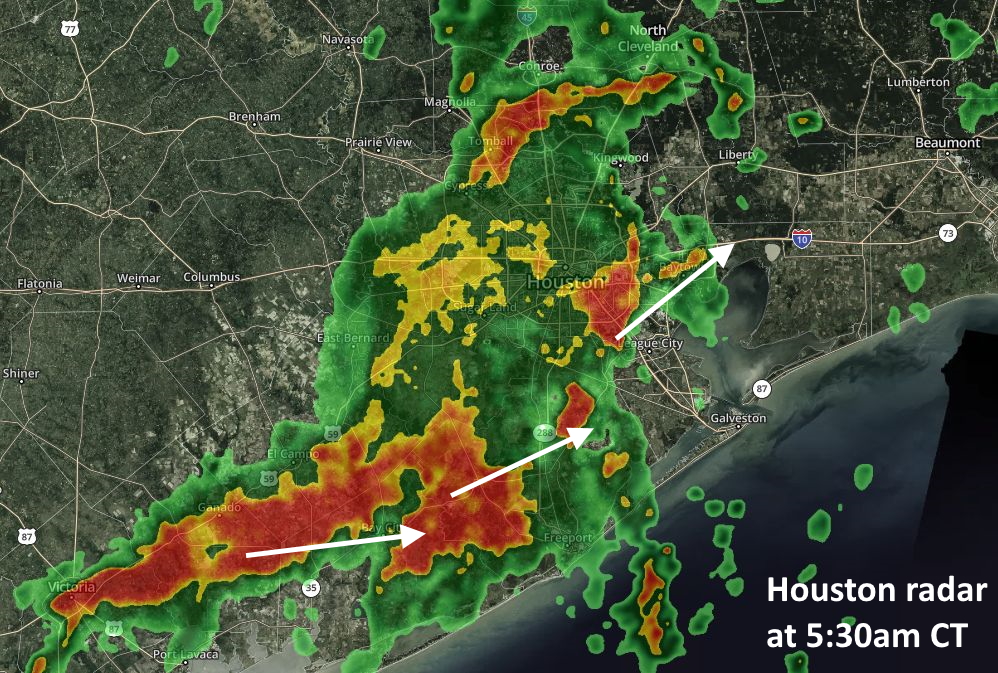
Although this will end our Stage 1 flood event, the rain won’t be over. Even as the storm system rotates away from Houston, additional moisture will be pulled inland and more showers will likely develop this afternoon. We’re not sure about this, because the atmosphere should be somewhat stabilized after this morning. In any case, storms this afternoon should be less organized. Highs today will likely only reach the mid-80s with cloud cover and rain.
Thursday
Healthy rain chances continue on Thursday, with a higher likelihood of moderate-to-heavy rain along the coast where moisture levels should be highest. Accumulations should be less than on Wednesday, however. Temperatures should remain in the upper 80s for most with cloudy skies.

Friday
As moisture lingers, we’re going to see another day with pretty decent rain chances—probably around 50 percent—for the metro area. But drier air should finally arrive later in the day and overnight hours to dissipate any activity.
Saturday and Sunday
The weekend forecast remains complex as a fairly deep layer of Saharan dust moves into the area. This should help to limit—but not entirely eliminate—rain chances on Saturday and Sunday. The bigger question is how much dust affects visibility.
In Puerto Rico, on Tuesday, the dust reduced visibility on an otherwise clear day to 3 miles. According to climate scientist Brian Brettschneider, here are no cases of sub–4 mile visibility since the early 1950s due to haze in the summer months. The plume of dust may weaken some as it continues to progress westward over the Gulf of Mexico, toward Texas, but it is likely to remain potent enough to cause similar visibility issues here. This likely will also exacerbate allergy and respiratory issues. Highs this weekend will be around 90 degrees, with some sunshine and some clouds.
Next week
As high pressure builds in next week, we expect to see skies become more sunny, and temperatures to rise into the low- and then mid-90s. Rain chances aren’t going away entirely, but for the most part any showers that develop likely will do so during the afternoon hours, and be fleeting. Early July will feel like, well, early July in Houston.
We got very little rain here in Katy. Was expecting a torrent.
Welcome home mosquito! I’ve missed you so!
Yes. Permanently. Growing too much. Scat!
Morning gentlemen, Katy sends it’s regards. Lol
I guess you were right after all regarding this morning.:)
Most of the area has gotten a good soaking over the last few days. It is okay to put a pause on this for a while but my AC would love the easier time when it is “cooler”. Is it fall yet?
I have definitely begun the fall countdown in my head. I know a lot of folks love it when it’s hot outside, but that’s about the only thing I don’t like about Texas.
Maybe you guys should move your models up 60 miles to the north. Seems to be a pattern over the last four months when you forecast severe weather.
Assuming the tropics are very quiet?
Re Fall. I was ready for it 3 weeks ago. I don’t mind the heat, but it lasts so long.
Looking at the Weather Underground nexrad radar at 10:30 A it looks like closed circulation over Houston NE Harris County. ?
Do you guys have anymore info on the dust coming? Being asthmatic I would love to hear more of your view verses the media. Thanks!