After a dreary Monday, we’re starting off with a dreary Tuesday now. But! I do think there is more sunshine “risk” in the forecast today and tomorrow. Let’s discuss.
Today
There are Dense Fog Advisories posted west and north of Houston this morning and along the immediate coast, as visibilities have dropped overnight.
Most of Harris County is not dealing with fog, except near the bay. Galveston is at a half-mile, as are parts of Liberty County, the Brazos Valley, and areas west of about Katy. As fog dissipates later this morning and afternoon, look for mostly cloudy skies. Hopefully some sunshine, but I think tomorrow has the better chance. A shower, downpour, or stray thunderstorm cannot be ruled out today. Temperatures this afternoon should get close to 80 under cloud cover, or perhaps into the low-80s with sunshine.
If you’re going to check out NCT 127 tonight at the rodeo, temperatures should drop from the  mid-70s early this evening to near 70 by 9 or 10 PM. It will be humid, and it could be a foggy drive home for you, so make sure you’re able to take a little extra time heading home from the rodeo festivities.
Tonight & Wednesday
Look for dense to again develop this evening in spots, probably before midnight. Fog may be a bit more widespread tonight and tomorrow, and it will linger through at least mid-morning on Wednesday. All areas should clear out a good bit Wednesday afternoon, except for the immediate coast, where fog could drift in and out through the day. With some sunshine, I see no issues with us pushing back toward 80 or into the low-80s on Wednesday afternoon.

Thursday & Friday
Things settle into a groove here: Clouds, maybe some sun (mostly Thursday), and the likelihood of varying degrees of nighttime and early morning fog. Rain chances are low but not quite zero. There was one model trying to push a front through on Friday, but that has since backed down. I think it’s like that the front is going to remain stuck up north of the region, so I expect temperatures to be in the 60s in the morning and lower-80s or upper-70s in the afternoon on both days.
Weekend
There is a good deal of uncertainty on forecast specifics this coming weekend unfortunately. It all hinges on how close the front in North Texas gets. My sense right now is that we should see increasing rain chances this weekend, particularly by Sunday. How much rain? Heavy rain? Strong storms? All questions to be answered in time. But I am leaning toward more hit or miss type scattered showers this weekend. Outside of that, I would expect warm temperatures, a continuation of clouds, sun, and patchy morning fog, especially at the coast. More on this tomorrow.
Answering some weather questions!
Over the weekend, I posed a question to Twitter looking for some weather questions to answer. With a fairly stagnant forecast this week, I’ve got a few extra minutes to answer some questions, and I’ll do that at the bottom of posts in the coming days as I can. If you have one, drop it in the comments. I certainly can’t promise I’ll get to the question, but I will absolutely try. Let’s go to the phones!
Is there more temperature / wind strength / humidity swings this past year than, say, various years in the 1990’s? I have always gotten sick when the weather makes sharp changes, and this year has been particularly difficult.
— Aaron (@MoogleSpace) March 7, 2020
So this is a good one. Now, I can’t answer statistically on the wind/humidity aspect of things, but I can speak somewhat to temperatures. One thing I like to track is volatility in temperature from month to month or season to season. Basically, I just take each day’s mean temperatures and calculate the standard deviation of all the values over the period. The higher that number, the greater the “volatility” of the period. For example, this past winter (defined as December through February) was actually one of the least volatile on record (back to at least the winter of 1940-41).
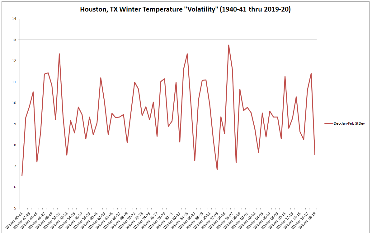
It looks like there have only been about 6 other winters with less volatile temperatures.The winter of 2017-18 was actually one of the more volatile winters in recent memory, but the last two have not been that wild. Compared to the 1990s, there’s honestly not a lot of difference in recent volatility, and the long-term trendline for winter at least is pretty flat. Now, if we ran this analysis for autumn, we’d get a more volatile picture back in September through November 2019, but still not quite ultra high. As far as the past full year goes, I have not yet run that analysis, but based on a quick look, I imagine it would not be drastically more volatile than a typical year.
I will say anecdotally that I had the same thought as the reader here and expected a different outcome. I do wonder if the range of temperature swings has narrowed a bit because it’s been very warm in recent weeks. So instead of going from 70s to 30s and 40s frequently, we’re going from 70s to 40s and 50s more often. In that case, you’d see less volatility statistically, but you would still suffer basically the same effects.
I got one. No throwing stones, and I follow you guys so obviously not a hater. It seems recently predicted rain events by all sources in the HOU area have been MUCH drier than predicted. What’s the deal? Models off? Climate change? Democrats😜?
— The Soggy Koozie (@OffTheWallRacin) March 7, 2020
Actually, aliens! Snark aside, this follower is correct in that recent rain events have been a little more difficult than usual to pin down! This winter has been exhausting at times in terms of how modeling has handled cold fronts, both timing and intensity. This has actual rippled out in time and and across all models: I look at medium range weather forecasts as part of my day job in the energy industry, and there have been an abnormally significant number of changes in the 7-10 day+ window. Not just the usual noise, something a lot worse than that.
I can’t answer the follower’s question with any specificity at this time. I’m just going off what I have seen this year, and it’s fairly complex. Models already handled precipitation outlooks with mixed success. Some days those forecasts feel more like art than science. That said, the models have been tweaked a good bit in recent years, with the intent of improvement. And statistically, they have improved. This winter, however, has seen a persistent and really strong to near-record strong polar vortex bottling up cold air at the North Pole. Additionally, there have been a good bit of extreme conditions in the Indian Ocean region. These areas tend to help drive some of the weather we see over North America. And this winter, with extremes in those regions, something about the modeling seems to have broken down. Models do a somewhat decent job handling individual extreme weather events. But when the extreme event is over a very sensitive part of the planet for impacts on U.S. weather, my thinking is that accuracy can break down more easily. It’s an unsatisfying answer to a tricky question. This winter has been weird on many levels from my vantage point, and I’ll be interested to follow any research that comes from it in the months and years ahead.
I’ll try and get to a few more questions tomorrow!
It seems to me that the issue is that we do not know what is causing the strong polar vortex and what is causing the extreme conditions in the Indian Ocean. Since weather is subject to chaos theory, knowledge about the initial conditions is essential to model accuracy.
I so enjoy posts like this where you share more details about how you guys forecast and track weather. Thank you for all you do!
I hate to do this but here goes…
If the weather models have such a hard time forecasting the weather in the short to intermediate range how can we put much, if any faith in the long term climate models?
It’s a fair question, and a common one. But the answer is unsatisfying I am sure: Climate models are built much, much differently than weather models. Since climate is generally more stable, it’s more predictable in a sense. The day to day variability is common with weather, but if you average it out over time, with a few exceptions here and there, it generally comes out within a certain percentage of whatever that average is, right? So climate models account for this and have a longer record of data to work with. In theory they should do better, and when you see climate projections, there are often multiple scenarios considered. From what I understand, we’re tracking the lower-band of most scenarios from recent years, which is still well within the range of probable outcomes. Are they perfect? No. No model is. But they should not be subject to the wild fluctuations we see in weather models because of how they’re built and tuned.
How does next week look? Kids on spring break and staying close to town. 😎😱
Warm! I think. A lot of uncertainty on specifics regarding next week’s weather, unfortunately. You’ll have to stay tuned.
Any chance for more 50-60 degree weather? I’m guessing not? 🙁
I think it can happen. But I would probably set odds at 40% yes, 60% no.
It seems we have had a lot of cloudy, humid days since January. I don’t recall March being socked in with clouds. It’s usually sunny and clear, I know TX weather can be all over the place but is it different this year?
IBM has introduced the GRAF hi res operational forecast model. From what I have read this baby is the next generation of hi res guidance. I’d love to obtain usage but I’m guessing for now anyways…it’s probably above my pay grade. I just hope they keep it out of TWC and WUs hands.
Nice to see some questions answered. I wish there was an answer about the wind. Seems to me that wind in the last 18 months has been much more turbulent.
Our longest stretch of “cold” weather (in this case defined as number of consecutive hrs below 50 degrees F at IAH) the last two winter seasons has occurred in November and not during meteorological winter. Anomaly or trend?