Good afternoon. We’re finally starting to get a better handle on what is likely to happen with Tropical Storm Marco today, which is a good thing because the storm may make landfall as soon as Monday along the northern Gulf Coast. We have less certainty about Tropical Storm Laura, which is a cyclone most of the Gulf Coast needs to continue to watch.
Tropical Storm Marco
Marco has done two things today that increase our confidence that it will follow a more northerly track across the Gulf of Mexico. For one, it has continued to intensify, up to 65 mph sustained winds as of 1pm CT, allowing it more control over its track. Second, an Air Force reconnaissance plane found a center east of where it was expected. All of this suggests the storm will track more toward Louisiana rather than Texas over the next two days—if you read our early morning post on Space City Weather, this was Scenario One that we outlined.
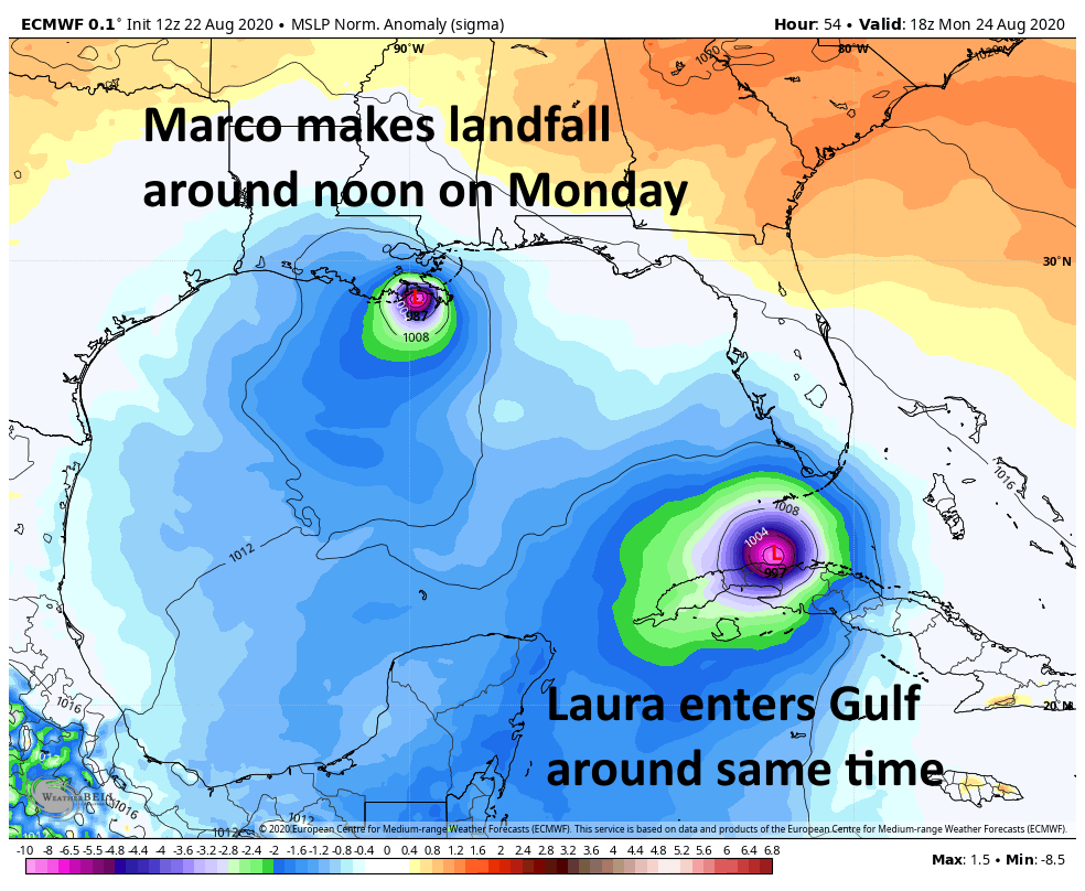
While we cannot rule out a more westward track toward Texas (and of course, we’ll continue to monitor the system), at this point it appears most likely that Marco will come ashore over Louisiana, or even Mississippi. Because we can expect the strongest winds, waves, and rains to the east of the land-falling center, this means the most likely outcome for Houston is moderate to minimal effects. The northern Gulf of Mexico coast will need to watch Marco closely over the next couple of days. Although Marco now seems likely to become at least a moderate hurricane, it should encounter enough wind shear to weaken to a tropical storm before landfall a couple of days from now.
Tropical Storm Laura
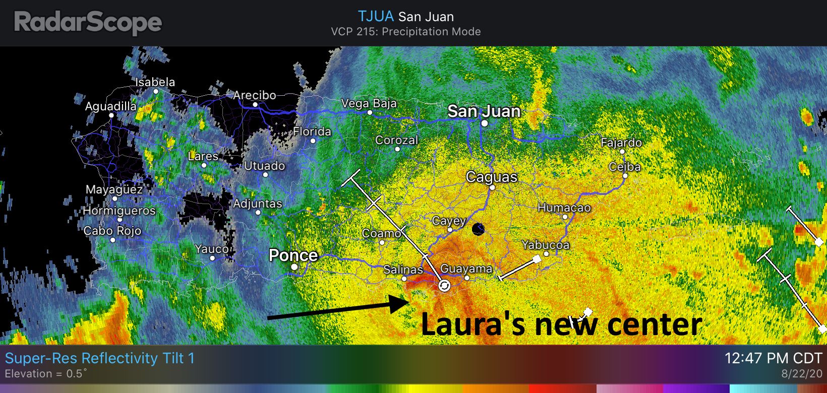
This system has strengthened some today as its center has become a little better defined. Shortly before 1pm CT, the center was located just offshore the southern coast of Puerto Rico, and it may briefly come ashore later today. In this morning’s post we outlined some of the factors surrounding Laura’s potential to intensify over the next day or two as it encounters Puerto Rico, Hispaniola, and Cuba (i.e. to shred, or not to shred). From this image you can see how predicting this is touch-and-go.
Because we don’t know precisely how much time the storm will spend over this at-times mountainous terrain, there’s not a whole lot intelligible we can say about Laura’s intensity upon entering the Gulf of Mexico on Monday. However, assuming some semblance of a circulation remains by then, conditions in the central Gulf of Mexico would allow Laura to strengthen, quite possibly into a hurricane.
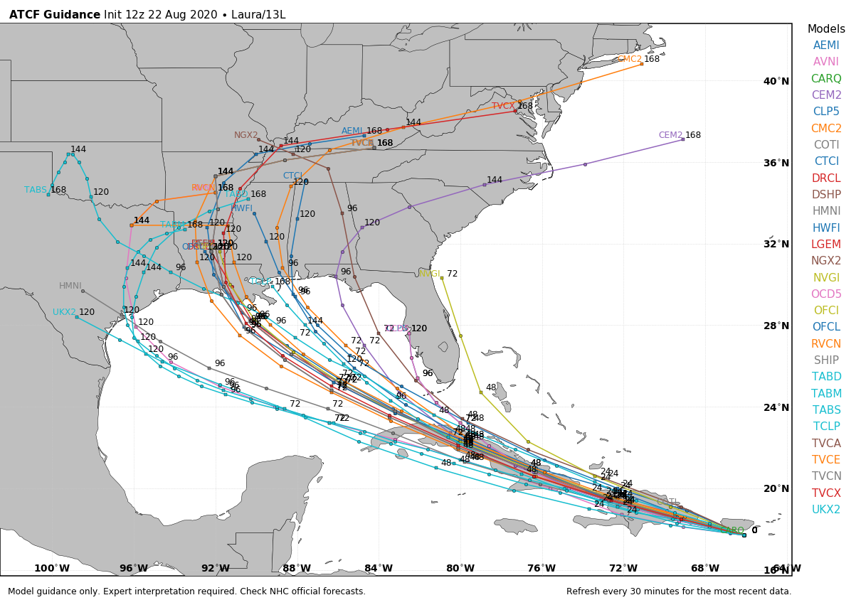
We still have lots of questions about Laura’s track after reaching the Gulf. The storm seems eventually destined for Louisiana or Texas, but it could come as far east as the Florida Panhandle. If anything, the models this afternoon are leaning ever-so-slightly toward Louisiana over Texas, but we’ve seen plenty of flip-flops so our confidence is quite low. If Laura were to come to Texas, we probably would begin to see its effects by Wednesday night or Thursday.
ON THE BRIGHTER SIDE: I think we’ll have a better handle on Laura’s track over the next 24 to 36 hours, which should still allow several days for final storm preparations—if needed. So as usual, we’re asking you to hang in there with us for a little while longer. And if we can get through Laura, it looks like the tropics may quiet down for a bit, allowing all of us to take a breath.
Matt will have our next update, no later than 9pm CT Saturday.

NHC still has Marco hitting around Freeport.
I trust Eric and Matt more.
NHC only updates forecast tracks every 6 hours. The features driving what Eric and Matt are seeing won’t be reflected in the NHC track until the 4 PM update.
NHC only updates the track at specific times. I would imagine it will reflect in the next update if they agree with the shift
I’ll go out on a limb and say even if they agree, they won’t reflect that full shift in the 4 PM update. They’ll go to TX/LA border at 4 and not all the way to eastern LA until the 10 PM.
This is probably also correct. They will be conservative, as they should be, so as not to flip-flop their forecasts. But in the case of Marco, the 12z model guidance builds on trends from earlier models, and is quite definitive.
Welp, that limb broke off underneath me. I like this pair of cones a lot better for us, but I also am really concerned about our neighbors to the east.
That is correct. I would anticipate a fairly significant shift eastward in their updated forecast at 4pm CT today.
And there it is. Thanks for your work, guys. This site is invaluable.
Yep, like clockwork!
Probably just haven’t refreshed (surprising)
Thank you. Seriously. You guys are invaluable.
God bless you, Eric and Matt.
Thank you again for your clear understandable explanations. I should wear my Space City Wearher t-shirt when I read these.
Bold call for Eric to put the landfall near New Orleans when the NHC still is forecasting Marco to go in south of Freeport, TX. We will see who does better with this the NHC or Joe Bastardi over at WeatherBell. That is a huge difference …
Man I’m really confused
Any thoughts of Rockport area ?
In the spirit of 2020, since we can’t have a hurricane next week can we have an earthquake or volcano instead?
Wouldn’t the steering currents for Laura be the same as they were for Marco?
Bet tin’ on Eric & Matt!
Heck out the spaghetti model plot. https://www.tropicaltidbits.com/storminfo/14L_tracks_latest.png
Eric, I can’t help but remember something Neil Frank pointed out to me while Ike was still in the Gulf. He noticed that Ike passed directly over the spine of Cuba. “Do you remember the last time that happened?” he asked me. “1900,” I said. The last time before that, he said, was 1886, which was the storm that destroyed Indianola, and the time before that was 1875, the first Indianola hurricane. “I’m not trying to scare anybody,” he said, but at that point everybody within ear shot in the newsroom was defecating a stone. Sure enough, Ike headed straight for Galveston. The bottom line:
Hurricanes that pass over the spine of Cuba have a history of heading for the upper Texas coast.
Dennis and Charley both crossed the spine of Cuba and didn’t impact Texas. And those are just example from this century.
Thanks so much for these in-depth updates! I tell everyone to subscribe to y’all, especially this time of year 🙂
Thank you Eric & Matt!
Like the others, just another thanks. It’s been fun (and frustrating) being 6-12 hours ahead of everybody else relying on the hyped forecasts.
Thanks for giving science and model-driven forecasts! I believe what you guys predict over most others.
BUT… Since it is 2020… Have you taken into account the effects the alien invasion (scheduled for this coming Wednesday) will have on Laura’s track?
Local media is joke…. Thanks for the accurate updates…. Have y’all ever considered an app? Would be nice to have an accurate local weather app.
I’m in Houston….where’s our rain?????
Thanks for these invaluable updates!
I have a dumb non-native Texan question…what beyond the basic kit, food, water, loose garden items, does one need to prepare for? What is the trigger for an evacuation, for example? Do we need to board up windows in areas like Katy, for example?
If you/family or your pets take medications, make sure you have enough of them. Baby wipes are good for a basic bath/freshen up if you can’t shower. But i think the rest that you said should suffice.
If you live in a place with well water (if you don’t get city water) fill up your bath tubs, sinks, and a few large pots before the storm hits. Well water is pumped out with electric pumps so when the power goes out you won’t have water to flush toilets or bathe with.
If flooding is likely, put important belongings in the attic or on top of a mattress. Park your car on high ground. A lot of people were parking their cars on the roads that are higher than their neighbourhoods during Harvey. In Galveston, people that live close to the water will park at the Home Depot, etc.
Evacuation depends on what local officials say. Galveston, Freeport, Matagorda, etc will evacuate first. We all evacuated during Hurricane Rita because it was right after Katrina and it didn’t even hit us. It turned like at the last minute! But people were stuck on I-45 for like 20 hours trying to head north. It was a nightmare.
Such a pleasure to read an article that is punctuated and coherent.