Eric and I had a conversation this spring to discuss some new ideas for the site, and ways to help readers navigate hurricane season. We absolutely feel people’s uneasiness every time it rains here, and a general sensitivity to the rumor and speculation that springs to life during hurricane season. So we have decided that every week or two, we will publish a more in-depth outlook for tropical activity in the Atlantic Ocean, Caribbean Sea, and Gulf of Mexico so that you understand what’s happening, and what could happen in the next couple weeks.
Tropical outlook in a sentence
Tropical development is unlikely over the next week or so across the Atlantic Basin, but we are eyeing July for a possible increase in activity.
Near-term summary
Historically, we would watch the Bay of Campeche and Gulf this time of year for development.
As of now, no tropical activity is expected over the next week, as conditions should remain mostly unfavorable for storms to develop in those areas and elsewhere.
Looking at satellite imagery from Tuesday morning, we have a couple tropical waves moving across the eastern Caribbean and a couple disorganized waves elsewhere.
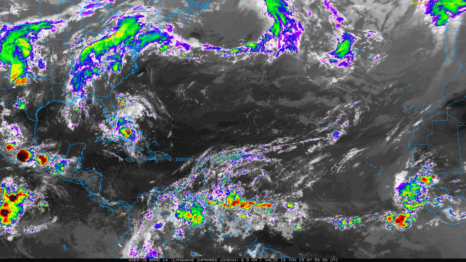
None of these waves is a candidate for development as of right now, and if anything, they should fizzle out and stay safely away. So: Good news, as we just don’t see much of anything out there.
Weather model fantasy-land
One of the biggest hurdles to good tropical information during hurricane season in the social media era is a tendency for folks to mention a model solution with zero context or just because it shows something extreme. You’ll see something like, “This model is just one solution but it shows a category 10 hurricane in the Gulf in 15 days! You probably shouldn’t believe it, but here it is anyway.”
Is there anything showing up on the models in days 10-15? Not at this time. The GFS model, which is the most frequent offender with fantasy-land storms is quiet right now. The GFS tends to have a bias early in the hurricane season, and then again later in the hurricane season. The bias is worst in May and early June, where it can often spin up systems in the Caribbean that never materialize. I tried to run the math on it last season, and during the month of May 2018, 79% of the time the GFS showed a storm beyond day 10, it never materialized.
Now, the GFS model was recently upgraded which should hopefully lead to reduced false alarms, but we won’t know much about that in practice until next May. Within the season, it still seems to show more false alarms than not, and Eric and I try to sort through the noise for you. Let this just serve as a reminder to be cautious of extreme modeled solutions posted on social media without much context.

Long-term outlook
Looking beyond the next 7 days, I do think we will see some changes. This will be a little complex, but I think it is interesting and somewhat predictive. In meteorology, there’s a recurring pattern called the Madden-Julian Oscillation (MJO). You can read more about what it is and how it came to be here. But in a nutshell, it’s looking at thunderstorms, or convection, around the globe in the tropics. Every so often, you get a recurring pattern where an area is more favorable for thunderstorm development than other areas. That’s typically an MJO wave, and it can circle the entire globe over 45 days or so. The MJO isn’t always coherent enough to utilize from a useful forecasting perspective, but every now and then it is coherent, organized, and offers enhanced ability to make longer-term predictions.
I believe that we are in such a period right now.
To explain this, let’s utilize a plot that shows essentially where the best rising air is in the tropics. This is from the GFS model. The top panel is a snapshot of last night. The middle panel is an average forecast through June 25th, and the bottom panel is an average forecast from June 26th through July 2nd. In an active MJO period, this map would be fairly lit up, and that’s what seems to be happening.
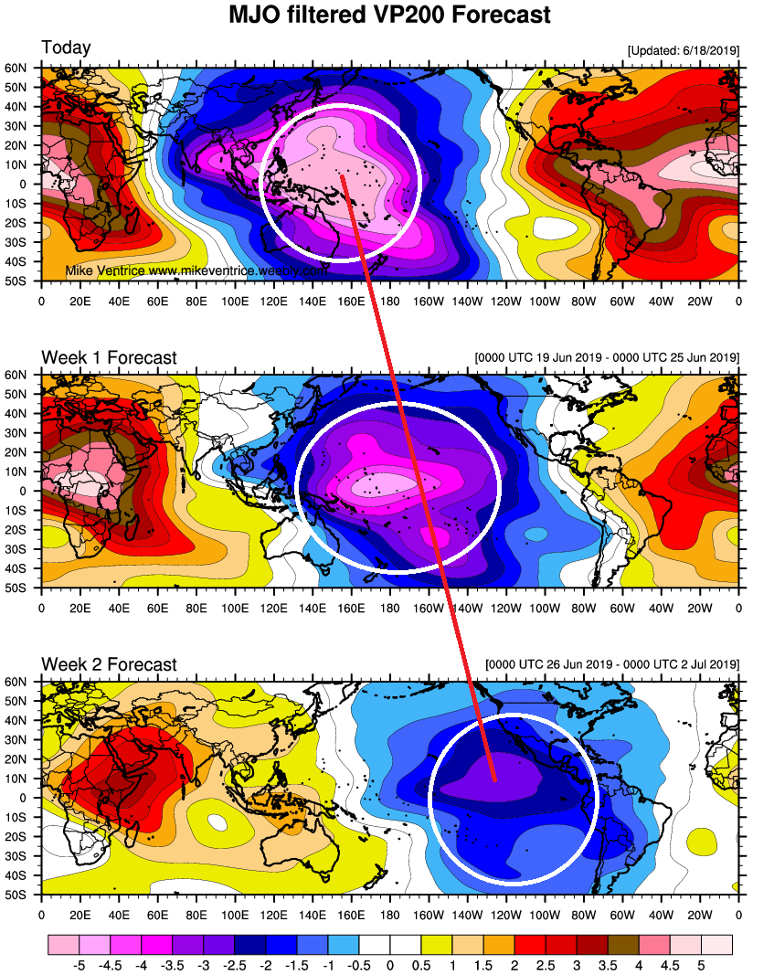
This map above represents a forecast of 200 mb velocity potential. What the heck are you talking about, Matt? In simple terms: The purple/blue color on that map above represents where the atmosphere is most favorable for widespread convection, or thunderstorms in the tropics. As that wave progresses from west to east, tropical development becomes more likely in the Atlantic.
Through early next week, that MJO pulse will move east of Australia and into the Central Pacific. Heading into later next week, that will shift east across the Pacific toward Central America.
There are other factors that can and will play into this. But, if you figure the MJO wave holds together this whole period, tropical activity should begin to become more likely in 10-14 days in the Eastern Pacific, where it has been very quiet this season. After it crosses the eastern Pacific, the MJO pulse would arrive in the Atlantic around the 4th of July or so. That may be the spark needed to get the tropics back up and running, and that’s why I believe we will see a higher chance than usual of activity somewhere in the tropics in early or mid-July. Conditions would probably shift back closer to average later in the month.
A couple very important notes here:
1.) There’s no guarantee that all conditions necessary are going to come together to allow tropical systems to develop. Not every MJO passage guarantees storm development; it just boosts the odds a bit.
2.) Even if all the conditions come together right and we get a storm or storms, there are no rules that say one of them will be in the Gulf. A lot more goes into steering these things than an MJO wave, and those are things we won’t see until a week or less in advance. For all we know, we could have two fish storms or something. The forecast concept I’m laying out here would verify, but the impacts could be nil.
3.) It’s also possible that the MJO wave falls apart before becoming a player in the Atlantic. I have seen forecasts fail here, so I would not rule it out completely. But I tend to believe it will hold together.
So, I just want folks to be aware that a lot goes into trying to forecast tropical activity, and these things are difficult. Nevertheless, we look for predictability where we can, and based on my experience and what I have learned, I think we have a period of slightly more active than usual conditions coming in early or mid-July.
This was an awesome read. Thanks much!
Thank you! This is interesting!
Thank you!
THANK YOU GUYS! Such awesome information, I can’t describe how appreciative I am each day to take just a few minutes to read your daily posts. Great Job!!
I think I understood some of this post, put it reminds us that you and Eric understand >all< of it, and that we are at the right place for accurate, useful information. Glad I sent in a (modest) donation, and hope others will as well
Thanks for the deep dive! I love learning the back-of-the-house info on weather prediction.
I follow weather due to ‘hysterics” caused by having lived thru several devastating hurricanes. Thank u for making the information easy to follow and providing the graphics and explanation. Excellent!
Excellent communication skills
Excellent communication skills
Thank you so much for caring about all of us!
I really appreciate the the dedicated post, the high level summary and the more detailed explanation. You guys are awesome!
Very informative. Thanks again.
Hope everyone has the National Hurricane Center and/or the National Weather Service forecast bookmarked on their devices. And of course Space City Weather. Check in on them every day. Preparation and information are key. Don’t let a storm or hurricane catch you with your pants down!
Love this addition.
Great idea! I really appreciate your no-nonsense, no-hype approach to things.
Fantastic read and as informative as always. Thank you!
This Florida native loves it and looks forward to more!
So, the MJO travels west to east across the Pacific, Central American, and the Atlantic. Does the large land mass of Africa disrupt or destroy an MJO wave?
Also, tropical systems travel from east to west (at least in the northern hemisphere). How does a tropical MJO traveling eastward create a tropical system that travels westward?
You are correct on all accounts. So don’t think of the MJO so much as a bunch of thunderstorms moving west to east around the globe. Think of it as almost a background signal…something that can enhance processes already in place. Storms will still move east to west in the Northern Hemisphere, but as an MJO wave works across in the background, it almost seeds new activity as it passes. So you may have had a tropical wave there with or without the MJO wave, but because it’s passing, perhaps it can offer a little extra “oomph” to that tropical wave. The atmosphere is super complex, and there are a lot of background processes that you can’t see day to day, which is why finding signals like this is so exciting…and research on it is still progressing.
As to your comment about Africa, it probably wouldn’t disrupt an MJO wave. We’ve seen these things do multiple circuits around the globe before. Eventually, something will happen globally to cause it break down, but it wouldn’t be land…not like a hurricane or something.
Thank you so much, very enlightening.
Great information, thanks for taking us into the weeds to understand a little more about the difficulty in predicting these storms, and about how they form. I always appreciate the no-nonsense, no-hype into that you share here.
Incredibly interesting ! I really appreciate your time and effort to put all these updates together, most of my street follow you guys too. Im learning a lot about weather , keep up the awesome work!!
“This model is just one solution but it shows a category 10 hurricane in the Gulf in 15 days!”
Watch out for those Cat 10’s, 400 mph winds can do some real damage to your house.
Thanks so much for all of the updates! I think that a weekly or so update on the tropics is an excellent idea!
My inner weather nerd is doing a happy dance LOL Thanks y’all for everything you do 👍🏼👏🏼👏🏼
I think your infographic of tropical trends is an excellent idea. I would much rather read the explanations and possible influences refreshing and far more informative than the “Chicken Little” approach of mass panic at the mention of the “H” word. Thank you for your dedication. I wouldn’t miss a post, particularly in terms of severe weather.
Good addition to your page. The background information given now should help as we go through this season of storms. Love your daily posts and look forward to the new segment! Keep up the good work.