I want to start my Friday post on a positive note. For weeks it feels like, Eric or myself have been writing these posts saying “we honestly don’t know when this excessive heat is going to meaningfully end.” We all know it will still be hot; it’s August after all, but it would be nice to tone it down just a little and maybe bring some rain back into the picture.
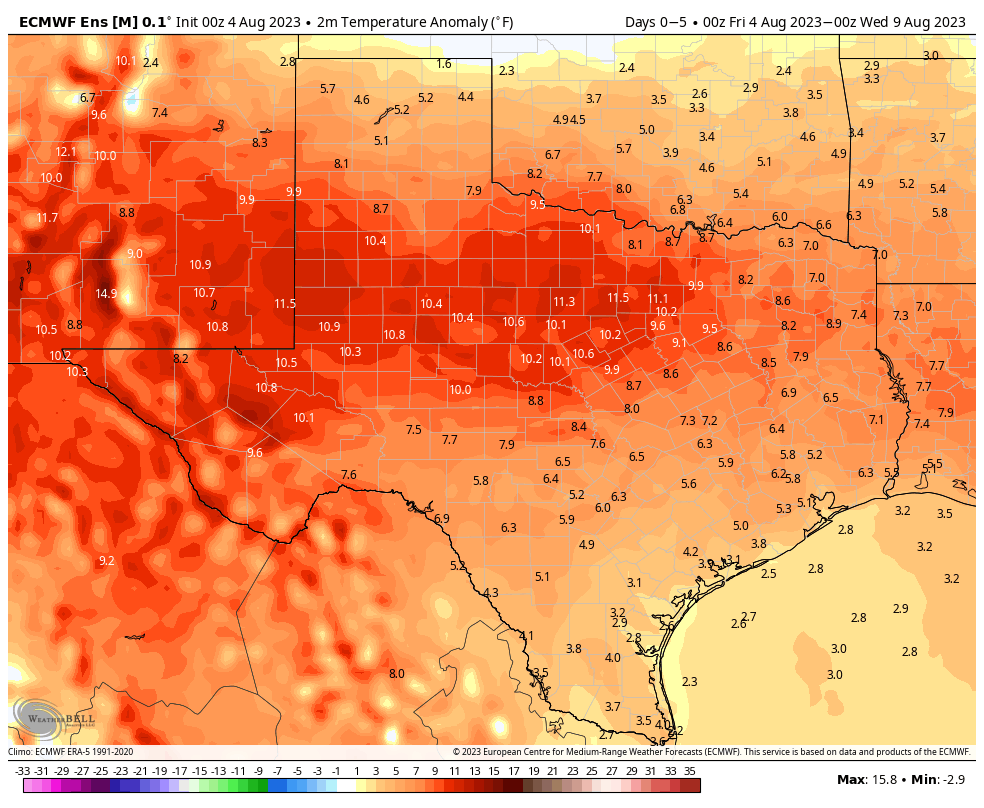
Eric has alluded to some potential change at the end of posts the last day or two, and I think we’re starting to build some legitimate momentum for this to occur. As we move beyond days 7 to 10, we begin to see a bit of a shift in the pattern showing up in modeling. High pressure in the Southwest & Texas shifts just a little more to the west. Heat is established now in the northwestern corner of the country and parts of Canada.
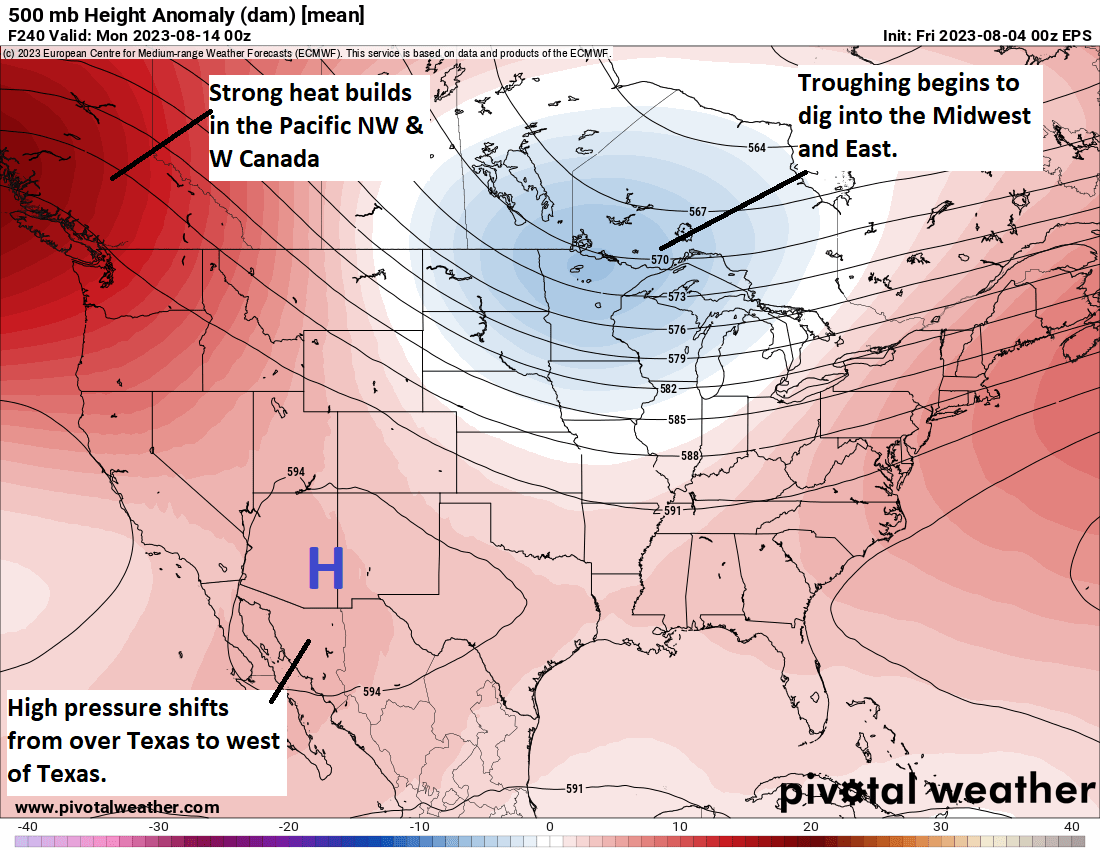
What this may do is help carve out a trough in the eastern half of the U.S. This is helpful for us in Texas because if this happens, it sort of puts us in the middle. Meaning, yes, it will still be fairly hot here, but not at record levels (think upper-90s instead of low-100s). It would also probably allow for the door to the Gulf to swing back open again and bring back at least some rain chances.
This is good news because drought continues to gradually worsen in Texas. The Climate Prediction Center hazards map for August 11-17 shows that many areas in Texas are at risk for “rapid onset drought.”
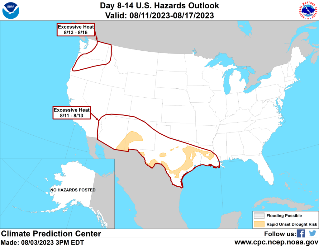
What exactly are they talking about? Essentially “flash drought,” which is what happened in the Central Plains in 2012. Drought quickly goes from kind of bad to very bad very fast. This can have implications on agriculture, water supply, lake levels, etc. We really don’t want to be dealing with a flash drought here, but given the recent issues with wildfire flare-ups, as Eric noted yesterday, we may already be descending that path.
This is why we are really, really hoping that what we see beyond day 10 can hold. Fingers crossed.
Today and the weekend
Meanwhile, yes, it’s more of the same. More heat. More advisories or excessive heat warnings. More humidity. Drink more water and try to limit outdoor exposure when possible. Please also check on your neighbors. There have been a couple instances of showers popping up in recent days in central part of the Houston area. That could happen again today or tomorrow, but consider yourself extremely lucky if it does.
Summer to date, we’ve just tied 2009 for the 3rd hottest on record in Houston. We are only a couple tenths of a degree behind 2011 for 2nd hottest, and over the next 7 to 10 days, we’re likely to go neck and neck with that summer. I suspect 2011 will pull away in the end, assuming our pattern does change some later in the month.
Next week
Copy and paste. More heat and more sun. Look for a slight rain chance Tuesday afternoon and then maybe again by Friday. Any changes that take place in the weather pattern would not materialize before next weekend. So buckle in.


I look forward to your posts every morning. I’ll take any rain chance I can get. Thanks for all you do!
Thank you, Matt. I remember the drought of 2011 and hope we don’t come to that.
Which summer was the hottest?
2011 is king, followed by last summer, and 2009. If I had to guess it will be 2011, 2023, 2022, 2009 after this year.
is this heat dome suppressing hurricane activity?
Suppressing, no, but shielding us, yes. Not that there have been any storms to threaten land in recent weeks. But if something were to form, say, tomorrow (it won’t), we’d be shielded from it in Texas because of the “heat dome,” or high pressure.
I dont know how people can stay indoors all the time in Houston. I work on my yard at least every two days, I go running to the park at night, I take the bus so I walk to the stops and sometimes have to wait, and I take my dog out for walks a couple times a day. I have never in my entire life sweat so much in a summer. It has been miserable. The weather is def changing.
I don’t know how people can go outside all the time in Houston. Staying indoors is pretty dang easy. ¯\_(ツ)_/¯
We run in the evenings as well, but it feels completely unbearable during the day. I can normally stand it for about 20 minutes but even that is a stretch lately. I can’t wait for some rain chances. I love to be outdoors, so this has been difficult for me.
I’ve just finished cycling 3 hours on the Hershey and reservoir trails, riding this summer is definitely getting to be quite a chore. 😉
Wow. Toughest part of the day. At least you can make your own “cool” breeze
O go outside everyday, ride a bicycle or motorcycle to work, walk, walk my dogs, mow the lawn, etc. I get soaked in sweat, but that is normal. Maybe your body is just changing.
If the pressure map beyond day 10 in this post occurs, would it mean tropical steering that favors the middle of the Gulf?
Not an expert, but I would say yes. At least there is a chance that would happen. These heat wave bummer summers, followed by something even worse!
Yes, in theory. I would assume things still stay to our east, but it definitely would crack the door open a bit more.
While relief from extreme heat and drought conditions is absolutely welcomed, it does also increase the possibility of “opening the door” to tropical activity, just when hurricane probability really begins to ramp up. My concern is that with the trough digging in to the north and the high moving away (or diminishing) some, we may go from drought to Harvey. Who knows.
My understanding is that excessively dry land has a harder time soaking up heavy rainfalls as well. If we were to go from drought to Harvey, it could end up being quite a bit worse just due to that feature of dry land.
The same can basically happen with a stalled front and Pacific upper trough nearby with a persistent deep Gulf moisture fetch. Which has sometime happened in September before. Especially in El Niño.
At some point the rotation of the earth and angle of the sun will end this, right? Please?
Absolutely yes. The Earth’s 23.4 degree tilt is what will finally cool us off in a few of months. The northern hemisphere faces away from the sun during the winter months which has a natural cooling affect across the entire northern hemisphere. It won’t be to long and we will finally be opening our windows when those cool dry Canadian airmasses start blowing through.
I can’t wait!! Right now it seems like it’s never going to be cold again. The only thing keeping me going is the Sun sets 1 min earlier every day now.
High backing off to the west.Ridge in the east. Gee when did this happen last. ? Harvey?
The ridge backed off to the west last August and we got alot of much needed rain, but no hurricanes. The high pressure ridge backing off to the West or East doesn’t mean we will automatically get slammed by a hurricane luckily. However we are a little more vulnerable for hurricanes whenever the upper level high shifts away briefly.
I was looking. at the 6z.gfs. forecast. It showed a low in the western gulf in 10 days. It has since backed off. But it does open the door somewhat.m
It’s quite unlikely a hurricane will hit the TX coast with the strengthening EN and it’s historically proven effects on the dominant high, for the rest of this season. At the most, a TS, maybe. But even that might be too generous.
Houston has bearable weather Nov through Feb. The other 8 months are horrible. So, only about 90 more days to go until we can step outside.
Hey, just completed the mid day run….97F with simple wet bulb 78F. It’s a fine Houston day in August. If you keep being told it’s gonna be extreme heat you begin to believe it. Nonsense. Admittedly going from AC at 72F 40% RH buildings to outside back to buildings is tough. But if you work up a sweat, that wonderfully low wet bulb kicks in. 5PM is AC time.
Forget wet bulb, there’s a dim bulb problem with you
Funny!
That’s politic. The data suggests it’s going to get warmer. I adapt. I like it here and don’t want to move north. But we’ll see.
I don’t know if any data can predict the future. I think that summer of 1988 was the hottest ever.
You are a worm. Clearly.
Several mentions of Harvey catch my attention, question to SCW: was Harvey’s stalling due to a very unlucky blocking pattern, or just garden variety ridges?
Can y’all help me understand why 5pm feels so much hotter than 1pm this summer? Is it always like that? Why? I thought 12-3 was the “hottest part of the day.” Has that changed?
Often times the dew point rises during the late afternoon and early evening hours. This can make it feel hotter even though the ambient air temperature has actually decreased some.
This is a great question. If you watch the temperature during the day the high point hasn’t been until 4PM or so. It’s actually fairly pleasant out before 11AM. And the sun is at zenith around 1PM. I think it is the effect of the pressure ridge aloft containing the warming air mass below, like a kettle of water, heat builds up until finally the sun backs into the west.
Can’t we simply kill every human, so the so-called “man-made” climate change would be eliminated? Oh, wait, that’s not quite how it works…
It seems like everyone here has forgotten that we’re in a keyword, ‘Strengthening El Niño‘ summer, that will likely continue to into the fall. Which has climatologically proven to deflect hurricanes from the TX coast due to the larger influence of the upper-level flow and persistently closer jet stream east of the heat dome High. MUCH less, a Harvey (which happened during a returning La Niña year to top it off).
I guess the usual day in/out Texas summer heat/humidity makes older people auto-expect a hurricane when a very large and persistently dominant heat dome high, just starts to lose some of its grip around here this time of year to allow rain potential to *slowly creep back. Even in an EN summer…