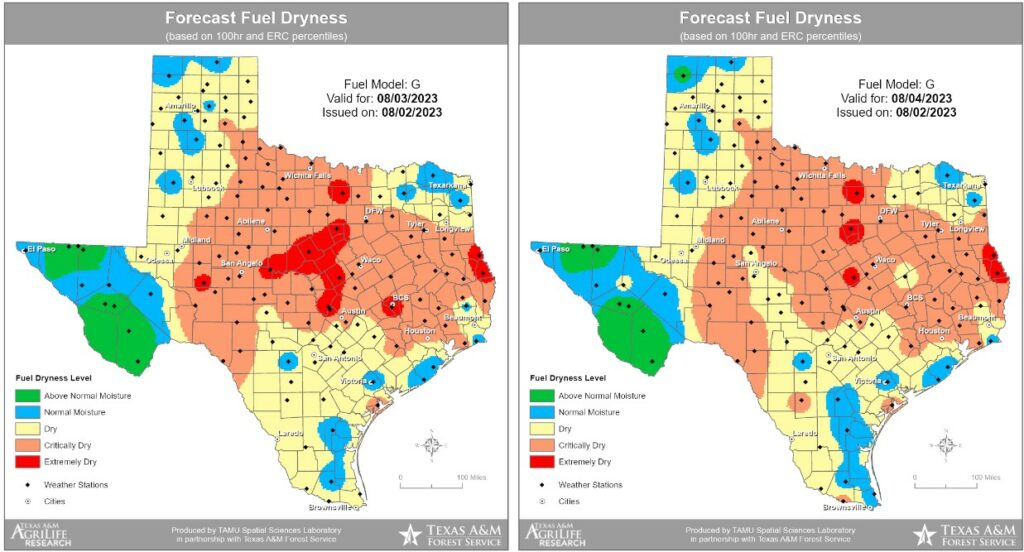
Good morning. One byproduct of the heat and lack of rain this summer has been increasingly dry grasslands, and accordingly we’ve started to see the outbreak of wildfires. For example, on Wednesday, the Texas A&M Forest Service worked hard to contain the 215-acre “Snowhill Fire” in San Jacinto county, to the north of the Houston area. Fire conditions will persist for at least the next several days with the ongoing heat and could be exacerbated by winds a little bit higher than the region has has seen of late.
The model output below from the Forest Service highlights areas where fuel on the ground, particularly grasses, is susceptible to burning.
Thursday
As for the weather forecast, well, do you need to ask? High pressure continues to dominate our weather and we will see highs of around 100 degrees today with perhaps a 10 percent chance of rain. Skies will be mostly sunny, with lows near 80 degrees. Winds will be light, generally from the southeast, at 5 to 10 mph. Basically, this is unchanged from what we’ve been experiencing.
Friday
More of the same.
Saturday and Sunday
As high pressure starts to slowly slide westward, temperatures may come down slightly this weekend. We’re talking highs in the upper 90s to 100 degrees for most of the area, instead of highs around 100 degrees. So, probably not noticeable. Rain chances both days are on the order of 10 percent with mostly sunny skies.
Next week
The forecast for next week still calls for hot weather. But there’s still the potential for some slightly better rain chances by Wednesday or so as high pressure weakens a bit. The question is whether it will weaken enough, and I don’t think we can say that yet. Looking further into my crystal ball, I think there may be some hope for this overall pattern to change slightly, and for the better, by mid-August or so. But again, we’ll need at least a few more days before that’s something to feel confident in.


New app looks great. Still an issue with sunrise/sunset times but I’m sure that will get fixed.
I’ve really started noticing the yellowing and browning of the lawn grass around Houston these past few days. It’s toasty out here.
“Hope is a good thing, maybe even the best of things.” Andy Dufresne from The Shawshank Redemption
In todays semi-daily dose of hope from Glenn we go back in time. Back before the Pacific Climate Shift of 1976-77. In August of 76′ the lows every night of the month dropped to 75 or degrees or lower and four times we dropped into the upper 60’s. If the Pacific changed from a cooler phase to a warmer one in 1976-77 it stands to reason that it can change back again…
https://www.weather.gov/wrh/Climate?wfo=hgx
Hey guys..as we approach solar max conditions plus the el nino, might that combo have something to do with our extreme heat? Don’t know of any correlations, but that’s why you make the big bucks.
Doesn’t relative humidity need to drop below 30% for wildfires threats to truly be high?
Houston heat toasting lawns to golden perfection…
The 500mb “ridge of high pressure” is supposedly an atmospheric feature, yet you never see it show up in, say the Northeast. At least, not persistently as in the Texas region (the Southwest/Rockies and South Central/MS River valley areas get affected alot too).
There’s probably some unknown/underemphasized mechanism for it because it’s not the classic Hadley Cell (as there are longitudinal discrepancies).
Is ‘Houmidity’ in the app a typo or a pun?
🤗
You know, with the Gulf quiet, this would be a good time for the SCW team to sneak in a 10 day vacation. Just set up some sort of auto-post about it being hot and humid with no relief in sight. Nobody would notice.