In brief: The overall forecast looks more ominous, with atmospheric conditions favoring another round of strong showers and thunderstorms later today and tonight in the Houston region. We are instituting a Stage 1 flood alert for the entire area, and may possibly upgrade that to Stage 2 for areas north of the city later today.
Wednesday
Conditions this morning will be fairly calm, with only a smattering of light showers across the region. Highs today will reach the mid-80s, with mostly cloudy skies. Winds from the southeast will be a little higher, at about 10 mph, with gusts to 20 mph.
However, our confidence is increasing in another bout of fairly strong showers and thunderstorms later today or tonight. These storms will likely fire up late this morning, or during the early afternoon to the west of Houston and then move through this evening or during the overnight hours. I want to stress there is a fair amount of uncertainty in the timing and location of these storms, which will bring the potential of damaging winds and heavy rain. Given this uncertainty, we will likely post an update this afternoon to the website.
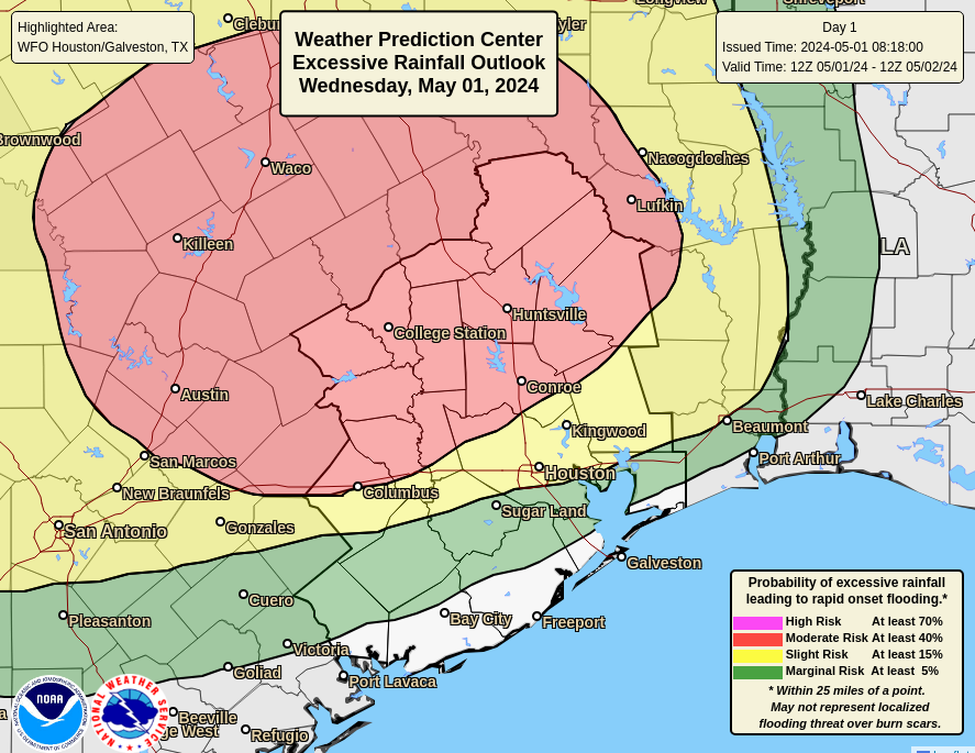
At this time the greatest threat of heavy rainfall lies to the north of Interstate 10. However, some of the latest modeling and data point to a more widespread event that could bring heavy rainfall across the Houston metro area down to the coast. Regardless, I’m concerned about the potential for additional flooding along the East Fork of the San Jacinto River, which has already reached a major flood stage due to heavy rainfall earlier this week north of Houston.
In terms of rainfall accumulations, our model guidance is not at all consistent. Much of the area is likely to see an additional 1 to 3 inches of rainfall, but given the increasingly favorable setup for heavy rain I could see some locations picking up as much as 5 inches or more of rainfall tonight into Thursday morning. For now we are issuing a Stage 1 flood alert, which means nuisance street flooding mostly, for the entire Houston area. We may modify this later today.
Thursday
Rain chances will start to diminish during the morning hours on Thursday, but we’re likely to see some additional scattered showers throughout the day. Skies will again be mostly cloudy, with highs in the mid-80s. Lows Thursday night will be in the 70s—so fairly muggy and warm.
Friday
This will be another mostly cloudy day, with highs in the mid-80s and a chance of scattered showers and possibly a few thunderstorms. Rain chances should end at some point on Friday.
Saturday and Sunday
The weekend looks partly sunny and a bit warmer, with highs in the mid- to upper-80s depending on the extent of sunshine. Winds will be from the south-southeast, gusting up to 20 or 25 mph so there should be a breeze all weekend. With low to non-existent rain chances, the region will get a chance to dry out.
Next week
No changes in the forecast for next week as high pressure settles in. We can expect warmer weather, with highs likely reaching 90 degrees by Tuesday or Wednesday. The rest of the week looks warm and muggy with low rain chances. I’m hopeful that a weak front may arrive in time to cool us down slightly by next weekend, but that is something I certainly would not bet on.

I have a question for your next Q&A… can you define “north of I-10” and other directional terms you use? How far north is north of I-10? How far out is the “Metro area”? (I live and work in the Cypress area)
Literally north of I 10…so anything above the interstate. The Houston metro area is Harris County and it’s contiguous counties and Austin County. If you Google Houston Metro Area it will give you a map.
I-10 is monstrously wide enough in places that the north lanes and south lanes probably deserve their own special weather reports.
The Houston CAP will break this up
Every day is the same forecast: hot, wet, and disgusting. I don’t know why anyone lives here by choice. I am ONLY here for work and I’m so miserable they finally gave me the transfer back north I’ve been begging for. I’m counting down the days.
Glad you received the transfer! 😄
I’m glad you’re leaving as well!
And hopefully the rest of the soft transplants get out too.
You are a very negative person and we’re glad you’re leaving.
I grew up in the Great Plains and had your situation in reverse. Winter was awful, summer was wonderful. If anyone is unhappy where they are and have an opportunity to make a change for the better, why wouldn’t they?
nobody comes to Houston for the weather or scenic flat geography…but I’ve never had trouble finding work, and I own my own home, which is more than can be said for a lot of other cities. i actually agree, but i’m not about to go whine about it on a weather blog.
Then why bring up owning your home, has nothing to do with weather?
Because whiners and hometown-haters are annoying.
Well… bye!
That’s how I feel about Chicago. Why would anyone choose to live where it snows 9 months out of the year? So glad to be back in the semi-tropics here in southeast Texas. Ahh…
Well, that escalated quickly.
A number of models, including some CAMs, still aren’t picking up on meaningful precip in Houston. Tough to forecast this time of year.
Thank y’all for your helpful information with all the drama. I appreciate it.
Wow, quite a change in forecast for today even compared to yesterday’s post where we were just expecting “garden variety showers” of less than one inch!
well, if la nina is coming back this summer as predicted, then we might need all the rain we can get before then.
What may be the “dog excitable” prediction for overnight?
I’m not sure why we went from garden-variety rain showers to a higher chance of rain, and flooding, just since yesterday. I thought mid-range forecasting was fairly well honed.
And what area does SCW consider as its forecast area? It helps to interpret the forecast post by knowing just how far away from the urban core of Houston Eric and Matt are considering.
I really like the weather in Houston during the winter!
What changed atmospherically between yesterday’s “We are not looking at anything too crazy, with accumulations of 1 inch or less likely for most of the region.” and today’s “Much of the area is likely to see an additional 1 to 3 inches of rainfall, but given the increasingly favorable setup for heavy rain I could see some locations picking up as much as 5 inches or more of rainfall tonight into Thursday morning.”? I checked today’s post late and the uptick was a surprise.