Welcome to the “just in the nick of time” April edition of the SCW Q&A. Each month Eric and Matt tackle the most interesting questions you’ve thrown at them. You can leave more questions in the comments here, or hit the Feedback link in the blog’s sidebar. We’ll also scan our social media channels (Facebook, Instagram, Threads, X/Twitter, Mastodon, Bluesky) for queries. And we’ll try to get the Q&A posted sooner in May!
– Dwight
Q. Could this be is our last front until Sept/Oct? April is coming to a close soon, and I can’t recall many pronounced cooldowns in May.
A. Let’s get the bad news out of the way first. We are very near the end of the road when it comes to cool fronts in Houston. However, it is not unheard of to see cooler nights in May. That is not to say cold. If I squint into the distance, I can see a decent chance of a front around the May 11-13 period, so a little less than two weeks from now. That’s a long way out to have some confidence, but I’m modestly hopeful we may have one final fling with drier air before sultry summer settles upon us for months on end.
–Eric
Q. I had read before the event yesterday that clouds sometimes clear during an eclipse due to the cooldown. Is that what happened yesterday in Houston when we had a thinning of clouds enough to see the crescent?
A. This is a great question. The answer is yes. During the eclipse in Houston, we had an issue with various sorts of clouds. We had higher level cirrus clouds, mid-level clouds, and low-level clouds. Most of the low-level clouds were cumulus clouds. What usually causes cumulus clouds to form? Heating. You heat the ground during the daytime, the heated air parcels rise, cool, condense, and you get clouds. Well, as you begin to block out the sun during an eclipse, you begin to reduce that heating mechanism. And in time, a lot of those cumulus clouds (or what we often call “fair weather clouds”) will dissipate. The animation below is from the 2017 eclipse, and you can see how the cumulus cloud field over Missouri and Illinois really dissipated as the eclipse unfolded.
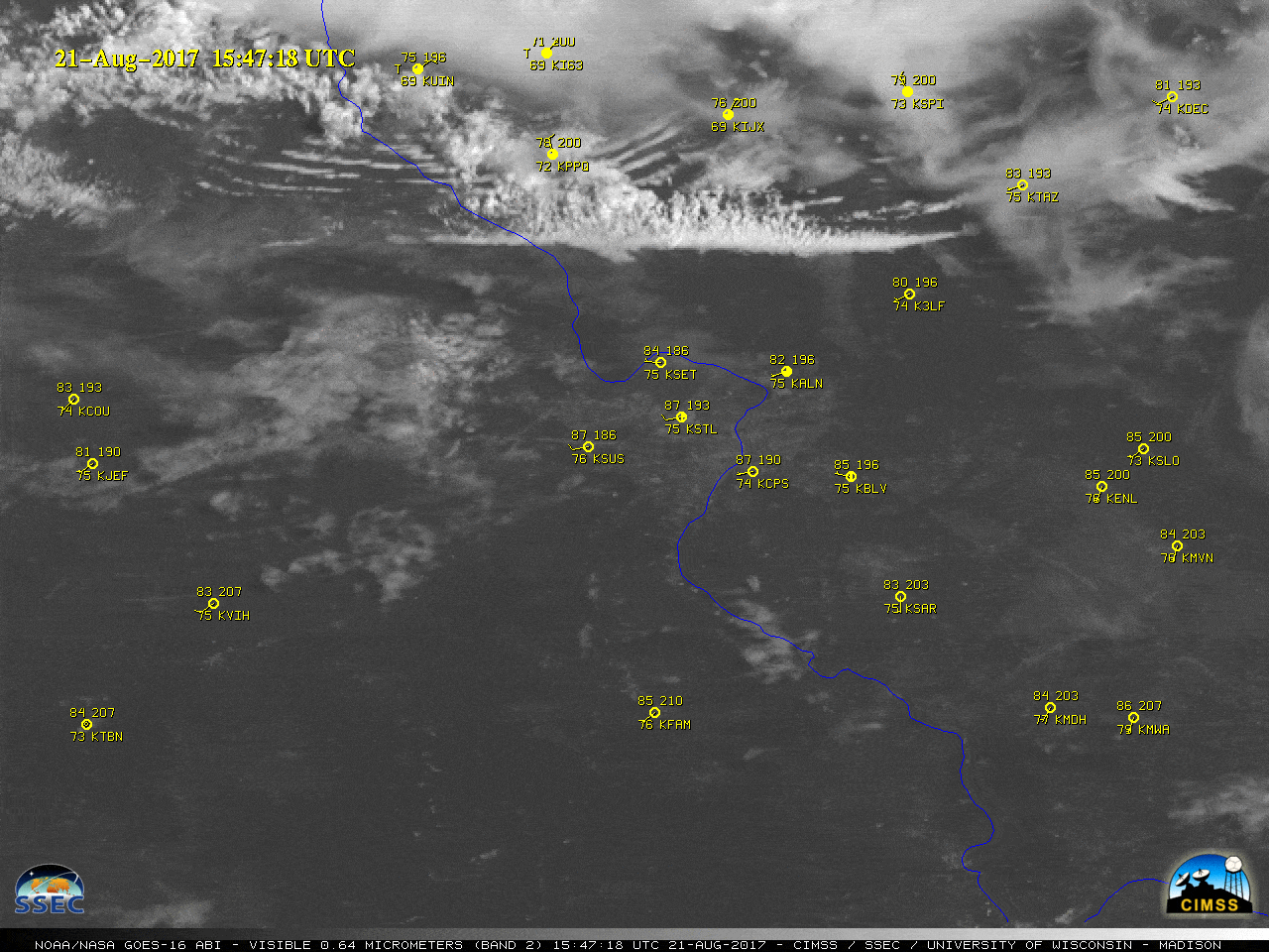
This is likely what “saved” much of Texas this year. There were still plenty of clouds higher up, which are less impacted by daytime heating and more driven by physical storm systems. But by virtually eliminating a layer of lower cumulus clouds, you had one less obstruction to view the sun, which periodically broke through the higher clouds.
–Matt
Q. How far inland would you recommend having hurricane shutters to board up if a storm comes inland? I find myself trying to calculate what would be the strongest type of hurricane that we could feel in order to decide if I want to invest in shutters, but can’t find any info. Would you guys know?
A. We’re not storm damage experts, but whether you should have hurricane shutters depends upon several factors. First of all, the most important factor is whether you’re close to the coast, as winds do die down significantly as a storm moves inland and encounters friction with trees, homes, high rises, and other structures.. The second factor is the proximity of stuff, like trees and unattended deck chairs and you name it. The most common reason windows break is due to flying debris. So if there’s lots of things around that you can imagine flying into your windows, that’s a risk factor.
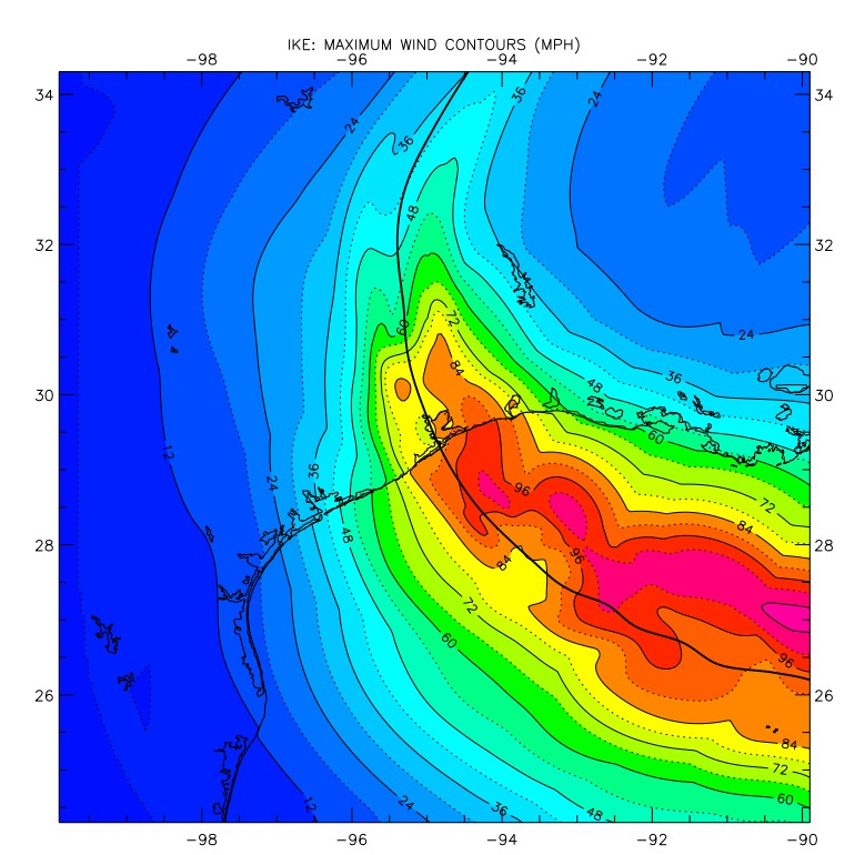
I’ll be honest with you. I’ve lived through flood storms in Houston. I’ve lived through surge storms. But I’ve not really experienced a wind storm. Hurricane Ike was the closest thing, but it barely brought Category 1 winds to parts of Houston. This was bad enough, knocking power out to the city for up to two weeks. At the time I lived in Clear Lake and we had to get a new roof. I guess what I’m saying is that it’s not just your windows, it’s also your roof. And a prolonged period without power.
I guess what I would advise is that, if you live south of Interstate 10, and can afford it, hurricane shutters are not a bad idea. You will probably never need them, but if it proves peace of mind, that is not a bad investment in an uncertain world. Make sure they’re easy to put up on short notice.
–Eric
Q. On your weather app I notice that the humidity (sorry I mean HOUmidity) can be low in the evening and then go way up in the morning, coming back down again as the day goes on. Why?
A. Relative humidity (RH) is just that, relative. Dewpoint temperature is the temperature to which you’d need to cool the air to saturate it. In other words, the higher the dewpoint, the damper the air is. Dewpoint can fluctuate, but it’s usually more stable than temperature. So, let’s say you have a dewpoint of 72°. The morning low is 75° in this example. That means your morning relative humidity at 75/72 would be 90 percent. Obviously, you warm up during the day, so with a high of 88 degrees but a steady dewpoint still sitting at 72, your RH at 88/72 has dropped to 59 percent. As the air cools around sunset bringing the temperature relatively closer to the dewpoint, the humidity rises again. It limits the usefulness of RH. This is why we flout other metrics like dewpoint to drive home how humid it actually feels.
–Matt
Q. After your earlier answer, I’m confused by the description of what “percent chance of rain” represents. I was taught in my meteorology classes that probability of precipitation in weather forecasts means the probabilistic chance that it will rain at the point specified in a given time period. For example, if I enter my zip code to get a National Weather Service forecast for my area today, a 40 percent chance of rain means each point within my zip code has a 40 percent chance of seeing rain, not that 40 percent of the land area within my zip has a chance of seeing rain. Insights? Or is this just splitting hairs?
A. It’s more or less splitting hairs. But this is a fun topic so why don’t we dive a little deeper. Let’s go directly to the National Weather Service, where we find this delightful introduction to its “probability of precipitation” explainer:
The probability of precipitation forecast is one of the most least understood elements of the
weather forecast.
I just love the “most least” phrasing. A perfectly confusing introduction to a confusing topic. Anyway, fundamentally you are correct that it is a point forecast rather than an areal forecast. But it is a point forecast based on an areal forecast. If that makes sense. Which it probably doesn’t. And that’s ok.
There are two factors that go into making a “probability of precipitation” forecast. First there is the forecaster’s certainty that precipitation will form or move into the area, and this is multiplied by the areal coverage of the precipitation that is expected. Here are two examples for how one might derive a 40 percent chance of rain:
(1) If the forecaster was 80 percent certain that rain would develop but only expected to cover 50% of the forecast area, then the forecast would read “a 40 percent chance of rain” for any given location.
(2) If the forecaster expected a widespread area of precipitation with 100 percent coverage to approach, but he/she was only 40 percent certain that it would reach the forecast area, this would, as well, result in a “40 percent chance of rain” at any given location in the forecast area.
Does that clear things up? Probably not.
But given the general inaccuracy of precipitation forecasts, I think it’s fine to think of a “40 percent chance of rain” as either a point forecast or, more generally, that about 40 percent of an area will receive rainfall during a given period of time. This is not an exact science, it’s just a forecaster making a most best guess of things.
– Eric
The most best explanations yet 😉
I take % chance of rain and divide by 2.
Last front: my old bones tell me there is a chance every 5-8 years of a good cool front at the beginning of May.
When that happens, I go to the homes tour in Galveston. Otherwise, stay home. 😉
I had “Stormbreaker” (laminated) windows installed after Rita, just in time for Ike. They’re quite expensive, but won’t blow thru until 140 MPH. I have also added storm doors to the front and rear entrances, and have a roll-down on the slider on the patio (great for security on out-of-town trips). Also added a 135 MPH rated garage door when the old one had to be replaced (which if I lived a few miles away in Webster would have been required by their city code. Yeah, expensive. But when Ike came by, all I had to board up was the service door to the garage. Nice on a 2-story house.
Good Tuesday morning. What is your prediction of a hurricane heating the Texas coast during the hurricane season. Also, what is your prediction of hurricane hitting somewhere around the Galveston area?
Ah, here we go again.
I would say a 200% probability for both.
I thought that when observed conditions were equal to historic like conditions, what happened. 40 percent of the time it rained. A statisical comparison.
In my opinion, the NWS definition of probability is the best most least useful statistic they provide. When terminology can have two very different meanings it does very little to help one prepare for what might actually happen.
Very true. I like Eric’s take more better.
Is Houston sinking and doomed in the future
Yes, if there is any justice in the world! It should have been left as a swamp.
So along the same line as the hurricane shutters, I would like to ask if there is something I should buy for flood prevention. There are so many options. Any advice you can give would help.
Is there any particular sort of boat catching your interest?
I grew up in Galveston. My home had permanent, exterior hurricane “blinds” that we closed and opened by simply turning interior knobs. When the blinds were open, we had great views; when they were closed, we were fully protected. I put the same blinds on my house in Houston 40+ years ago, and they are well worth the initial expense. They have never needed repair, service, or replacement. So I never have an emergency concerning windows. By the way, the slats of the blinds run horizontally, the same as normal interior blinds. They were custom made for the size and shape of each window. I do not know whether such blinds are still available.
One particular damaging storm that came to my mine was Hurricane Alicia.
In August, 1983, Alicia was the costliest Atlantic hurricane at the time.
Alicia was a small fast moving catagory 3 hurricane that decimated Houston’s downtown skyscrapers & area apartments.The $3-Billion damage is mostly remembered for the high winds that carryed loose gravel (used for roofs at the time) which shattered windows in many homes & apartment buildings, & the windows that blew-out in high rise office buildings in downtown.
That event led to a city building code revision that outlawed gravel being used as roofing material.
68 degrees this morning-not bad!
Regarding hurricanes, we had twisting winds and heavy tree damage during Ike, but the windows were fine. We are on the west side of Houston about 60?? miles from the coast.
WHY CAN’T YOU EVER SAY-YOUR HUMAN-GOD’S NOT, WE BLEW IT!