Good morning. We hope everyone has a safe and enjoyable New Year’s Eve today and tonight. There have been a lot of questions about how cold it’s going to get, whether it’s going to snow or ice and what to expect over the next few days. So, we’ll set out to answer those questions for you this morning!
Right off the top, we do expect hard freeze type conditions in most of the area at multiple points over the next several days. If you need tips or advice on how to prepare for cold weather, here’s some info from the city of Houston. I grew up in the Northeast, where we’d laugh about getting worked up about low temperatures in the low or mid-20s. Turns out, cold of that level can indeed be quite damaging here. If you’re new to the area, I can tell you from experience, it’s smart to go through the checklist and do what you can.
Today
It’s a gray, drizzly morning, and that probably won’t change a ton as the day goes on. We may see a bit less drizzle later this afternoon or evening. Temperatures today aren’t going to be any warmer than they are right now. We’ll stay steady in the mid or upper-40s, slowly dropping back toward evening. Upper-30s arrive in the Brazos Valley by late afternoon. Winds will gradually increase through the day today too. Expect gusts of 20-25 mph today.
But bottom line here: No travel issues are expected during the day in Houston. If you’re headed north, there are icy spots reported west of I-35 and north of I-20, mainly in the Panhandle and up toward the Red River. If you are traveling out of Houston today, I’d strongly suggest you check DriveTexas.org for the latest.
Tonight
Winds will continue to howl and temperatures will continue to drop. By Midnight, temperatures in the city of Houston will likely be down to about 34-36° north of I-10 and 36-38° south. Up toward College Station, it’ll be at or below freezing by Midnight in all likelihood. Same goes for areas around Conroe or Huntsville. Some wet roads may have patchy black ice on them, so if you will be out returning from holiday festivities or commuting late, use extra caution along and north of Hwy-105. In and around the city of Houston, we do not expect any travel issues even after midnight.
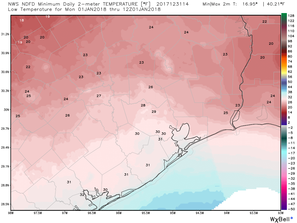
Overnight, it gets colder. Expect low temperatures on Monday morning around 30° in the city of Houston proper and near freezing in Galveston. North of Houston, it gets more into hard freeze territory, and indeed Hard Freeze Warnings are posted for Liberty, Montgomery, Walker, Grimes, and San Jacinto Counties tonight. We should see lows in the upper-20s in The Woodlands and mid-20s in Conroe. Further north, we could do low-20s in spots in the Brazos Valley or up toward Huntsville. Same goes for East Texas north of Beaumont.
In addition, we’ll still have some wind, so expect wind chills down to around 15° in Houston and colder in spots north of Houston. Take extra steps to secure any coverings for sensitive plants as well to ensure you can lock in as much ground warmth as possible. If you’re heading out tomorrow morning, bundle up.
(Space City Weather is brought to you this month by the Law Office of Murray Newman)
Monday into Tuesday morning
Monday will be a cold one. Temperatures are going to limp into the mid-30s. If you’re lucky, you’ll see upper-30s Monday afternoon. We’ll have a mix of clouds and some sun. No wintry precipitation should occur Monday. A weak disturbance Monday night may increase clouds and moisture well south of Houston (toward maybe Freeport, Matagorda, or Palacios). If that happens, a little freezing drizzle or sleet would be possible Monday night into Tuesday morning in those areas. We think this will avoid Houston. If something changes, we’ll let you know.
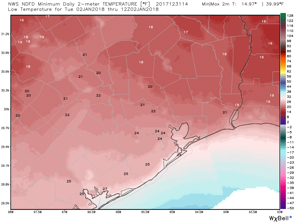
Monday night into Tuesday morning looks really, really cold. Expect a hard freeze over much of, if not most of the area. But exactly how cold we get will depend on how much cloud cover we see. If we end up partly cloudy or mostly clear, the temperature forecast above will verify without much trouble. If we see more clouds than expected, you can probably add 2-4° to temperatures, especially in Houston and south of I-10. But I would plan based on these colder forecast values. Expect mid-20s south of Houston to the bays. Mid to upper-20s will be the rule on the beaches. In the city of Houston itself, we should be able to get into the low-20s north and low to mid-20s south. For The Woodlands, Spring, and Tomball, expect low-20s to around 20° by Tuesday morning. North of there, toward Conroe and Huntsville, expect upper teens for lows.
Beyond Tuesday morning
Tuesday will be another cold day, with temperatures struggling to reach the mid or upper-30s. Tuesday night into Wednesday morning will be very much in hard freeze territory again. We could end up colder than Tuesday morning depending on how cloud cover pans out tomorrow night. Skies Tuesday night into Wednesday should clear out, allowing for temperatures to plunge, or what we call “ideal radiational cooling.” The only ingredient we lack is a fresh snowpack. Guess we can’t be greedy.
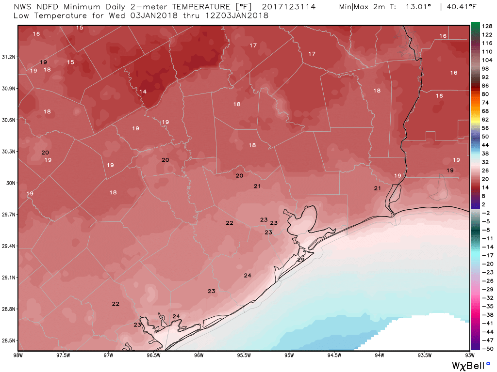
Expect teens from The Woodlands north, low-20s in Houston, and low to mid-20s south of Houston.
Beyond Wednesday, we could have one more hard freeze Thursday morning (especially north of Houston) before temperatures finally start to warm up. 60° is going to feel downright balmy by Saturday.
Eric and I will update you tomorrow if needed, but we don’t expect a ton of changes right now. Assuming that’s the case, look for our normal morning updates to resume on Tuesday. Have a safe and happy New Year!
Thanks for your good site and content
Deus Vult
Thank you for your good stuff
Happy New Year to the Space City Weather folks!
Thanks
Thanks
Matt,
Thanks for the detailed forecast! Great article about Space City Weather in the Jan 2018 “Wired”. Focus is on Eric, and the warnings about Harvey floods
Kudos to you guys!
Eye Of The Storm
Eye Of The Storm
Meet Eric Berger, leisure-time meteorologist, predictor of Harvey’s floods, unlikely hero.
I just got back from visiting SW Pennsylvania for Christmas. It was unusually cold there, with lows getting into the single digits. So, a few days of 20s and 30s will feel quite comfortable in comparison. My question is: when Houston was built in the pre-global warming days, and, cold winters were much more common, what did people do in these old, drafty houses with exposed piping? Did they spend most of the winter bundled up even inside, and spend all day trying to keep pipes warm? Why would a city be designed that couldn’t withstand the typical local winter?
Go back to Pennsylvania, carpet bagger.
That is rude and unnecessary. It’s also downright stupid. If you were paying attention you would notice that Matt, the author, notes that he is from the north so if you hat carpet baggers so much you probably shouldn’t be reading this blog.
For the same reason this city doesn’t have salt or sand trucks: that it’s a huge level of effort and expense for something that realistically only happens for fewer than 14 days of the year. Even in the pre-global warming days, the city never got THAT cold for THAT long.
Letting the pipes drip or shutting them off, draining the water, and waiting it out is inconvenient but far less expensive and less effort than pipe insulation was for older houses (anything built before 1965 or so).
Yeah, I mean Houston’s longest streak of sub-32 was 11 days back in 1983. And the winter with the most 28° or colder (hard freeze territory) mornings was 1978-79 when we had 17. We average about 4-5 per year (including the old days) so as said, I guess it’s more about cost vs. benefit.
Thanks for the update !!! Happy New Year to all !! Be safe please, if you are out and about on New Years Eve !!
I gather in Houston, south of eye 10, the temps will be less than 28f
Thank you for all your reports, so helpful and enjoyable to read!
Happy and Healthy New Year to you at Space City Weather!
Thank you for your timely information.
Katie
Thank you and Happy New Year! This site’s success is inspirational.
If I may trouble you, how does the forecast look for driving home to Houston from New Orleans tomorrow afternoon via I-10?
Doubt you have any issues. Just cold, sun, and clouds with a gusty north wind maybe blowing the car around the road a bit. Thanks for reading!
Hard freeze in the area South of Eye 10?
“…Houston’s longest streak of sub-32 was 11 days back in 1983…” If I recall correctly, it started on or about Christmas day and I was with my Boy Scout troop at Winter camp (Camp Karankawa down in Sweeny) the whole week. Earned a Igloo segment patch for overnight camp out in sub 32 degree weather. It was one of the best weeks camping except for the morning flag ceremony before breakfast.
this info is vital and thorough
Just curious. What is the definition of a “hard freeze”? Certain length of time at a certain temperature?
Check the 1988-89 freeze that saw temps as low,as 17oF for something close to 5 days straight, with highs below freezing..
https://www.washingtonpost.com/archive/politics/1989/12/28/freeze-broke-pipes-records-in-south/440b878a-0b26-4227-b2b4-cc9ef2f952fb/?utm_term=.c76af65f8def
The metro area ran out of plumbing supplies.
People returned from their nice Christmas vacations with amazing amounts of water leak damage and water bills over $1,000.
Thank God fir modern plumbing!
And do let us not forget that in original form, global warming was going to lead to less snow and lighter winters.
By the way, it is 710am Tuesday morning, 2nd of January and SW Houston has had either a light freeze or no freeze at all.
Happy New Year to all!
May we have a flood free, hurricane free year ahead.
Thank you for your good stuff
Thanks for your website
Great ! THanks
Thank you for taking the trouble to help me.I do appreciate it.
tnx for post
tnx for post
tanx for share