As of about sunrise, Houston’s radar is fairly quiet, with just a few showers streaming in from the Gulf of Mexico. However, we expect that to change later this morning, with the potential for widespread showers, and some locally heavy rainfall. After this, we can expect drier weather through the weekend.
Tuesday
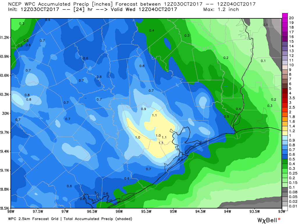
There are a few indicators of the easterly flow that’s been piling moisture into Houston during the last few days. The first one is that, if you’ve been anywhere near the coast or bays, you’ve seen water levels a couple of feet above normal. This is just the easterly winds piling water on top of high tide. The second factor is the increased humidity levels of the Gulf of flow. This increased moisture from the Gulf is likely to culminate later today in showers and thunderstorms. We are not too concerned about flooding, but much of the Houston area may well see about 1 inch of rain, give or take. Some isolated areas will almost certainly see more. If there are any concerns later today, rain wise, we’ll be on top of them for you.
Wednesday
A transition day, as showers end Tuesday night or Wednesday morning. Skies should clear out in the morning or early afternoon, with highs in the mid- to upper-80s.
Thursday through Sunday
It is not going to be cool this weekend by any stretch. But like last weekend, we are going to see some drier air work into the region, and this should help keep humidity levels down, especially by Saturday and Sunday mornings. These lower dewpoints will make mornings and evenings feel quite pleasant, although we can still expect sunny, daytime highs in the upper 80s, and morning lows only to bottom out around 70 degrees—perhaps a few degrees lower for inland areas.
Next week
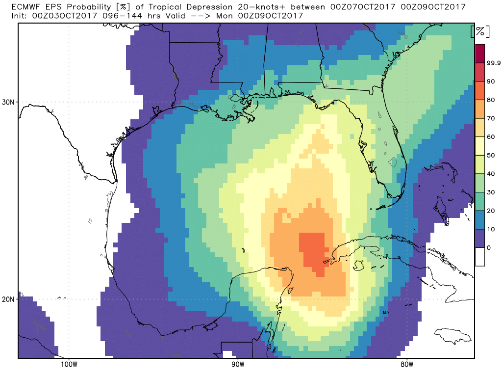
A tropical system may develop in the northwestern Caribbean Sea or southern Gulf of Mexico by this weekend, and it will probably move north. It’s not clear whether Texas will see any moisture from this, but it could bring some renewed rain chances by Monday or Tuesday.
We’re not too concerned about the potential for heavy rain early next week, and we have increasing confidence that a decent fall cold front will move through by around Tuesday. Hopefully parts of Houston will see lows in the 50s, but we’re not making any promises at this point. I’ll have a more detailed analysis of the cold front in tomorrow’s post.
Hi Eric, this system in the Caribbean/Gulf, is this the Central American Gyre that the weather channel posted about? Should we be concerned about hurricane development out of this?
We should not.
Thanks for the reassurance, Eric. We are looking forward to the end of this for at least 6 months. Harvey really traumatized us all.
your comment makes me feel better – was about to pack my bags
Did you see this? https://weather.com/storms/hurricane/news/tropical-depression-storm-caribbean-gulf-of-mexico-central-american-gyre
It looks like this thing may go into the gulf. Thoughts, Eric?
The vast majority of ECMWF tracks currently have it moving toward eastern Louisiana or Western Florida. That is where the majority of the rain is expected, regardless of development.
http://www.weathernerds.org/tc_guidance/storm.html?39912216
I can help you there, James. If a cluster of convection persists near an area of low pressure to kick off the formation of a tropical depression (and I think this to be likely) it will likely be pulled toward the toward the northern Gulf Coast sometime Sunday or Monday. That means that areas from New Orleans to all of Florida must be on guard. Current winds will not permit it to go to Tx.
However, I can’t help you on the rain chances. Can you help James out a little bit, Eric?
Thanks. I always like your no-nonsense approach to forecasting
You nailed today’s forecast. Nice job.
He sure did. There were some heavy rain spouts for a bit, but for the most part it was tolerable. Can’t wait for the upcoming cool front 🙂