Houston got a taste of sunshine to start the new year, but now we’ve returned to cloudy weather. Soon, rain will follow, and due to the nature of our saturated soils and lesser ability of dead vegetation to absorb rainfall, a flash flood watch is in effect through noon Thursday. We’re not overly concerned with the possibility of widespread flooding, but certainly the next day or so will be a wet, chilly affair.
Wednesday through midday Thursday
A combination of moisture streaming into the area from the Gulf of Mexico (this is occurring above the surface, because winds near the ground are out of the northeast), as well as a disturbed atmosphere will drive the potential for rain today, tonight, and Thursday morning. While much of the rain will likely be of the light-to-moderate variety, a few embedded heavier showers are possible. Moreover, because the rain could last for hours in some locations, we may eventually see accumulations of up to about 3 inches. Because soils simply cannot handle much (any) of this rain, almost all it will run off into streets and bayous.
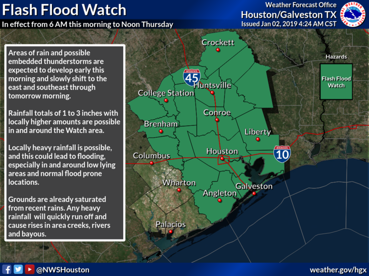
Overall, this messy weather should eventually move off to the east by Thursday morning, or early afternoon time frame, as a cold front moves through. Before then, highs will be in the 50s, lows in the 40s, and skies leaden. I know some of you love winter weather like this, so enjoy it while it lasts.

Thursday night and Friday
Skies will begin to partially clear Thursday night, with lows dropping down to about 40 degrees in Houston—cooler to the north, and warmer toward the coast. Highs Friday will be sunny, and in the mid- to upper-50s, under mostly sunny skies.
Saturday and Sunday
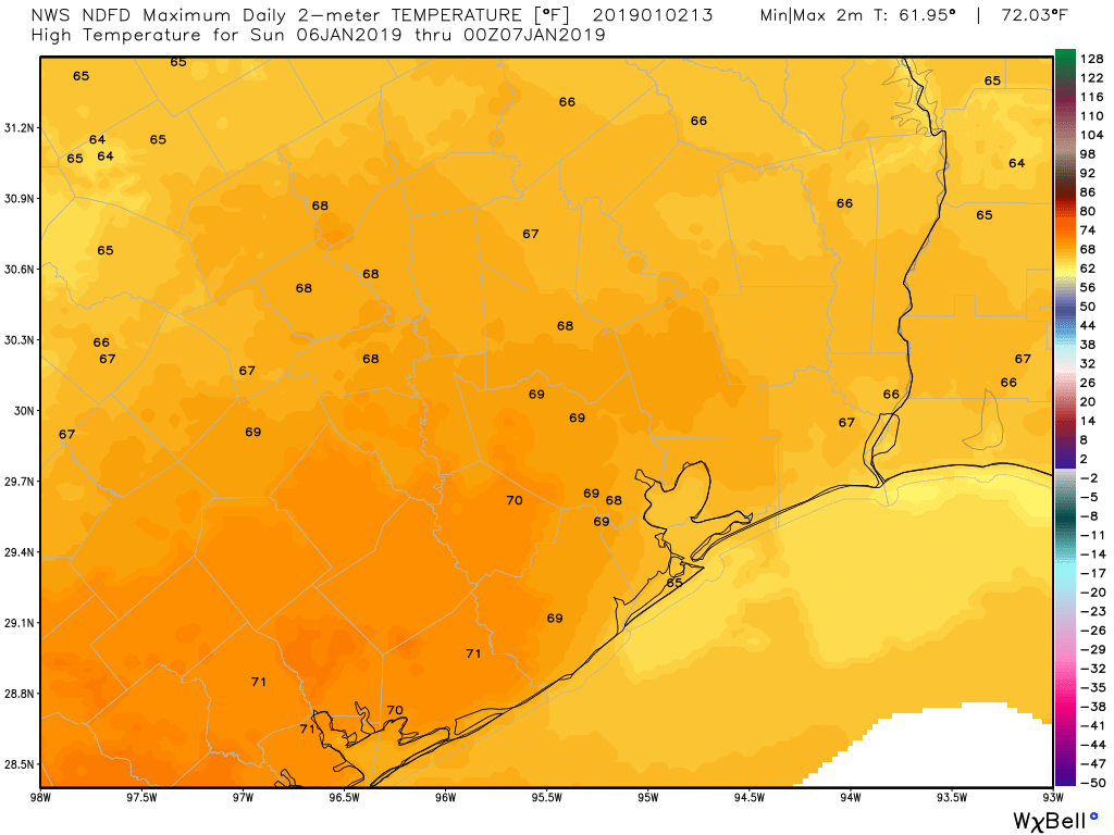
Just a gorgeous weekend on tap, with highs in the mid-60s to 70 degrees, sunny skies, and moderate winds. Lows Saturday night will be in the 40s, while Sunday night will be about 10 degrees warmer. Make your plans for the weekend with confidence.
Next week
The warm-up continues Monday, when highs likely will get into the mid-70s. However, another (probably weak-ish?) front will push through Monday night to cool things down a bit. Right now the models are advertising this as a dry to mostly dry front, so rain chances and overall accumulations should be fairly low with more sunny skies to follow.
blech! I love winter, but not wet winter. Oh well. Better than 100F? thanks for your work Eric and Matt!
Seriously guys – I need a bit of a drought so I can pressure wash the back patio and drive. I promised myself to do it between Christmas and New Year’s but I got no help from the weather.Right now it would just flow back as mud.
See what you can do, OK?
When will you begin feeding the weather obsession of the Houston Marathon runners?
My question also…
Not until Monday. By then we’ll be 13 days out, and the forecast will have some semblance of reality.
This yucky weather makes me want to go back to Los Cabos where I recently spent 9 days. Got back on 12/30
National Weather Service forecasts 1.13″ of rain at Bush Airport between noon and 6PM today, and an additional 1.17″ between 6PM today until 6PM tomorrow.