Houston is coming to the end of wet spell, but we’re not quite across the finish line. Generally, 1.5 to 3.0 inches of rain have fallen over the last 24 hours, which is not that much rain but due to sodden soils and dormant vegetation, none of those rains have been absorbed. (Area bayous are fine, with the exception of some minor flooding along Little Cypress Creek). Fortunately the bulk of this mess has moved off to the east, and the rest of it should follow by around noon today. Good riddance!
Thursday
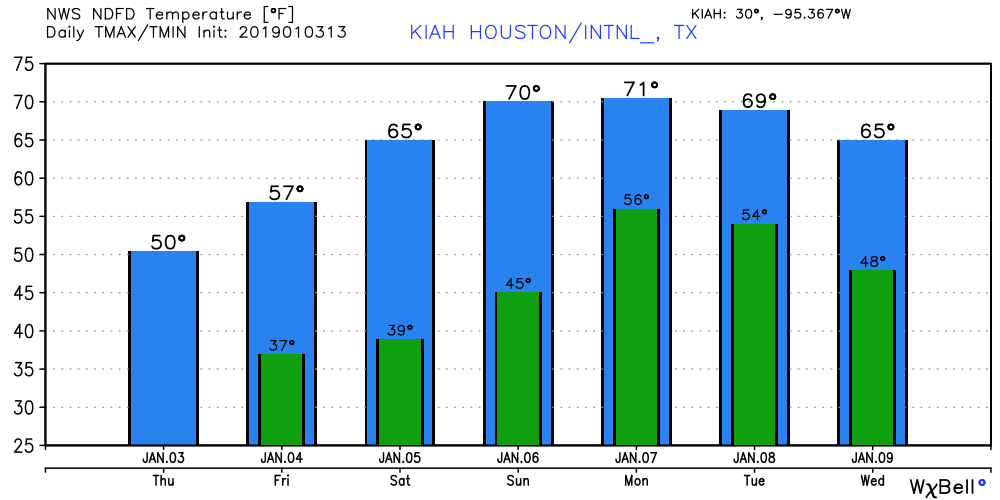
It’s chilly this morning in addition to the rainfall, with low 40s inland to mid-50s near the coast. As the upper-level storm system that produced our wet weather moves east, it will be replaced by high pressure later today that will bring drier air. Clouds probably will be breaking up around the time the sun sets. Highs today won’t move up much from lows this morning, and lows tonight may get into the upper 30s for the city.
Friday
After the cold start, sunny skies will help push temperatures into the upper 50s for most of the city, with light northerly winds. Lows Friday night will be a few degrees warmer than Thursday night, but still fairly cold.

Saturday
A beautiful weekend day for early January. Look for highs in the mid, or perhaps upper-60s, with sunny skies and very light winds. Get married with an outdoor wedding; eat lunch on the terrace, ride rides at Kemah, drink a beer at a Texans tailgate, walk along the beach, go for a long walk at Brazos Bend Park, drive with the top down—really anything is going to be good to go on Saturday. Lows will be in low 40s inland, mid-40s in the city, and low 50s near the coast.
Sunday
Still a nice day, with highs around 70, but we’ll probably see some returning clouds with onshore winds.
Next week
Highs on Monday will push up into the low 70s, probably, before the next front arrives. I’m not overly bullish with rain chances along this front, and most people probably won’t see much, if any precipitation with the front’s passage. It should knock highs back into the 60s, with lows in the 50s. Most of next week looks pretty mild and mostly dry.
Note
We intend to implement a site design change tonight, so if you notice anything out of place late tonight or early Friday, we’re working on it. Hopefully everything will be ironed out by Friday morning’s post.
You guys are ever faithful and I so appreciate it. I am thankful for you.
Happy New Year Eric and Matt, with thanks for the great work you guys do.
2” of rain in Tomball yesterday and 2” since 4am. We are water-logged out here in NW Harris County
Amen! Yard is a soggy mess – thank God for rain boots!
Brazos River today is at minor flood stage at Rosharon. Richmond gauge has not yet shown turn-over through Tuesday though curve is flattening just below minor flood.
The Brazos is within your “viewing area”, can you include its conditions in your comments on local streams and bayous in the future?
Certainly, Wendy. Thank you for the information on the Brazos River.
Yeeeehaaawww…pleasant Texan tailgating Saturday! Thanks guys!
Looks like a good weekend to ride my motorcycle!
Check that muffler!
Yes, indeed. Thanks, Eric and Matt, for your excellent and humorous approach to the weather. First thing I look at in the morning.! We count on you.Happy New Year!
1.97″ at my house in Champions since yesterday morning. Cypress Creek has risen 7-8 feet but it’s still pretty low. No street flooding around here.
My Space City umbrella did a nice job on shielding us from the rain. Thanks Eric and Matt! 🙂
Happy New Year, Eric and Matt! Thank you for your excellent work. I have recommended you to numerous people, all of whom are now as devoted as I am. I also would appreciate news of the Brazos River. I live in Lake Jackson and substitute that for when ever you say “along the coast”, but would love some more detailed info about our weather. Keep upmthe good work!
Can you comment on this polar vortex split I’ve been reading about which may mean colder than normal temps coming up? What’s the possibility of this?
Thanks for the detailed weather analysis. I am doing an outdoor show next Saturday (1/12). Any ideas on rain chances that far out yet?