Dry air poured back into Southeast Texas yesterday, and despite high temperatures near 90 degrees, it really didn’t feel bad at all. In fact, dewpoints dropped into the 50s officially at IAH Airport for the first time in June since 2017. We’ve got one more day of this nice stuff today before we return to more standard summer.
Today
Sunshine dominates once again. With dry air in control, we should again see humidity drop to near “comfortable” levels for many parts of the area. Look for high temperatures to pop back to 90 or better for most, however.
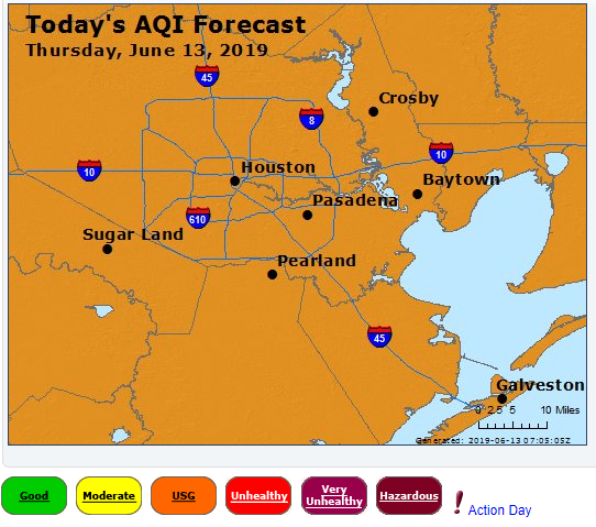
Winds will again be on the light side, so expect air quality to be fairly stagnant once again. While not as bad as Wednesday, today will again be an ozone action day, with poor air quality this afternoon. If you’re in a sensitive group or struggle on bad air quality days, take it easy and try to stay indoors later today. If you’re ever curious about the air quality outlook, the Texas Commission on Environmental Quality publishes 4-day forecasts each day. You can bookmark that link here.
Friday
Look for another sunny day tomorrow. The difference will be in the humidity. Dewpoints are expected to slowly rise late tonight and most of the day Friday, and they should end up back around 70, or uncomfortable, by Friday evening. Expect us to start the day pleasant (mid-60s) and finish hot (low-90s). Air quality will improve a bit as onshore winds kick up during the day.

Weekend
We are still on track to return to summer this weekend. Look for high humidity, daily shower chances, and breezy weather. Expect morning lows to be in the mid- to upper-70s or low-80s and daytime highs in the low-90s. It will be breezy with 10 to 20mph winds and higher gusts over the open water. Use caution if you’ll be out boating in the Gulf or on the bays this weekend.
The combination of heat and humidity will also raise heat index values, so take it easy in the late afternoons and drink plenty of water.
In terms of rain chances, both Saturday and Sunday will have at least a scattering of showers in the afternoons, mainly as the sea breeze works inland from the Gulf. There will be an added disturbance very late Sunday or Sunday night to our north that could enhance some showers or storms up that way. But that will likely not interfere with any daytime plans.
Next week
Additional disturbances and daily shower or storm chances along the sea breeze will keep afternoons and evenings unsettled next week. Most of the day prior to that will see sun and clouds. Expect upper-70s to low-80s at night and low-90s during the day. A day or two could push mid-90s as well, along with plenty of humidity. The forecast is reminiscent of what is typical for summer around here.
So, if I see some ozone, what sort of action am I to take? Call 911?
Matt…in the AQI graphic what does “USG” mean? Thanks…
Guessing – “Unhealthy for Sensitive Groups”
Gena’s comment is correct: Unhealthy for sensitive groups. You can read more about ozone here: https://cfpub.epa.gov/airnow/index.cfm?action=gooduphigh.index
Will the incoming African dust affect temps or humidity this weekend?
No. This doesn’t appear to be a significant dust event, though you may notice the color of the sky dull a bit at times.
Why is it that it seems, at least, every time we get dry, refreshing air in the summer, the quality of the air comes with warnings? What drives that?
Ozone forms in the presence of a lot of sunlight, so days like this, without much of a cloud in the sky help that to happen. Typically, that’s what you get with drier air so it’s just kind of an unfortunate combo. But when you have dry high pressure overhead, you usually have a lack of wind. That also helps ozone to form. So we’ve got a ton of sun, dry stable air, and not a lot of wind…in an urban environment with a lot of pollutants in the background, it’s pretty much a ripe recipe for ozone to form. You can read more here: https://cfpub.epa.gov/airnow/index.cfm?action=gooduphigh.index
Matt, thanks much. Always interested in this type of information.
I saw an article today about the new/upgraded NWS prediction model GFS-FV3 https://www.washingtonpost.com/weather/2019/06/12/national-weather-service-launches-upgraded-improved-global-forecast-model/?utm_term=.58f772b1f1ca Hope it helps with hurricane predictions!
I am guessing that climate change must add in additional challenges to weather forecasting, too.
Yes, the new model should, theoretically do better, but truthfully, it will still lag the better quality data from the Europeans. We’re making strides at improving, but we still have far to go. As far as climate change goes, that’s not something we really consider with day to day forecasting, so it doesn’t have much impact from that point of view. It impacts thinking with monthly forecasts or things like that…but on the day to day level, there are too many other more impactful things to worry about when making a forecast.