After a week that saw one of the longest June stretches of relatively comfortable humidity in recent memory, we will shift back into the thick of summer today and this weekend.
Today & weekend
Look for sunshine and some clouds today. We’ll top out in the low-90s once again, and humidity, though still relatively low for June, will begin to inch upwards. As of 5 AM, we ended a streak of 71 consecutive hours at Bush Airport with dewpoints of 70° or lower.
#Houston wrapped up a 71 hour streak of dewpoints of 70° or lower at 5 AM this morning.
— Matt Lanza (@mattlanza) June 14, 2019
We talked a little more about dewpoints earlier this week.
Beginning tomorrow, with the humidity back in force, we can expect clouds, sun, and at least a few showers or a thunderstorm along the sea breeze as it lurches inland in the afternoon. I suspect most of us will be dry Saturday, but you’ll want to have the umbrella nearby to be safe. The morning starts in the mid- to upper-70s, and the afternoon will top out in the low-90s.
Sunday poses a trickier forecast, as the environment looks a bit more favorable for scattered showers and thunderstorms inland. We’ll likely see some activity along the sea breeze again as it moves inland from the Gulf, but we’ll also see a scattering of inland storms, especially north of I-10 and west of I-45. Temperatures will be a little warmer in the morning Sunday, bottoming out in the upper-70s or near 80 degrees. The afternoon should be near 90° where it rains or in the low-90s elsewhere.
Air quality, dust, and wind
I want to briefly focus on some other issues this weekend.
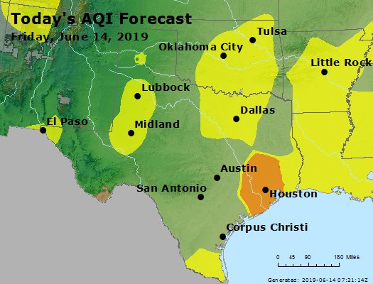
Air quality: Another ozone action day is in effect today, which means air quality is going to be unhealthy for sensitive groups. That said, it should not be quite as high as it was yesterday because winds should be a little stronger today. But those in sensitive groups (particularly elderly, children, or folks with lung or respiratory ailments) should take it easy and try to stay indoors when possible, especially in the afternoon.
Dust: Saharan dust! It’s back! Look for the first real Saharan dust cloud of the season to reach our shores Saturday morning. The dust should dissipate on Monday. This should only be a minor dust event, but it could mean the color of the sky dulls a bit; think more gray than blue, even without clouds. Sunsets and sunrises could be a little bit more interesting looking.
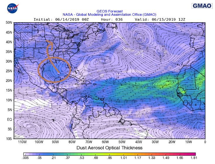
You may notice more haze than usual or even a little irritation if you have allergies or respiratory ailments. We may get another minor dust event around midweek.

Wind: Onshore flow will be rather strong this weekend. Look for breezy conditions, with sustained 10-15 mph winds, and gusts of 20-25 mph possible, particularly over the open water. So if you’re out on one of the lakes in the region, Galveston Bay, or the Gulf, exercise caution this weekend.
Next week
Sort of a rinse and repeat pattern is expected next week. It will be hot and humid all week long, with highs of 90+ likely each day, and lows in the upper-70s for most. The heat will periodically be broken by some cooling showers and storms. Look for a normal summer pattern of morning showers at the coast, spreading inland with the sea breeze each day. We’ll also have a couple disturbances rolling through, especially early in the week that could touch off some additional scattered inland storms. It won’t be a wild week, but it should be active at times. Have the umbrella dusted off and ready. Eric will be back Monday, and he’ll fine tune these rain chances a little more for you. Enjoy the weekend!
Dewpoint is 67 degrees at my house this morning. It’s 64 at Hooks.
Thanks Matt!
Happy Friday everyone!
Saharan dust time already? This last year really flew by.
Any thoughts as to intense rain on Monday? Looking to take my in-laws to the Woodlands Resort for pool time and wondering if I need a back up activity….