After back to back days of misery for many in the Houston area once again, we *may* finally have a quieter day (or more) to exhale here. Today looks drier and calmer. Unfortunately, we still have residual problems to discuss and more storms down the road. But for now, let’s revel in the goodness of dry weather. Read on for the latest.
MORE HISTORIC FLOODING
First, let’s discuss the past and its impacts. Our newest contributor, Braniff Davis, will have more on why things happened later in the weekend or early next week. But the bottom line is we still have major issues in the area.
The most severe problems right now are along Spring Creek, which is experiencing flooding levels not seen before (worse than April, worse than 1994, worse than Allison in spots).
Devastating flooding ongoing along Spring Creek. #houwx #hounews pic.twitter.com/YfqMzpE7Mc
— Jeff Lindner (@JeffLindner1) May 28, 2016
As Jeff said, this is a truly devastating event, made worse by the fact that so many of these folks saw such severe flooding one month and change ago. Spring Creek at Spring will crest later today or early tomorrow. Flooding also continues along Cypress and Little Cypress Creeks, some of it bordering on major, but under levels we saw in April. Those areas are close to cresting this morning if they haven’t already.
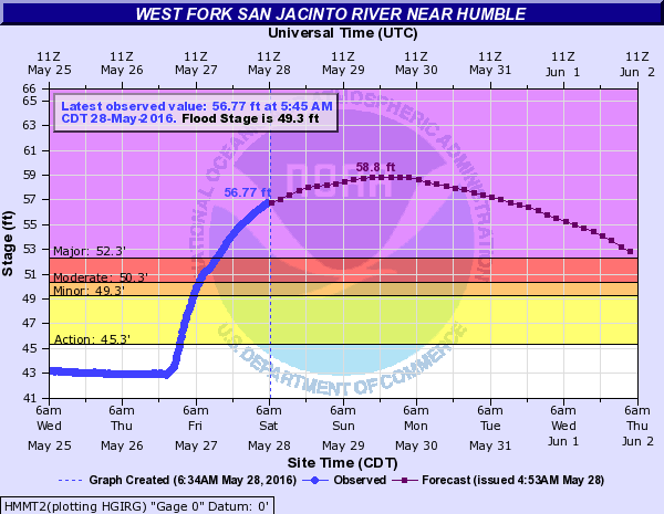
Lake Conroe is closed (at least temporarily) this weekend due to dangerous conditions. The West Fork of the San Jacinto River at Humble is expected to crest just under 59′ later Sunday or early Monday, which means that major flooding there will still worsen a bit.
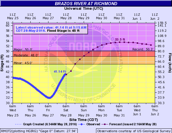
The other big issue is going to be the Brazos River west of Houston. With all the runoff from the College Station-Brenham area flowing into the river, it will rise steadily all weekend. At Richmond, the Brazos should crest over 3 feet higher than the previous record (yes, this means higher than any of the past events since last Memorial Day). The crest is expected later Monday or early Tuesday.
Bottom line: While this is a holiday weekend, you will need to use caution and possibly need some extra patience, especially if your travels take you north and west of Houston. Never drive around barricades, even if things look safe, as this sort of flooding can cause a lot of structural damage to roadways. They’re there for a reason.
TODAY
Any fog around this morning will dissipate. And we’ll turn mostly sunny if it isn’t already. Is this ever a welcome sight. Though we expect a much quieter day today, with all the moisture we’ve received and perhaps a lingering boundary or two (and a late day Gulf breeze perhaps), a few of you may see a downpour or strong thunderstorm this afternoon. They will just be much more hit and miss than what we’ve seen lately. There will be a better chance this afternoon or evening out in Hill Country. High temperatures today reach the upper 80s (cooler at the coast).
Sidebar: We still have yet to officially hit 90 degrees at IAH. Last year, May 28th (today) was our first 90 degree day. If we can avoid too many clouds and storms this weekend, we have a shot at pushing it. If not, it may wait til next weekend.
SUNDAY/MONDAY AND NEXT WEEK
Sunday and Monday may behave similarly with some pop up thunderstorms here and there (at this point, nothing widespread is expected). High temps will be in the upper 80s to near 90 degrees both days. We’ll keep an eye on things for you this weekend.
Unfortunately, the weather pattern is likely to turn active again in East Texas next week, with several rounds of showers and thunderstorms likely Tuesday through Friday. The timing and specifics are impossible to say much about yet, but it’s something we’re watching.
If there is good news it’s this: Light at the end of the tunnel. I’m seeing signs that a more stable, summer pattern may finally emerge by next weekend or so over much of Texas. Yes, this means summer heat, but it should also mean drier weather. And while in Texas you need to be careful what you wish for, a dry period is desperately needed right now.
Posted at 7:20 AM by Matt Lanza
Going back to last Memorial Day, the Houston area has had three catstrophic storms, none of which were associated with hurricanes or tropical storms. Is that unprecedented?
I think it’s more a case of bad luck and bad timing than anything….random chance. I assume this has happened before, given the amount of flood events recorded in Houston historically. But I also assume this large an impact 3 times in ~1 year is a pretty rare situation. A long list of past flood events is here: http://www.wxresearch.com/almanac/houflood.html
Is the powerful El Nino this year also a possible contributor (I think it is winding down though)? I do know that El Nino gives Texas additonal precipitation.
Yes. There’s no question that is a likely contributor. The event itself is just about dead, but there are likely lingering impacts (and certainly 2015’s events were enhanced by or related to it).
Do y’all know how many lightning strikes we had in Clear Lake last night? Here in Oakbrook they seemed to come every few seconds for a while, a long while..
I just looked back at lightning density maps from last night. I can’t give you a number, but suffice to say it was somewhere between “a lot” and “a whole lot.”Looks like much of the area saw 1-2 strikes per square km every minute. Metro Houston is 26,000 square km. So that’s a big time number.
It might be instructive to see modeling of what would have happened if this latest event had trained just a short distance south / southeast of where it did, i.e., closer to the Houston metro core. What if Katy had gotten 19 inches instead of Brenham? What would our stream profiles look like in that instance?
I realize I’m potentially opening the door to Katy jokes, but my question is serious. I’m thinking of the reservoirs.
No question you’re right to ask this. And I’m sure this is being done somewhere in a back room on a computer. Unfortunately we can only speculate. But given the levels of Addicks Reservoir, I sort of shudder to think what could have been here if this event shifted 30-60 miles south and east. It would not have been good, that’s for sure.
Will this lead to another round of severe flooding to the city’s north, Eric?
Eric, I’m shuddering to think I sort of shudder to think what might be here Tuesday through Friday if these rounds of thunderstorms take place 30-60 miles south and east of the locations impacted by Friday’s event. I’d like to know if you have any thoughts about that possibility. Do YOUpersonally feel another extreme event likely?
I think we may have just missed our first 90* day this year, but the thermometer sure seem to stick at 89* for a long, long time. Even though last year’s first 90* day was May 28, I consider that we’ve already broken last year’s record due to the Leap Year. The first 90* day last year was Day 148; today is Day 149 due to the Leap Year. If you accept my method of counting days, 2016 has the latest “first 90* day” since 1983. And if we did indeed escape today without hitting 90, we’ll tie the 1983 mark tomorrow at Day 150.