In brief: Other than some periods of poor air quality, the forecast for Houston is about as perfect for springtime as it gets with sunshine and low humidity through the weekend.
Today through Sunday
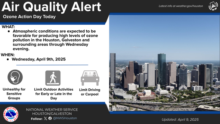
This is really going to extend an incredible stretch of sunny weather here in Houston. Very few clouds are expected over the next 5 days, with sunshine each day. You will see and hear about air quality advisories. The plentiful sunshine tends to interact with pollutants from cars and petrochemical facilities to produce ground ozone. You can read more about this here, but suffice to say, there will be periods of unhealthy air quality in the morning or evening, especially today, tomorrow, and Friday.
(NWS Houston)
Temperatures will flop around a bit. We’ll do low 80s today, mid-80s tomorrow and Friday, low to mid-80s on Saturday, and then mid to upper-80s on Sunday. Morning lows will be in the 50s or 60s. Overall, this will also be a fairly pleasant, dry air mass. Humidity will increase some this weekend but not to levels that would be deemed uncomfortable.
Next week
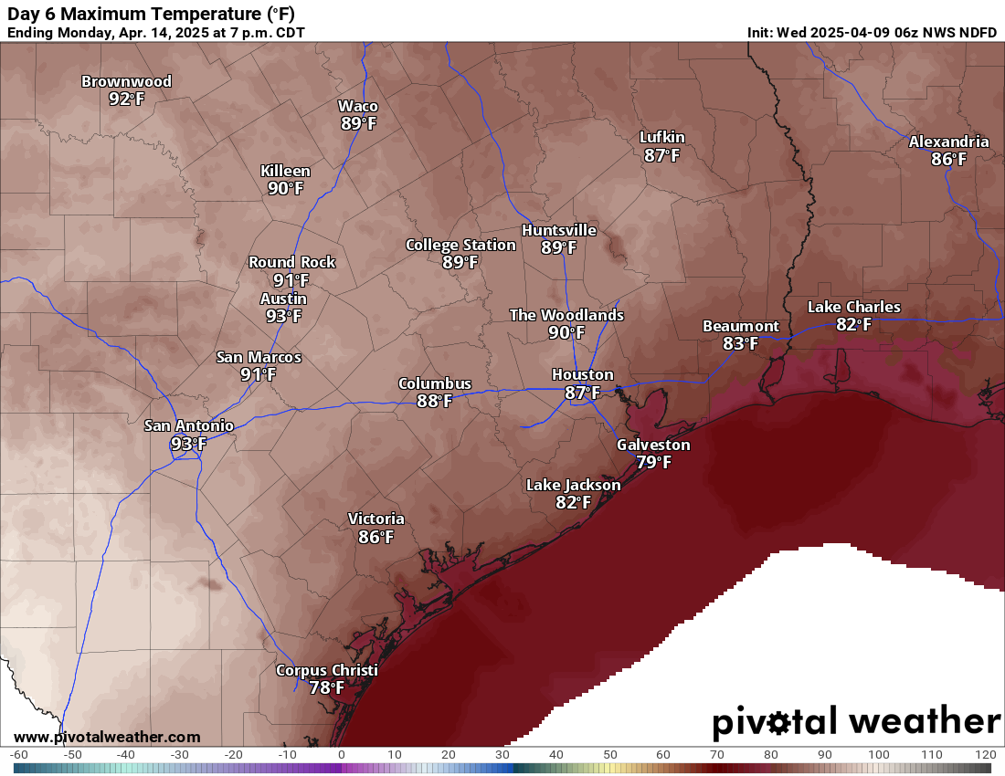
Even next week the pattern doesn’t change a whole heck of a lot for Southeast Texas. We should see more humidity, a little bit more in the way of cloud cover, and eventually some additional storm chances. Those probably don’t become really notable until later in the week. Temperatures should start to increase some and push 90 degrees by Monday or Tuesday.
Temperatures could begin to push 90 degrees by early next week. (Pivotal Weather)
Bottom line: Enjoy this week’s stretch because you never know how many more like this we’ll get before summer sets in.
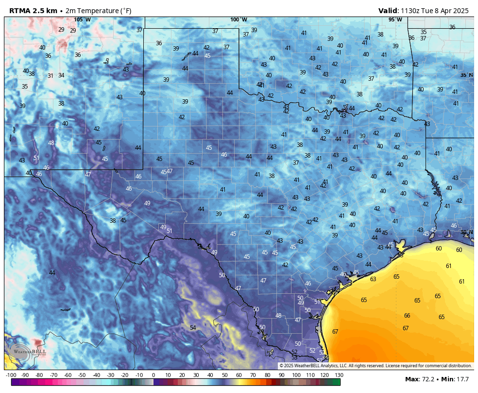
In brief: It’s rather cold across the state of Texas this morning, with nearly all of the state in the 30s and 40s outside of The Valley. Because we’re nearing the middle of April, the cold weather will not last, and indeed I don’t think it will get this cold in Texas for the next six months. Expect warmer temperatures for the rest of the week, but high humidity will remain at bay for awhile.
It is a cold morning across Texas. (Weather Bell)
Midway through spring
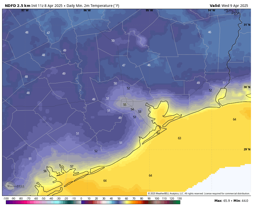
Spring is by no means over for the greater Houston area, as temperatures outside this morning demonstrate. Pretty much the entire metro area outside of areas far inland (Conroe, 38 degrees) and Galveston (56 degrees) has fallen into the low- to mid-40s this morning. This is by no means extraordinary, as the record low temperature for today in Houston is 35 degrees, set back in 1971.
However, temperatures this morning are still running about 10 to 15 degrees below normal for this time of year, and looking ahead at the next two weeks I do not see another strong front in the cards. Therefore, for the urban core of Houston and areas closer to the coast, I expect that this morning may well be the final morning in the 40s of this season. We may not see its like again until October, or even November.
Tuesday
Miracle of miracle, the winds this morning are calm across the region, and are likely to remain so today. With sunny skies we should warm into the mid-70s this afternoon, with continued very dry air. Seriously, today is going to be one of the nicest days of the year, with exceptional weather. Lows tonight in Houston will drop into the lower 50s for most locations. Areas west and north of the city should dip into the upper 40s once again.
Inland areas to the west and north of Houston will have another shot at the 40s on Tuesday night. (Weather Bell)
Wednesday
Wednesday will be a slightly warmer, and a slightly more humid version of Tuesday. We are talking high temperatures of about 80 degrees, and lows dropping to about 60 degrees on Wednesday night. Winds will have turned to come from the south, at perhaps 5 to 10 mph.
Thursday, Friday, Saturday, and Sunday
We should see sunny skies throughout the rest of the week, with high temperatures varying between 80 and 85 degrees. A weak front arrives on Friday morning to knock some of the humidity out of the air, but overall with dewpoints in the 40s and 50s the air is going to feel modestly dry. Nights should, generally, fall to around 60 degrees with inland areas a bit cooler and the coast a bit warmer. By Sunday we may see southerly winds become more pronounced, with gusts of 20 to 25 mph possible.
Next week
Next week should be a little bit warmer, with a few more clouds. I think we will be in the 80s for the most part, with nights in the 60s. There will be some humidity, sure, but it won’t feel like Houston humidity can during the depths of the summer. As for rain chances, overall chances are quite low until next Thursday or Friday, at least.
In brief: The word for the next week is tranquil, and there’s just not much to be concerned about as Houston enjoys one of its nicest periods of weather for the year. Winds will finally die down, and humidity should remain low through most of the weekend. Temperatures will, for the most part, be mild.
About those winds
The first week of April has been rather windy. First, we experienced robust onshore winds in response to an inland low pressure system. Then, beginning Saturday, winds turned sharply northward in response to the passage of a front. During the first six days of this month, the average wind speed has exceeded 15 mph, which is about 50 percent higher than normal during April. Every day so far this month has had a wind gust of at least 30 mph, and maximum gusts have exceeded 40 mph on several days.
Much of Texas experienced wind gusts of 40 mph or higher this weekend. (Weather Bell)
There has been one benefit of this, however. It has shaken much of the tree pollen, particularly from oaks, down to the ground. We are therefore rapidly nearing the end of tree pollen season. In any case, winds should now die down as Houston’s weather turns more tranquil, and it is possible that we won’t experience a day this week with a gust of 30 mph or higher.
Monday
Temperatures have bottomed out in the mid- to upper 40s this morning, and it feels rather chilly outside. However, we’re going to see plenty of sunshine today and, indeed, for the rest of this week and that will help warm things up. Look for highs in the mid- to upper-60s today with very dry air in place. Winds will be from the north at 10 to 15 mph. We will likely experience one more night in the 40s tonight, so if you like cold weather this is a night to really soak it all up.
Tuesday
We’re going to be warmer, with highs in the mid-70s, and very light winds. This is likely to be one of the 10 finest days of the year, weather-wise, in Houston. Skies will be sunny, with low humidity. Lows on Tuesday night will drop into the low- to mid-50s. Seriously, I challenge you to find something to complain about (the weather, at least!) Be sure and tell any out-of-town visitors that this is what it’s always like in Houston.
Temperatures will again be rather chilly on Tuesday morning. (Weather Bell)
Wednesday
More sunshine. We’ll continue our warming trend with daytime temperatures of around 80 degrees. Lows on Wednesday night will fall to around 60 degrees. This really should be another splendid day with reasonably low humidity.
Thursday, Friday, Saturday, and Sunday
The rest of the week and into the weekend should continue to bring mostly sunny skies. Daytime temperatures will be in the vicinity of 80 to 85 degrees, with nights in the upper 50s to lower 60s. A weak front should arrive on Thursday night or Friday to blunt rising humidity levels, so our air should remain somewhat dry through the weekend. Honestly, there are just zero weather concerns this week at all.
Next week
Most of next week looks warmer, in the 80s and with more humid nights. Our overall rain chances appear to be quite low through at least the middle of next week. We have not seen our last front of the season, but one seems unlikely to push through Houston until at least the weekend of April 20 or so. Speaking of April 20, I don’t yet have a good read on weather conditions for Easter Sunday in Houston.
In brief: Showers and storms will cross the Houston area through mid-afternoon, with some possibly on the stronger or even severe side. Hail and gusty winds are the main concerns. It will turn sharply cooler this evening with gradual clearing tomorrow.
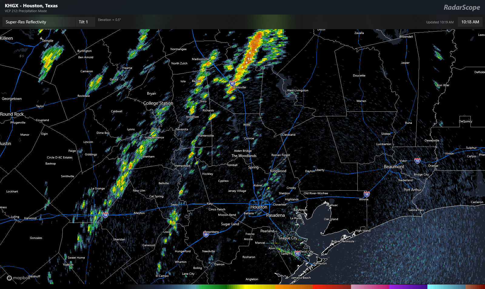
Things are quiet around Houston this morning, with just a few showers and a couple rumbles of thunder up near Huntsville. Otherwise, we have just a broken line of showers and embedded thunder on a line between about College Station and Columbus to our west.
A radar capture at 10:15 AM showing mostly broken showers and a little thunder north and west of Houston. (RadarScope)
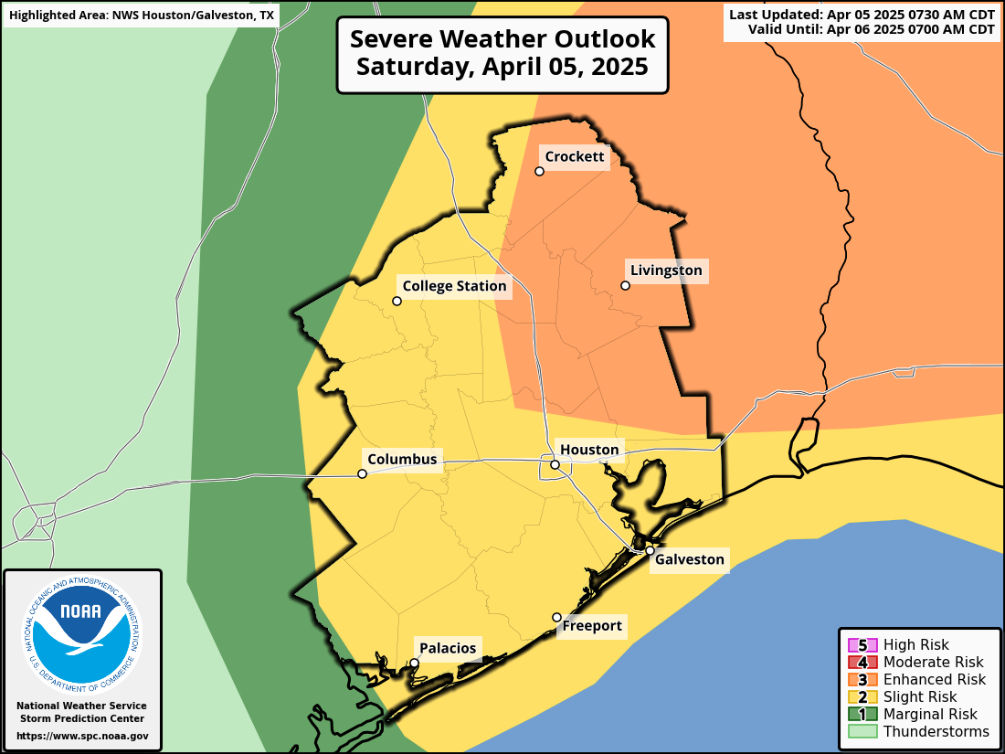
Over the next couple hours, this “line” will move eastward, probably arriving in the Houston area itself around 12 to 2 PM. As the storms come east, the storms will likely strengthen some. That’s when we will see some heavier downpours, a little more lightning, and perhaps some 40 mph wind gusts. One or two storms could become severe with large hail, more damaging-type winds (60 mph) or even a very isolated tornado (mainly east of Houston). Those severe storms look to be the exception rather than the rule this afternoon, but we’ll continue to monitor things. We are in a level 3 of 5 (enhanced) risk northeast of Houston today for severe weather.
Severe risks were nudged up a little today to the northeast of Houston. (NOAA SPC)
In addition to keeping an eye to the sky, keep an eye on the thermometer, especially this evening. Temperatures will peak in the 80s early this afternoon before dropping back into the 60s this evening and 50s before midnight. Out will be the humidity, in will be the light jacket. There will also likely be periodic showers this evening, possibly even a rumble of thunder or two. Things gradually clear out Sunday.
Just keep an eye on the weather today, but aside from one or two isolated severe storms, we do not anticipate things getting out of control.