In brief: Houston’s daily storm chances will remain high the next couple of days, with activity likely peaking during the afternoon hours. Also, we discuss a rare phenomenon observed on Tuesday, when clouds formed directly over the region’s freeways!
Visible satellite image at 8 am CT on Tuesday. (Ethan Mok/X)
Freeway induced clouds
Yesterday a storm chaser named Ethan Mok shared satellite images from around 7 am to 8 am CT showing Houston in the visible spectrum. In them, remarkably, clouds lined up directly over most of the freeways in the greater Houston region. Quite clearly these interstates, particularly the Katy Freeway with its more than two dozen lanes, were inducing their own micro-climate.
Anyone ever seen interstate-induced clouds before? Low level CU developed perfectly along major interstates around Houston this morning. Kind of shocking to see such perfectly lined up clouds. #txwxpic.twitter.com/cn1BWf2wqL
I’m not sure precisely what is happening here, but it must be a combination of several factors. Winds on Tuesday morning were very light, allowing heat from the concrete surfaces (which were warmer than the surrounding air) to rise almost straight up. In addition, particulates from vehicle exhaust provided nuclei for water vapor to condense around, creating seeds for clouds.
We don’t, frankly, understand exactly why it happened on Tuesday morning, or whether this is a particularly common feature. I have never seen a manifestation like this, however. It does highlight that one of the more active areas of meteorology research is how cities change weather. A recent study, co-authored by a Texas A&M University atmospheric sciences professor (and friend of the website) named John Nielsen-Gammon, found that cities can boost pop-up thunderstorms.
Wednesday and Thursday
We saw widespread showers and thunderstorms on Tuesday, with some of the more efficient cells producing upwards of 2-3 inches of rainfall. Our overall pattern will remain similar for today and Thursday. Most of the area is likely to see rainfall during the next 48 hours, but amounts will vary significantly, from low tenths of an inch to 1 to 2 inches. Like on Tuesday, some of these thunderstorms could briefly turn severe as they rumble through. Skies will be partly sunny during the afternoon, with highs likely in the mid- to upper-80s.
NOAA rain accumulation forecast for now through Sunday. (Weather Bell)
Friday, Saturday, and Sunday
We’ll see continued rain chances this weekend, however the daily likelihood of showers will probably fall back to around 30 to 50 percent each day, with any storms most likely to develop during the afternoon hours along with peak heating. Highs each day will be in the vicinity of 90 degrees, a little warmer inland and a little cooler closer to the coast. I could see this forecast trending a little drier or holding the same in terms of rainfall. Hopefully we’ll firm things up by tomorrow’s post.
Next week
The most likely outcome for next week is that Houston temperatures go up a little bit, with highs in the lower 90s, and our daily rain chances fall back to something like 20 or 30 percent daily. Such a pattern would be very typical for early- to mid-June.
In brief: A stormy pattern will descend upon Houston through Saturday or possibly Sunday. We don’t expect serious flooding, but there will be plenty of showers and thunderstorms to go around, especially during the afternoon hours, so remain weather aware in the coming days.
Stormy pattern
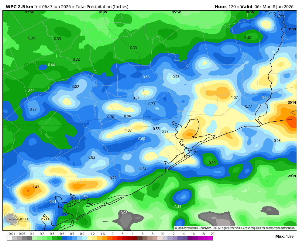
Houston will see a mish-mash of boundaries, weak fronts, sea breezes, and disturbances that will combine with an atmosphere filled with moisture for the rest of the week to produce a daily chance of showers and thunderstorms across the region. Chances each day will vary from about 40 to 70 percent, and there will be the usual pattern of hit-or-miss showers. Overall most of the region will probably pick up 0.5 to 1.5 inch of rain, but given the background moisture available some areas could see higher bullseyes of 3 or more inches. All in all we don’t expect much in the way of flood impacts, but this could prove disruptive to outdoor activities.
Rain accumulation forecast from a blend of models for now through Sunday. (Weather Bell)
Tuesday
At sunrise this morning we’re tracking some storms off the to east of Houston, on the far side of Galveston Bay. These may drift westward, into Houston, during the morning hours, primarily south of Interstate 10. Then, this evening and into the overnight hours, a weak front may produce a broken line of storms that drop down from the north and into the city. Whether these storms hold up all the way into Houston is not entirely clear, but thunderstorms are possible later this evening and overnight. At this time nothing with these storms looks to be too severe. Highs today should be in the vicinity of 90 degrees, with partly to mostly sunny skies. Lows tonight will drop into the mid-70s.
Wednesday
This should be a mostly sunny day with temperatures again reaching up to around 90 degrees. There is something like a 50 percent chance of showers and thunderstorms.
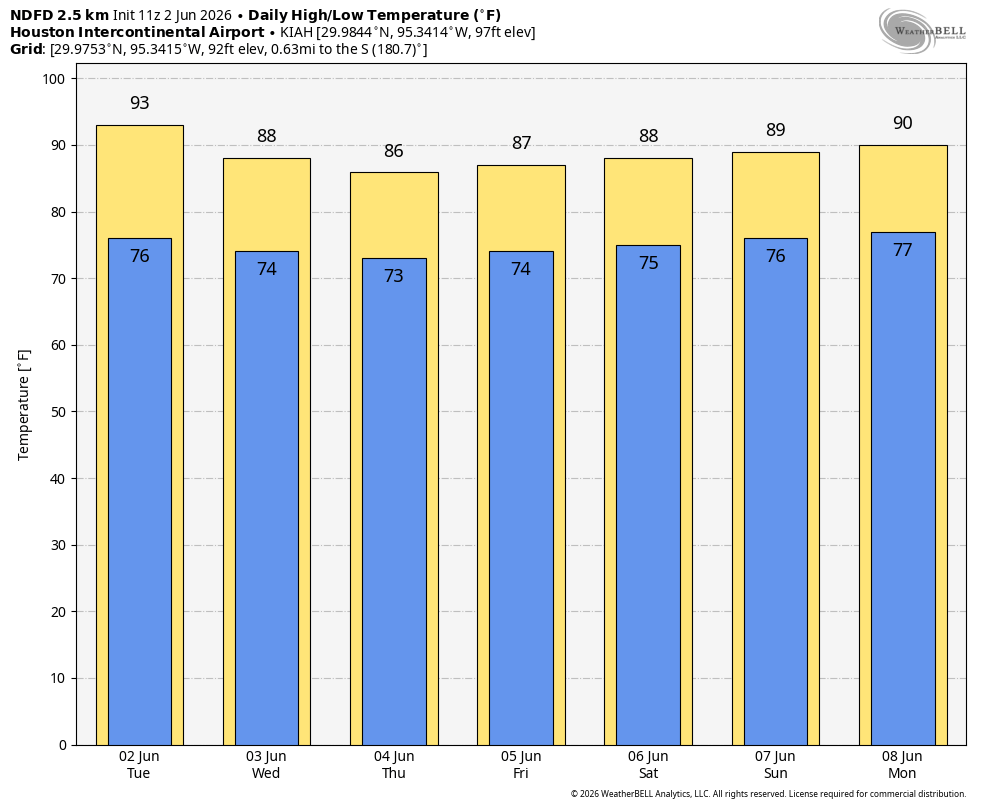
Our region’s daily highs will be fairly moderate for early June. (Weather Bell)
Thursday, Friday, Saturday, and Sunday
During this period of time we are likely to see partly sunny days, with high temperatures ranging from the mid-80s to around 90 degrees. Temperatures will depend on the extent of cloud cover during the afternoon hours, and when showers and thunderstorms roll through. We expect to see periodic rounds of showers, but again there will also be plenty of breaks with some sunshine as well. Storms will be most active during the afternoon and early evening hours, with peak heating. Nights remain quite warm, in the mid- to upper-70s. As we get closer to the weekend we should have some better details about what each of these days looks like, but for now we expect to see a situation in which, during the afternoon, we see storm-o-clock descending upon the region.
Next week
The most likely outcome next week is a little more sunshine, a little less rainfall, and highs around 90 degrees. But do I feel particularly confident in that outlook? I do not.
In brief: Well, here we are. The start of the six-month Atlantic hurricane season. In this post we attempt to give you the information you need about what to expect and how to prepare, without raising your anxiety too much. A little preparation now will go a long way if the worst happens.
Hurricane season forecast
We do not put a whole lot of stock in seasonal hurricane forecasting. It can provide a general sense of what is likely to happen, but there is no precision in the details that matter. For example, what we really want to know is whether there will be a lot of active storms in the Gulf of Mexico, not the central Atlantic Ocean. And since we remain a couple of months away from the ‘peak’ of hurricane season we just cannot know these details.
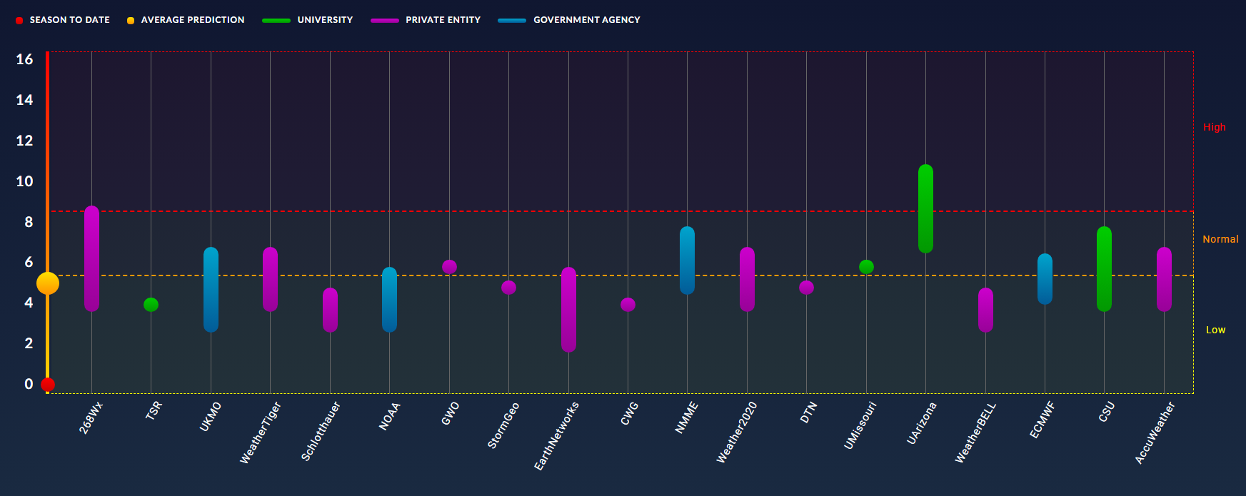
Seasonal forecasts for the Atlantic basin in 2026. Click to enlarge. (Barcelona Supercomputing Center and Colorado State University)
With that said, the general consensus from hurricane season forecasts is that we should see activity levels below normal this year across the Atlantic basin. For example, the average number of named storms is about 14 per season, and this year the most likely range of named storms is between 8 and 14, according to NOAA. The average number of hurricanes is 7, and the expected range is 3 to 6. So this is good news, because fewer storms overall mean fewer “shots on goal” when it comes to striking the Texas coast.
The reason for all of this is that El Niño is very likely to develop soon, and strengthen during the key August and September months. This should help to suppress Atlantic storm activity by increasing wind shear. There are other reasons as well, but the takeaway message here is that instead of seeing a blockbuster season, we are likely to see a quieter one. But a quieter season for the entire Atlantic does not mean a quiet season for Texas if one or two storms threaten here. So as ever, we will remain vigilant here at Space City Weather.
What you should do to prepare
The most important piece of advice we can give you at Space City Weather is to have a plan for what to do if a storm threatens. If you have a plan, then you’ll sleep better and night, and be prepared to put it into action. And this is important, because when a hurricane legitimately does threaten the Houston region, people lose their minds. You don’t want to lose your mind.
The key question you need to decide is under what circumstances you will evacuate. An important factor in all of this is how close you live to the coast. The Houston-Galveston Area Council has some excellent resources to help you prepare at this website. Among them is a “zip-zone” map that helps homeowners identify their vulnerability to different levels of storm surge. This is also how evacuations will be called, by zip codes.
Evacuation zones by area: purple (coastal), yellow (A), green (B), and orange (C). (HGAC)
There are other determinants for whether one should evacuate. Winds are a secondary consideration. In Houston that almost always means extended power outages. If you’re not prepared for that, or have someone in your home with a medical condition that requires electricity, then you definitely will want to be prepared to evacuated if a hurricane threatens the Houston area.
For those planning to stay during most storms, here is an example of a good disaster kit checklist. A lot of this is common sense: what supplies would you need to remain in your home for several days, without power, and without access to outside resources? Also please don’t forget about pets, whether you’re staying or evacuating. Also it’s a good idea to check on neighbors. One of the only silver linings of a hurricane, I have found, is that it tends to bring neighbors and neighborhoods together.
A final word. Hurricane season is a long slog, not a sprint. But in Houston the first six weeks or so are typically sleepy, and we typically see activity end here by the end of September. So the most important time to really pay pay attention is from late July through late September. Surprises can always happen, but you need not remain on high alert for six months.
How to find our coverage
As usual, Matt and I will have full coverage here of all storms with any chance to threaten Texas and Louisiana. If you’re interested in broader coverage of the entire Atlantic basin, on a daily basis, then you should also be familiar with our companion site, The Eyewall.
During active threats you can always check our website for updates, or find the “subscribe” box on the home page to sign up for emails whenever we post updates.
Our app is super popular and remains entirely free, without any junk to track you or monetize your data. Through the Space City Weather app you can receive notifications whenever we post an updated forecast, while also checking the radar, seeing a 7-day forecast, or finding local conditions at an official weather station near you. For the Apple version of the app, click here; and for Android, click here. We invest a lot in our app every year to keep it operating smoothly, and add features. This is solely for the benefit of our readers, so please check it out.
How can we do this?
We do this because we love weather and we love Houston. Seriously, over the last decade Space City Weather has become an important part of the Houston community’s fabric, and we take our responsibilities seriously. We’re here for the long haul, and appreciate that our readers are so faithful to the site.
Eric speaks at Fall Day in 2025.
Speaking of the long haul, our partnership with Reliant is a huge part of what we’re able to do here. They provide financial resources to support our operations here, and do the hard work with annual events like Fall Day. This will be the ninth year that Reliant has backed Space City Weather and they’ve been a wonderful partner in powering the site and enabling Matt and I to focus on weather forecasting and communication.
And finally there’s you, the reader. To the extent we have grown, it has been through word of mouth. We have never advertised the site. Rather, our growth has been entirely by word of mouth, with readers telling others about us, or sharing our activity on social media. We are grateful for that. What about financial support? We do hold an annual fundraiser where we sell merchandise and accept donations, but we don’t hold that until November, when the weather is quiet. We don’t want to be seen as trying to capitalize on severe weather when it’s happening.
Social media
As for social media, we do try to reach readers where they are. Here are a list of the places you can find us, and where you can find links to every update we do:
One final thing to note this year: We are trying to do more social media videos. If you follow us on IG or TikTok, you may have seen our forecast videos. We try to do one or two a week to keep people informed. We don’t want to overwhelm you with content, but when something needs to be said, we’ll say it. So be sure and check us out there if you’re a video-first type person.
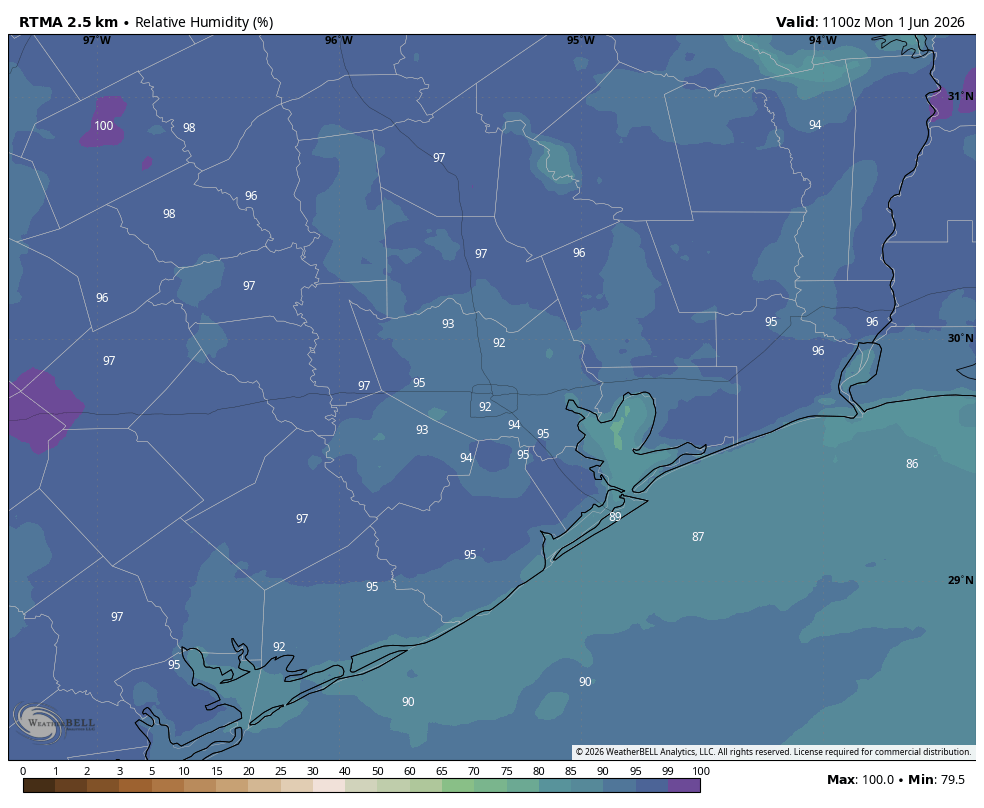
In brief: In today’s post we have our “please clap” announcement about the beginning of summer. It’s here, and we might as well do our best to survive it. Fortunately we’re not starting off summer this year blistering hot. Also not, we will have higher rain chances during the second half of the week.
Relativity humidity this morning is well above 90 percent across the region because, June! (Weather Bell)
Welcome to summer
June 1 marks the beginning of meteorological summer, encompassing the three months of June, July, and August. As we noted last week, summer in Houston typically runs from mid-May through mid-October, and fortunately this year we are not off to a particularly simmering start. For now it appears like we’ll remain in the “Early summer” phase at least through the middle of this month, so that’s pretty good.
Today also marks the official beginning of the Atlantic hurricane season. As usual, the topics to start June this year are pretty quiet, with no points of concern. We’ll be back later today with a post about everything you need to know for the upcoming Atlantic hurricane season, so be on the lookout for that.
Monday
Today will likely produce the lowest rain chances of the week. That’s because the high pressure that brought sunny skies over the weekend will retain some impact into this week, and it will be most influential today. Any showers are likely to be brief, and isolated. We can expect partly sunny skies, with highs around 90 degrees in Houston, a touch higher inland and a touch cooler closer to the coast. Humidity will be sky high. Winds remain light, generally from the southeast. Lows tonight will drop into the upper 70s for most locations.
Tuesday and Wednesday
Rain chances each of these two days will push into 30 to 50 percent chance, with partly sunny skies and highs around 90 degrees. Any showers that do form should pass fairly quickly, so I’m not expecting anything too meaningful in terms of accumulations. Lows at night remain warm and fairly sultry.
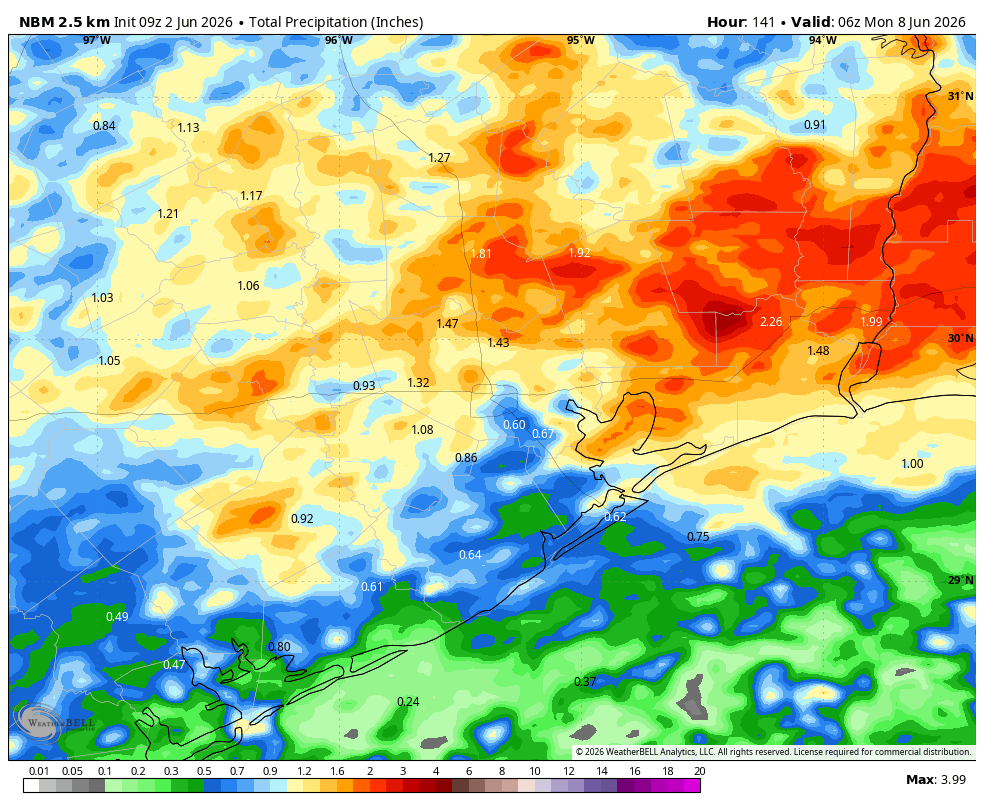
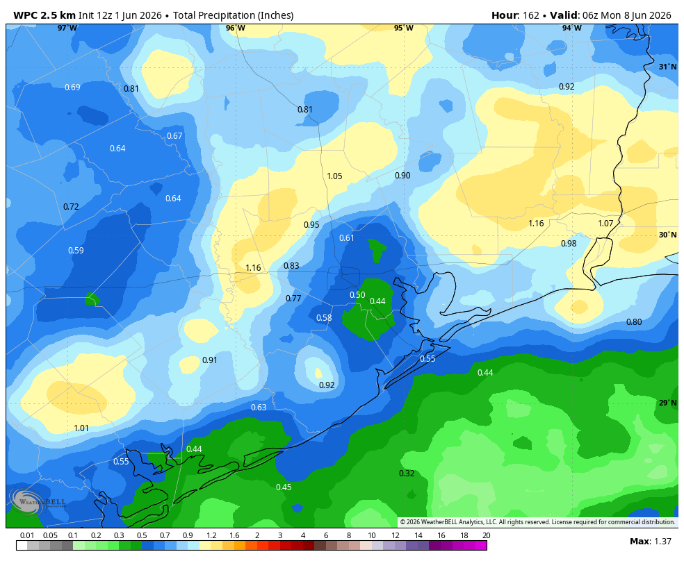
NOAA rain accumulation forecast for now through Sunday. (Weather Bell)
Thursday, Friday, Saturday, and Sunday
I’m putting these four days together because the forecast picture is fairly muddied. As high pressure moves off the atmosphere will open up to the potential for more substantial disturbances, and therefore more widespread rainfall. But storms will not be wall to wall, and each day will likely have some sunshine in addition to rain chances in the vicinity of 50 or 60 percent.
So for the second half of the week we can expect partly sunny days, with highs in the upper 80s, and the potential for showers often during the afternoon. If you have outdoor plans bear in mind there may be problems, but at this point the forecast is far from certain. I think overall rain accumulations will vary widely through the weekend, but most areas can probably expect between 0.5 inch and 1.5 inch total.
Next week
I think we’ll see a little more sunshine next week, with overall rain chances declining somehwat, but not going away entirely. So basically, it will still feel a fair bit like June.