In brief: The rest of this week will see the potential for storms in the Houston region, and as of right now Wednesday looks to have the most widespread activity. Due to the possibility of heavy rainfall within stronger thunderstorms, and the cumulative effect of multiple rounds of rainfall, we have put a Stage 1 flood alert in place for this week.
Unsettled pattern
As we’ve been discussing on the site, Houston remains in a pattern where the absence of high pressure leaves us open to passing atmospheric disturbances. We will continue to see these systems sweep through our region every 18 to 24 hours or so, bringing a chance of widespread showers and thunderstorms. Not everyone is going to get hit with storms every day, but the threat of heavy rainfall and lightning is going to be part of our weather story at least through the weekend.
We can count on daily rain chances of 50 percent, or higher, through Sunday. Due to the potential for isolated flooding with each round of of showers, and the cumulative effect of all this by the weekend, we have put a Stage 1 flood alert into place until further notice. This is to cover the potential for (mostly minor) street flooding issues.
Tuesday
The radar is quiet this morning, and I expect things to likely remain quiet until around noon. However, after that there is about a 50 percent chance of showers and thunderstorms, with perhaps the best chances in the central Houston area and to the far north of the metro region: i.e. Conroe and points north. Skies will otherwise be partly sunny with highs in the low- to mid-90s. Actual highs will depend on the timing and coverage of the rainfall. Winds will generally be light, except in thunderstorms. Lows tonight will be in the upper 70s with a slight chance of rain.
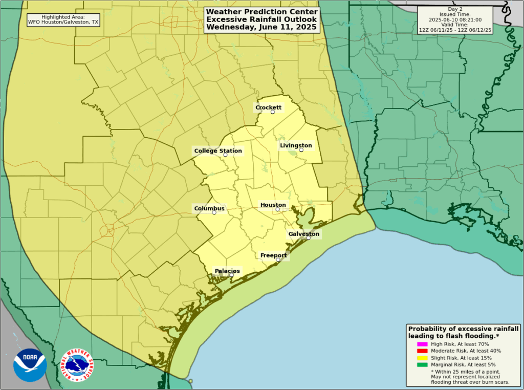
There is a slight chance of “excessive rainfall” on Wednesday in our region. (NOAA)
Wednesday
High resolution models are indicating that a particularly potent disturbance will sweep through on Wednesday. I’d put rain chances in the 70 or 80 percent ballpark, with a slight risk for excessive rainfall. The timing is tricky, but right now the most impactful rains and thunderstorms are likely to fall during the middle of the day. Highs will probably top out in the vicinity of 90 degrees.
Thursday, Friday, Saturday, and Sunday
Overall the pattern is not likely to change much over the second half of the week, and into the weekend. Days will be partly cloudy, with highs in the vicinity of 90 to 93 degrees, with plenty of humidity. Each day will bring perhaps a 50 to 70 percent chance of rain, with isolated, strong thunderstorms. If you have outdoor plans, there’s a chance you can squeeze them in, as it certainly will not be wall-to-wall rain. But you probably want to have a backup plan.
Next week
This overall pattern now seems likely to extend into the middle of next week, perhaps through about Tuesday or Wednesday, before we see more sunshine and warmer temperatures, along with a diminution in rain chances.

Your forecasts are always measured which I appreciate. Is it me though or are they becoming less certain on timing and severity than they used to be? Are there fewer data points in our area than before?
A lot of the activity we’re seeing is influenced more heavily on the mesoscale, less on the synoptic scale. The ability to discern and forecast with reliability on a longer scale of time is a bit more diminished due to this. Even the HIRES models can have problems in the short term.
It does seem like now, every time there are storms there is a higher probability that they will be severe in some way. I’m getting tired of having to worry about it every time it happens, but it is what it is.
That comes with the territory of a warming planet. More heat and humidity intensifies the instability at the surface, which can spark severe storms more easily, given the appropriate upper atmospheric conditions.
Oh honey just look at the radar. There’s a stationary front draped over Austin to Lufkin, and a large area of rain from Austin to Waco heading this way. You can’t get any better precision than that. The data…it’s there for everyone to see!
Exactly. A picture is worth a 1000 words!
It’s such a relief to be getting this rain. Every week we can stay out of drought conditions is a blessing.
Keep it coming.
Summer Hater, Blackhawks fan, this is your time. Enjoy it.
Except it feels extra disgusting when the sun comes out after the rain.
Sweet, sweet soaking rain without extreme winds. I’ll do my best to soak it in as well. My Citrus and peppers are happy.
Thanks for all that you do! Since we are now in official hurricane season, can we expect weekly tropical updates on Tuesdays as in years past?
@N M … check SCW’s Atlantic hurricane site, The EyeWall.
Or (I think I’m getting with the razorback) why ask here, I ask you. The NHC puts out a daily map. They say today: “Tropical cyclone activity is not expected in the next 7 days” for the Atlantic. Just bookmark it on your smartphone. You’ll know the latest even if it’s just a tropical wave.
@DJ … we check the NHC “7 day Graphical Outlook” webpage daily. If I got this correct, it’s updated three times a day (?), morning, night, and somewhere in-between. (timestamp is at lower left of map).
Genuine question, and this may be me not paying attention. But Hail seems so much more likely these days than it used to? It seems like every storm pops up with Hail opportunity and after 1″ hail in The Woodlands yesterday, I can believe the possibilities.
Article at foxweather dot com: Texas slammed by deadly storms producing 100-mph wind gusts, grapefruit-sized hail.
… to quote:
Hail was also an issue, and there was a report of 4.25-inch hail in Claude, Texas. That’s nearly as large as grapefruit.
There were also several reports of hail between 2.5 and 2.75 inches across portions of central and North Texas.
It is likely because of 2 reasons. Due to the warming Earth, there is alot more water vapor in the air thanks to higher evaporation rates from the Gulf.
Land temperatures are also warmer than average most days as well. This increases the intensity of the updrafts needed for hail producing thunderstorms. The higher amounts of moisture in the atmosphere likely creates more hail stones given the appropriate conditions.
See Hungo Tonga underwater volcano for water vapor produced. Yet somehow, it’s never mentioned here…..weird.
It got its own dedicated post.
https://spacecityweather.com/what-was-the-hunga-tonga-eruption-and-is-it-causing-our-extreme-summer-heat/
I’ve mentioned it a few times. Even climate scientists admit that this volcanic eruption has contributed a little to the warming around the world.
Re the subject of hail. I’ve been experimenting with RadarScope. Just got it this year. One reader suggested looking at the “cloud top”feature so I did. That is bonzo! Hail is formed when rapidly rising storm cells hit freezing air high up. Cloud top shows you how high it’s going. The app also gives reflectivity data – hail is above 60 dBZ I think. If you’re going to live here a while you’d better pick up some tools. I learned the hard way after last year’s 2 big misses. Springtime is always surprise weather. Once the tropical ridge takes over in July, we’re doomed to broil so I love this weather.
PS if Apple ever gets their AI wit together all the info I need will just be a Siri question away. Instead of myriad apps and bookmarks. For those who want to know more than “do I need an umbrella?” anyway.
A wet June would be great. The last couple of summers have been rough.
Last July was actually not too bad, minus Hurricane Beryl. It was frequently rainy and cloudy where I live. But August was another story.