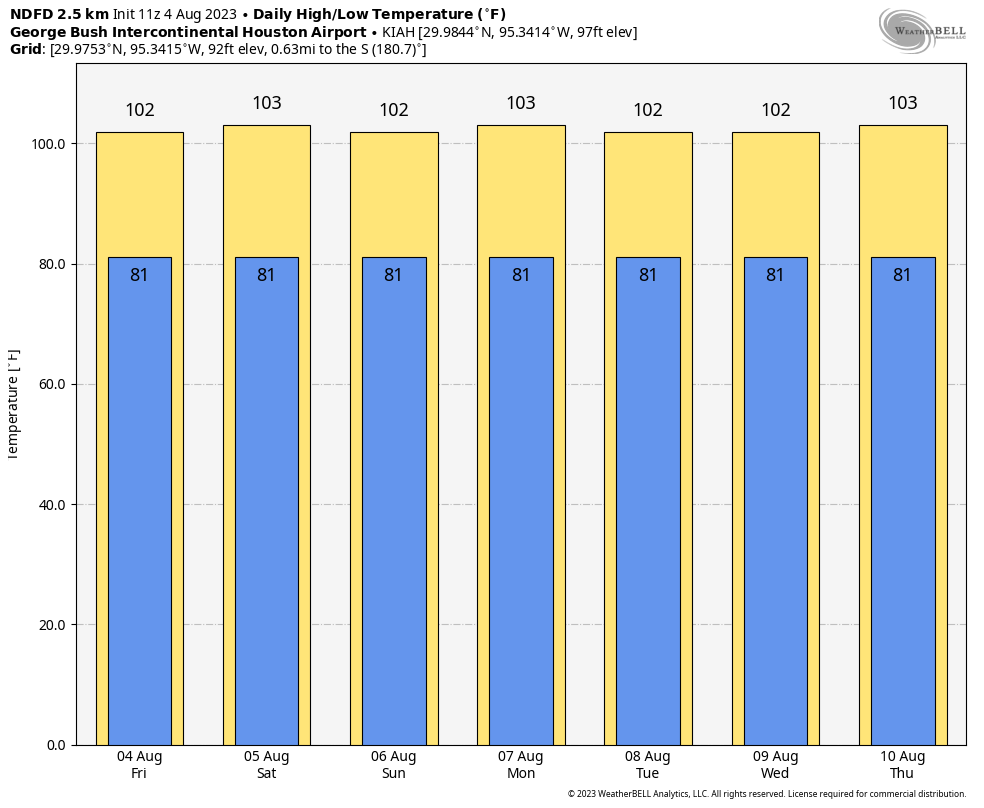
Good morning. I hope you had a wonderful weekend. While I would love to say that this is the week that Houston’s heat finally breaks, I cannot. We are actually amidst the climatologically warmest part of the year in Houston. From the period of July 29 through August 12, the average high peaks at 96 degrees, and the average low at 76 degrees.
However, after this week, we really will start to slowly slide toward fall. That is largely driven by shorter days and the Sun rising lower in the sky. Houston’s day length is already nearly 40 minutes shorter than it was at the peak of summer, and the Sun lower in the sky. By the end of this month, the day will be an hour and 17 minutes shorter, and instead of the Sun reaching a zenith of 84 degrees at midday, it will max out at 69 degrees. So fall is coming, if slowly.
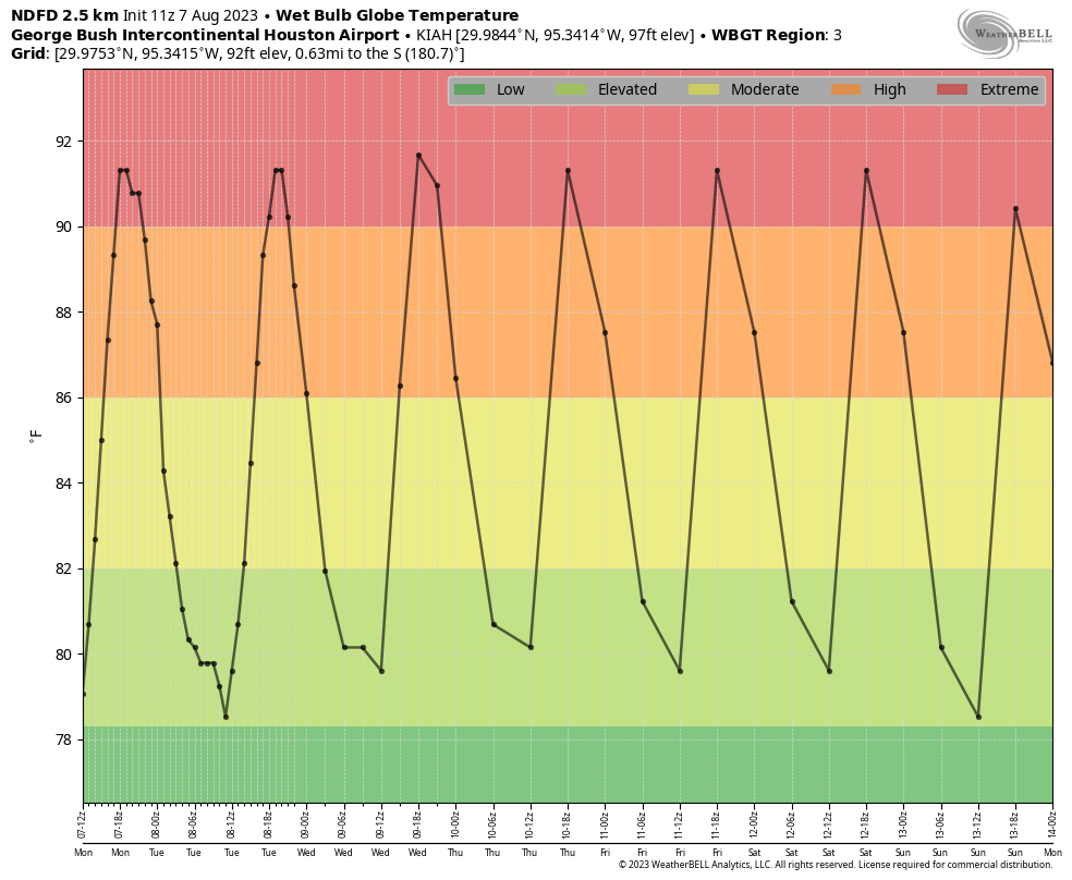
But not this week. High pressure will more or less hold sway, and there’s not much else to say. Highs will be around 100 degrees each day, and if we consult the wet bulb globe temperature forecast, which factors in humidity, winds, and other variables, we can see that daily heat will reach extreme levels. Sorry, it’s going to be pretty miserable. Please practice heat safety.
Anything of 90 degrees represents extreme heat. (Weather Bell)
Monday
High temperatures today will reach 100 degrees, or above, for pretty much the entire metro area. Skies will be mostly sunny. Rain chances are less than 10 percent, and winds will blow at just 5 to 10 mph. Lows tonight will only drop to around 80 degrees.
Tuesday through Friday
Our forecast is the same—bleak, barren, and hot.
Saturday and Sunday
If you were looking for a major pattern change by this weekend, unfortunately, I don’t see it happening. Forecast highs will be on the order of 100 degrees, or hotter for inland areas, with mostly sunny skies.
NOAA rainfall accumulation forecast for now through Sunday. Yeah, not great. (Weather Bell)
Next week
But what about next week? Is there hope? Careful readers will recall Matt writing on Friday that the heat may relax a bit by the second half of August. Global models do start to trend temperatures down a bit in seven to nine days from now, but only slightly. Rain chances also look to be on the upswing. However, these trends are far from definitive. I’m hopeful that this will be the last really, really hot week. But I’m not ready to firmly predict that yet.
I want to start my Friday post on a positive note. For weeks it feels like, Eric or myself have been writing these posts saying “we honestly don’t know when this excessive heat is going to meaningfully end.” We all know it will still be hot; it’s August after all, but it would be nice to tone it down just a little and maybe bring some rain back into the picture.
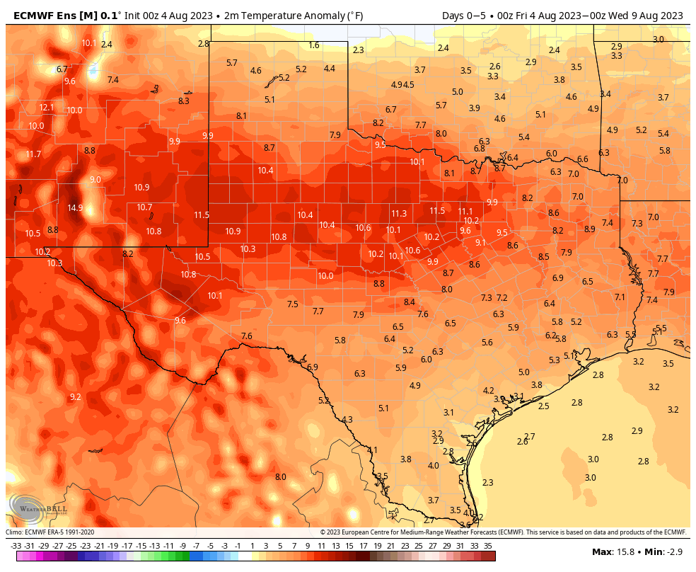
Temperatures over the next 5 days are certainly going to be a good deal above average, even for August across all of Texas. (Weather Bell)
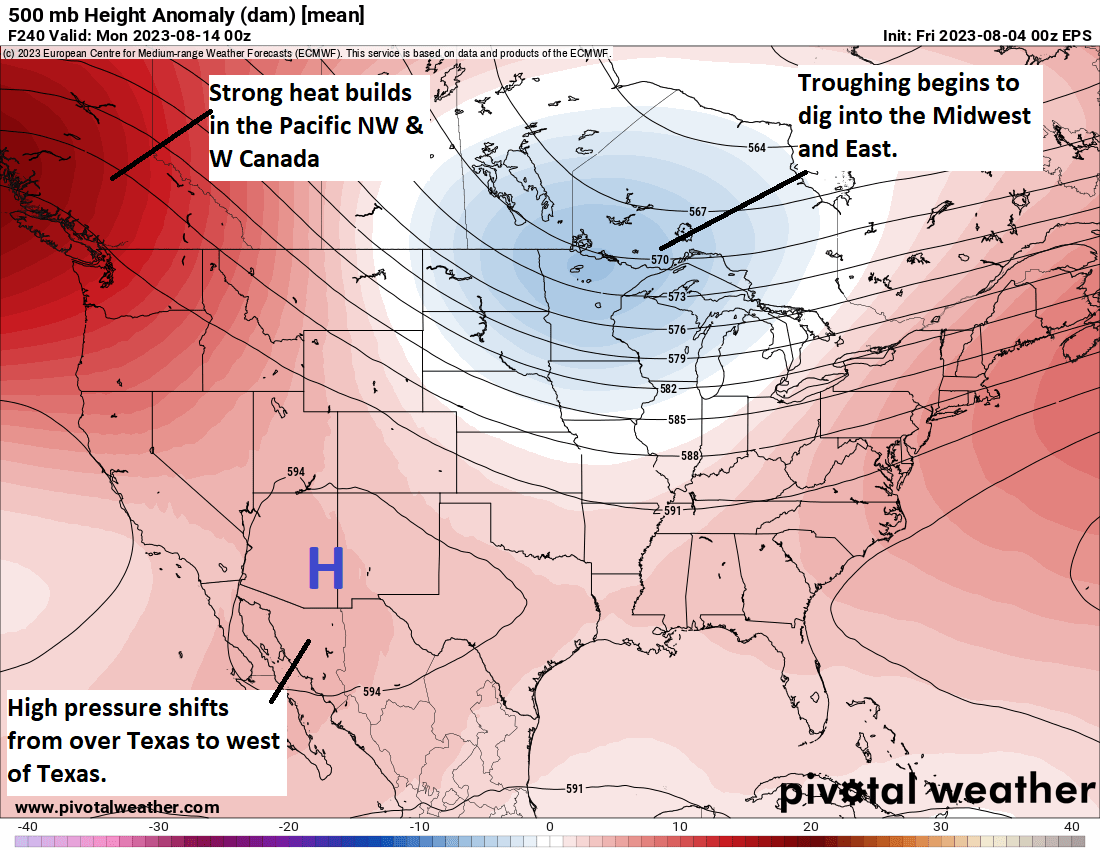
Eric has alluded to some potential change at the end of posts the last day or two, and I think we’re starting to build some legitimate momentum for this to occur. As we move beyond days 7 to 10, we begin to see a bit of a shift in the pattern showing up in modeling. High pressure in the Southwest & Texas shifts just a little more to the west. Heat is established now in the northwestern corner of the country and parts of Canada.
Some changes evolve late and beyond day 10, which include big heat in the Pacific Northwest and western Canada, a cooler trough digging into the eastern half of the country, and high pressure just drifting a little to the west from Texas into Arizona and New Mexico. (Pivotal Weather)
What this may do is help carve out a trough in the eastern half of the U.S. This is helpful for us in Texas because if this happens, it sort of puts us in the middle. Meaning, yes, it will still be fairly hot here, but not at record levels (think upper-90s instead of low-100s). It would also probably allow for the door to the Gulf to swing back open again and bring back at least some rain chances.
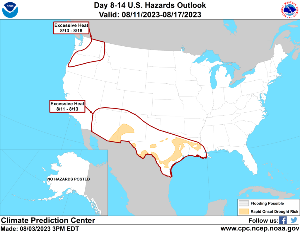
This is good news because drought continues to gradually worsen in Texas. The Climate Prediction Center hazards map for August 11-17 shows that many areas in Texas are at risk for “rapid onset drought.”
The Climate Prediction Center has noted continued excessive heat risk for Texas on August 11-13, but they also have highlighted much of East & South Texas for being at risk for “rapid onset drought.” (NOAA CPC)
What exactly are they talking about? Essentially “flash drought,” which is what happened in the Central Plains in 2012. Drought quickly goes from kind of bad to very bad very fast. This can have implications on agriculture, water supply, lake levels, etc. We really don’t want to be dealing with a flash drought here, but given the recent issues with wildfire flare-ups, as Eric noted yesterday, we may already be descending that path.
This is why we are really, really hoping that what we see beyond day 10 can hold. Fingers crossed.
Today and the weekend
Meanwhile, yes, it’s more of the same. More heat. More advisories or excessive heat warnings. More humidity. Drink more water and try to limit outdoor exposure when possible. Please also check on your neighbors. There have been a couple instances of showers popping up in recent days in central part of the Houston area. That could happen again today or tomorrow, but consider yourself extremely lucky if it does.
Summer to date, we’ve just tied 2009 for the 3rd hottest on record in Houston. We are only a couple tenths of a degree behind 2011 for 2nd hottest, and over the next 7 to 10 days, we’re likely to go neck and neck with that summer. I suspect 2011 will pull away in the end, assuming our pattern does change some later in the month.
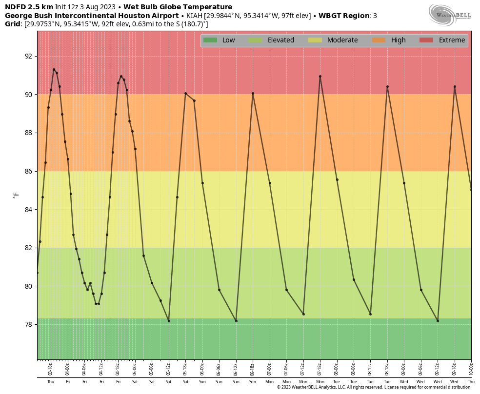
“Hey Siri, show me what stability looks like in a weather forecast.” (Weather Bell)
Next week
Copy and paste. More heat and more sun. Look for a slight rain chance Tuesday afternoon and then maybe again by Friday. Any changes that take place in the weather pattern would not materialize before next weekend. So buckle in.
Hi everyone. We have reached early August, and if the past is anything to go by, our region has another six to eight weeks of really hot temperatures this summer. Certainly, the near-term forecast shows nothing but relentless heat.
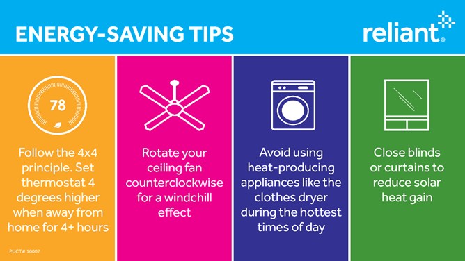
One of the major downsides of excessive heat is the need to cool our homes continuously, day and night. This can lead to higher-than-normal usage, resulting in higher electricity bills. As you may know, Reliant is the long-time sponsor of Space City Weather, and today I wanted to share a conversation I had with them about things you can do to take a little bit of the sting out of your bill. So here are my questions, and their responses.
Why am I using so much electricity?
Many factors contribute to higher-than-normal electricity usage — most notably right now, the outside temperature. The hotter it is outside, the harder your air conditioner works to keep you cool inside. HVAC systems can account for up to 60 percent of your home’s electricity consumption in the summer, which is why we can experience seasonal bill spikes. You can learn about the top factors affecting your electricity usage and calculate the impact those have on your summer electricity costs here.
What are some strategies to manage my electric usage during the hottest months?
We all know this summer has been hotter than normal, but we still have a lot of summer left with temperatures typically reaching their peak in August. While we can’t control the outside temperature, we can find ways to stay comfortable AND in control of our electricity usage. The tips below will help you stay cool while conserving energy, ultimately helping you save money.
Follow the 4-by-4 rule: If no one is going to be home for more than 4 hours, adjust the temperature 4 degrees higher while you’re gone.
Use ceiling fans rotating counterclockwise to help circulate cool air, which can help you feel 4 to 6 degrees cooler.
Use blinds or curtains to reduce solar heat gain by up to 50 percent. Blackout curtains are especially helpful in keeping rooms cool by blocking direct sunlight.
Avoid using appliances that generate heat during the hottest part of the day. Plan to wash or dry clothes and use your dishwasher in the early morning or late evening hours when it’s cooler outside. Wait to use the dishwasher until you have a full load.
Get regular tune-ups for your HVAC system to ensure it’s running at its best, including checking and replacing air filters regularly. In the summer, this can be as often as once a month.
Stay informed about your usage. Using the Reliant app, you can track usage, control your Google Nest thermostat, pay your bill and set up automated text and email alerts on the go.
How has the Texas electricity grid been holding up this summer?
Texas has been experiencing record heat this summer, and ERCOT has broken numerous peak load records. However, the grid has been performing well. Additional details are available on ERCOT’s website.
Why have there been calls for conservation on some days?
Demand response is an important tool for both retail electricity providers, like Reliant, and ERCOT to manage supply when extreme summer heat creates high demand across Texas. At times, electricity providers might proactively ask customers to conserve for a short period to help manage supply and costs, or ERCOT can issue a statewide call for conservation to balance overall supply and demand.
Reliant also has a program that rewards customers for adjusting their thermostat and reducing energy usage called Degrees of Difference. Read more in this post from SCW.
Is there help available for those who need it?
Yes! Reliant has 22 Beat the Heat centers across Houston that are free and open to the public, providing a comfortable place for the community to stay cool and safe, while decreasing energy usage at home. Reliant partners with the Houston Health Department and Precinct 2 to beat the heat together. For more details on locations and hours, visit reliant.com/beattheheat.
What happens if I am having trouble paying my bill?
No one should put their health at risk by choosing to not run their AC when the weather gets this hot because they are afraid of a higher-than-normal bill. From payment extensions to average monthly billing, we have options available. Reliant’s CARE program also helps customers who are facing financial hardship. Reliant has committed $1 million in funding this year and more than $17 million in statewide agency assistance since 2002. Anyone who needs help paying their electricity bill this summer can also call 2-1-1 within Texas or visit 211texas.org.
Anything else to add?
We hope the rest of this summer will be uneventful but rest assured, Reliant and Space City Weather will be there for you. If you’re a Reliant customer and need assistance, please reach out to us directly. We’re available 24/7 via live phone support at 1-866-222-7100, online chat, or on the Reliant app. We also want to thank Eric and Matt for their commitment to keeping us informed, no matter what the weather brings. Stay cool, SCW readers!
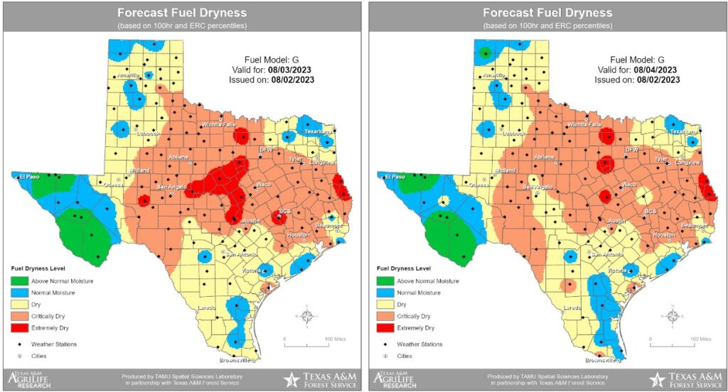
Good morning. One byproduct of the heat and lack of rain this summer has been increasingly dry grasslands, and accordingly we’ve started to see the outbreak of wildfires. For example, on Wednesday, the Texas A&M Forest Service worked hard to contain the 215-acre “Snowhill Fire” in San Jacinto county, to the north of the Houston area. Fire conditions will persist for at least the next several days with the ongoing heat and could be exacerbated by winds a little bit higher than the region has has seen of late.
The model output below from the Forest Service highlights areas where fuel on the ground, particularly grasses, is susceptible to burning.
Fire threat for Thursday and Friday. (Texas A&M Forest Service).
Thursday
As for the weather forecast, well, do you need to ask? High pressure continues to dominate our weather and we will see highs of around 100 degrees today with perhaps a 10 percent chance of rain. Skies will be mostly sunny, with lows near 80 degrees. Winds will be light, generally from the southeast, at 5 to 10 mph. Basically, this is unchanged from what we’ve been experiencing.
Friday
More of the same.
This weekend: Still very hot, but maybe not extremely so. (Weather Bell)
Saturday and Sunday
As high pressure starts to slowly slide westward, temperatures may come down slightly this weekend. We’re talking highs in the upper 90s to 100 degrees for most of the area, instead of highs around 100 degrees. So, probably not noticeable. Rain chances both days are on the order of 10 percent with mostly sunny skies.
Next week
The forecast for next week still calls for hot weather. But there’s still the potential for some slightly better rain chances by Wednesday or so as high pressure weakens a bit. The question is whether it will weaken enough, and I don’t think we can say that yet. Looking further into my crystal ball, I think there may be some hope for this overall pattern to change slightly, and for the better, by mid-August or so. But again, we’ll need at least a few more days before that’s something to feel confident in.