Good morning. Our overall pattern remains more or less the same, with high pressure leading to very hot weather for the next week, and quite possibly beyond. Today and Thursday could bring the worst of the weather, with very high dewpoints contributing to the heat.
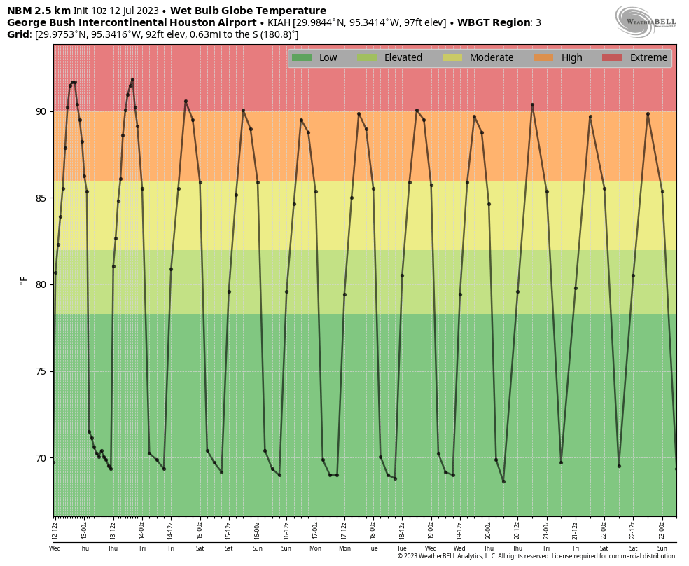
We see this in the forecast for “wet bulb globe temperatures,” which factor in several variables to provide an overall guidance for how uncomfortable conditions will be. (I discussed these a bit more in depth on Monday) Temperatures for today and Thursday are forecast to be above 90 degrees, which means our weather will be extremely uncomfortable.
An excessive heat warning is in effect for much of the metro area today. (National Weather Service)
Wednesday
There is not much to say beyond the fact that temperatures will reach about 100 degrees, with sunny skies and stifling humidity, and modest southwest winds at about 10 mph. Lows tonight will drop to around 80 degrees.
Thursday
Conditions will be much the same, although southerly winds may be a little higher, at 10 to 15 mph.
Friday
With the influx of slightly drier air and winds gusting up to 20 mph, conditions might be slightly more tolerable outside. But temperatures will still be really hot, about 100 degrees for much of the region away from the coast.
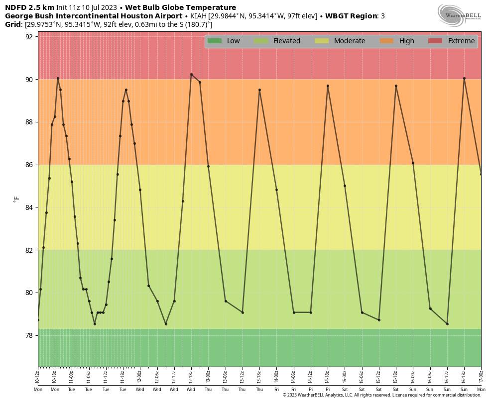
Wet Bulb Globe Temperatures may moderate slightly heading into the weekend. (Weather Bell).
Saturday and Sunday
Yes, the weekend looks sunny and hot.
Next week
A series of atmospheric disturbances will push through the area later on Sunday and on Monday; and were we not under the influence of high pressure, these are the kinds of systems that would bring us a healthy chance of rain. However, due to generally sinking air over the region, I’d rate the chance of these disturbances at producing rain at about 10 percent. Still, it’s something to watch, as most of the rest of the forecast just looks to be unendingly hot, humid, and rain free.
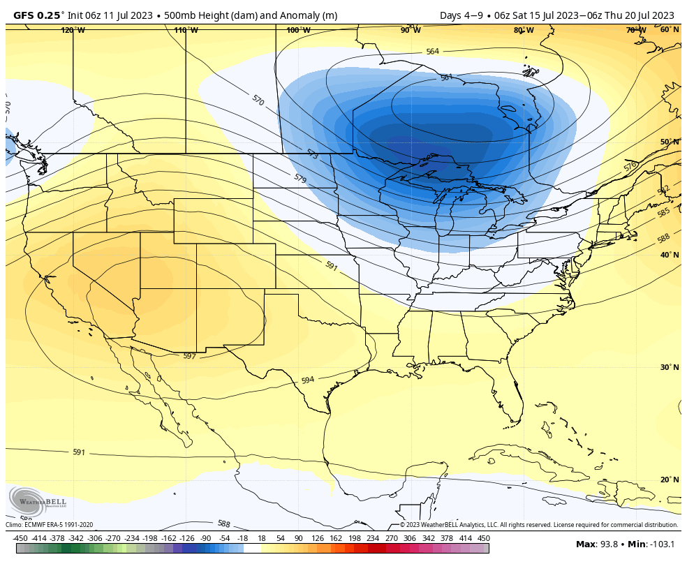
This is bad for business, but as usual we’re going to be honest with you here. For the next few days, at least, you really do not need to check the daily forecast here at Space City Weather. We are in a persistent pattern of high-pressure dominated weather that will last for at least the next week, and quite possibly longer. This high anchored over the southwestern United States, is not going anywhere, any time soon.
High pressure will remain anchored over the southwestern United States for awhile. (Weather Bell)
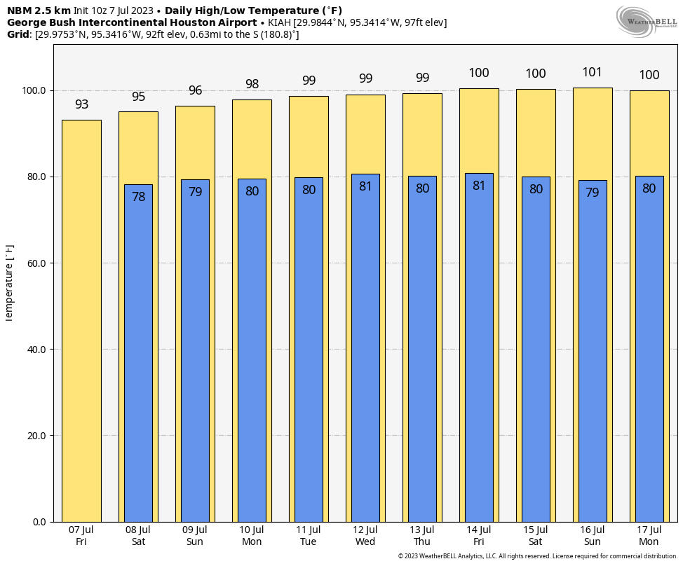
The conditions that we’re going to experience through the middle of July are not atypical, per se, for this month. It is summer in Houston. It is hot. But the heat is going to be tenacious, with daily temperatures 3 to 5 degrees above normal, and without any let up. Every day is going to see high temperatures in the upper 90s to 100 degrees. Lows will barely fall to 80 degrees. And while there is a very slight rain chance this afternoon, overall chances will be 10 percent or less on most days. The entire metro area is under a heat advisory and will remain so for the foreseeable future.
Tuesday
Skies will be mostly sunny with high temperatures near or reaching 100 degrees for most of the region away from the coast. Winds will be light, at 5 to 10 mph from the southwest. There is perhaps a 10 or 20 percent chances of showers and thunderstorms this afternoon, but most areas will not see anything resembling rainfall. Lows tonight will be around 80 degrees in Houston.
Wednesday
A similar day, albeit with even lower rain chances. Look for highs in the upper 90s.
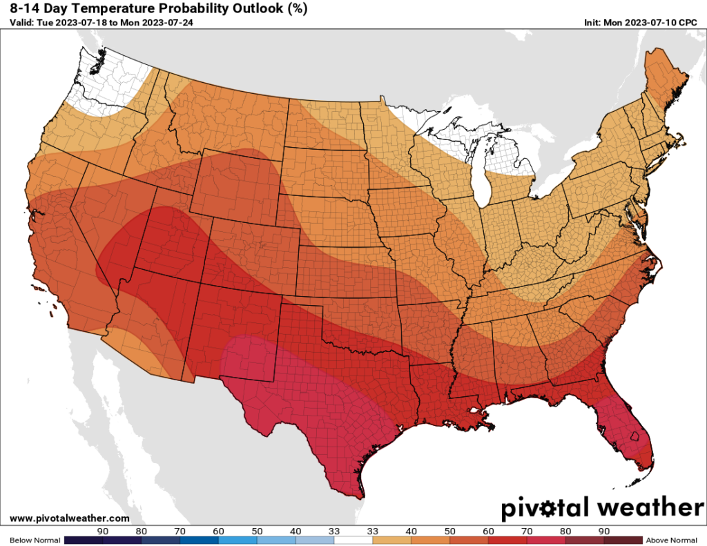
Above-normal temperatures are likely to persist through next week. (Pivotal Weather)
Thursday until ???
From Thursday, through the weekend, and at least into the middle of next week we are looking at hot and sunny weather, driven persistent high pressure. This means mostly sunny skies, highs near 100 degrees, and warm, humid nights. It is possible this pattern breaks somewhat by the middle or end of next week, but I would not hold my breath.
We talk about the heat index from time to time, and this characterizes the heat outside by factoring in both the temperature and relative humidity. This is also the basis for “feels like” temperatures on television broadcasts. But there is another, still more accurate measurement of heat stress if one must be out in the direct sunlight, and this is called the “Wet Bulb Globe Temperature.” It’s a bit of an odd name, but it takes a lot of factors into account, including temperature, humidity, wind speed, Sun angle and cloud cover. Chances are, if you’ve been in the military, you heard of the Wet Bulb Globe Temperature.
Recommendations for various levels of WetBulb Globe Temperatures.
The important thing to remember about these temperatures is that anything above 80 degrees requires precautions, and anything above 90 degrees is dangerous if you’re outside for a prolonged period of time. I say all of this because the Wet Bulb Globe Temperature is a good measurement to characterize the extremeness of the heat we’re going to see this week, and the bottom line is that it should not be quite as bad as what we experienced in June. Back then, daily Wet Bulb Globe Temperatures were consistently in the low 90s. This week we will be a few degrees below that. It will still be very warm, with a heat advisory in place for much of the region. But it won’t be quite as extreme.
Wet Bulb Globe Temperature forecast for this week. (Weather Bell)
Monday
That was a rather long introduction for what will be a short forecast as high pressure over West Texas influences our weather for this week and beyond. Expect mostly sunny skies today, with high temperatures in the upper 90s. There is perhaps a 10 to 15 percent chance of isolated showers and thunderstorms this afternoon. Light southwest winds of 5 to 10 mph will provide little relief. Low temperatures tonight will only drop to around 80 degrees.
Tuesday
A similar day, with slight rain chances and highs in the upper 90s.
Wednesday, Thursday, and Friday
Look for highs in the upper 90s to 100 degrees, sunny skies, and warm nights. Each day will be more or less the same as we bake.
NOAA’s rain accumulation forecast has an “abandon all hope ye who enter here” feel to it. (WeatherBell)
Saturday and Sunday
The temperature may increase slightly this weekend, as sunny skies prevail. Hot, hot, hot.
Next week
At this time I don’t foresee too much of a change heading into next week. There are some scenarios in which we start to see a decent chance of rain by around Tuesday or so of next week, but at this point it’s difficult for me to bet against persistent heat as high pressure reigns supreme. Rest assured, we’re looking for any signs of change.
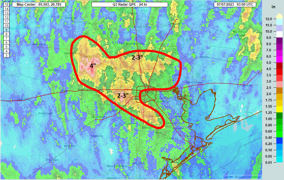
Yesterday saw some locally hefty rains across the area. We picked up anywhere from 1 to 4 inches of rainfall between Pearland and Westchase, with another bullseye out west of Cypress along 290 into Waller County.
Radar estimated rain totals were as high as 4 inches in parts of Waller County and close to that near the intersection of the Westpark and the Beltway. (NSSL)
Areas just south of The Woodlands saw 2 to 3 inches of rain as well. Even Matagorda Bay (not shown above) saw about an inch or more in most the area. We are not yet done with the rain, though we do not believe today will play out quite as yesterday did.
Today
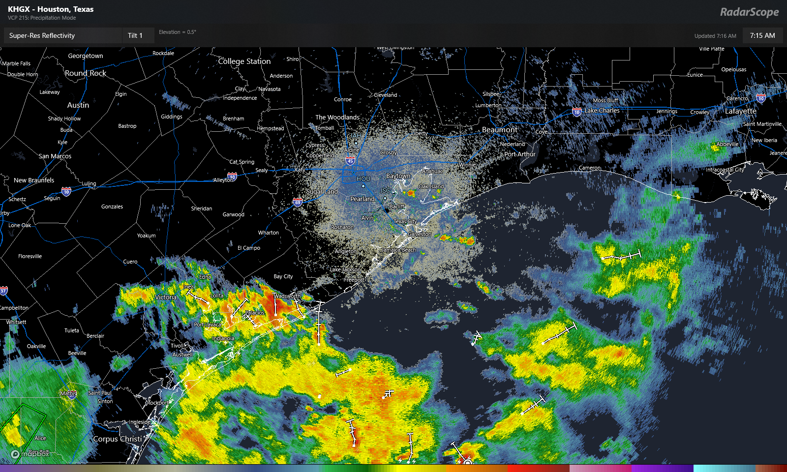
We’re starting the day off with an area of rain sitting near Matagorda Bay and just a few showers in and around Galveston Bay and the island.
Heavy rain is impacting the Matagorda Bay area this morning, with just a few showers and rumbles of thunder around Galveston Bay. (RadarScope)
As the day goes on, look for more scattered thunderstorms to develop across the area. The highest chances will be south and east of about Cypress. So much of the area will see showers or at least hear thunder again. Those that see showers today could see as much as an inch or two of rain, while others will see next to nothing. Look for generally low 90s and light winds (except localized gusts in storms).
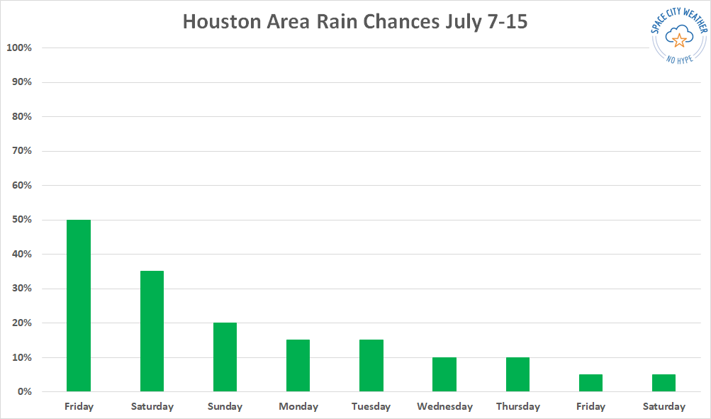
It feels like we have one or two more decent chances at rain today and tomorrow before the spigot is basically shut off.
Saturday & Sunday
If you have weekend plans, you will probably be fine. But there will certainly be thunderstorms in the area. Look for about a 30 to 40 percent chance of showers and storms on Saturday, followed up by about a 20 percent chance on Sunday. Outside of showers, look for sun, clouds, and slowly increasing temperatures. We’ll be in the low to mid-90s tomorrow and firm mid-90s on Sunday. Morning lows should be in the 70s on Saturday before back closer to 80 degrees on Sunday morning.
Early next week
Rain chances don’t quite go to zero to start next week, but they will drop off to the 10 to 20 percent range on Monday and Tuesday. As that occurs, look for temperatures to warm into mid to upper-90s, with morning lows near 80 degrees. It will begin to feel rather uncomfortable with peak heat index values over 105 degrees.
We expect to start seeing the question “when will this round of heat ease up?” soon, and unfortunately we don’t have a clear answer right now. (Weather Bell)
Heat returns
By the time we get to Wednesday, look for high temperatures near 100 degrees, give or take a couple, with morning lows around 80 degrees. The difference between this heat wave and June’s heat wave will be noteworthy. In June, the high pressure setup directly over northern Mexico or Texas, and we just baked with extreme (for June) heat. This time around, it looks more like a traditional summer heat wave, with high pressure centered over the Desert Southwest. It will strengthen and expand to a point where we see just a lot of generically “hot for July” weather in southeast Texas but probably not extreme heat. If the June pattern had recycled this time around, we’d probably be talking 102 to 105 degrees every day. Instead, we’re probably talking 98 to 102 degrees, which while quite uncomfortable is not terribly uncommon in July.
That said, I fully expect heat advisories to re-enter the chat by early next week. As this will again be a potent, long-duration period of high heat and humidity, heat precautions should be taken as they were in June.