Since there’s not a whole lot new to discuss today, I spent a little time looking at statistics from Hobby Airport last night. So far this June, the airport has registered a heat index of 110° or hotter for 18 hours. That may not sound like much, but consider that no other year in the 2000s has come close to this many hours of extreme heat in Houston, at least at Hobby. Not even the infamous 2011 summer. The most recent challenge to this year is in 1998, when we managed 32 hours of 110° or higher heat index values, almost all in July and August. 1997 saw 19 hours. 1982 saw about 22 hours. The infamous summer of 1980 had a heat index of 110° or higher for 16 hours in June and then another 14 hours in July. We will see if the coming weeks will have us challenge 1980 and 1998 for supremacy, but regardless, it’s just dang hot.
Today through Friday
Surprise! It’s going to be hot. High temperatures will be near 100 and lows will be near 80 degrees through the end of the week. For today, we have a heat advisory in effect, not an excessive heat warning — for now. That may change through the day. But at least it signals the chance that it may feel just a tiny, miniscule, itty bitty, small bit less oppressive. Either way, we encourage maximum heat precautions today through Friday with continued persistent heat and humidity.
The song remains the same. (Weather Bell)
For those curious, rain chances the rest of this week remain at roughly zero point zero percent.
Weekend
We’ll maintain persistence through Saturday, with more hot and dry weather. Sunday should, should mark the beginning of the transition out of this pattern. Rain chances may increase to a whopping 5 or 10 percent Sunday, but more importantly, the upper air pattern will finally start to break down, signaling changes next week.
Heat break next week
There is good news and bad news beyond the weekend. The good news is that the heat should reduce to more average levels for early July next week. For those that have forgotten, that means highs in the low to mid 90s each day, lows in the upper-70s, and heat index values in the slightly less extreme 100 to 105° range.
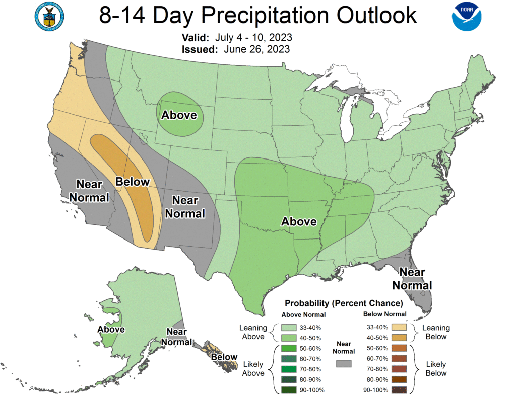
The rainfall forecast for next week shows slightly elevated confidence that it will be above normal. (NOAA)
Additionally, it means rain chances return to the area. Yes, this could mean a chance of showers or storms on Monday and Tuesday afternoons for the holiday, but it should at least mean some relief. We’ll hone in on specifics later this week.
The bad news? There are signs in our modeling that the heat over Texas may try to make a comeback after next week. But that’s still a long way off.
Once again, it will be important for all of us to practice maximum heat safety this week. Whatever index you use, it will feel terribly hot all week, with heat index values of 110 to 115 degrees and wet bulb globe temperatures in the “extreme” level for the human body. While the forecast temperatures will not be overly impressive, the combo of temperature and humidity remains abnormally potent for our area, the next level of heat.
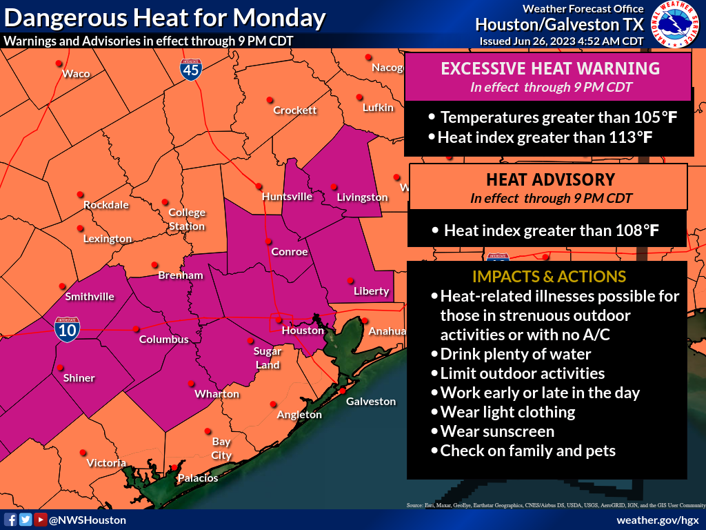
Yet another Excessive Heat Warning has been posted for Houston today. (NOAA)
Today through Thursday
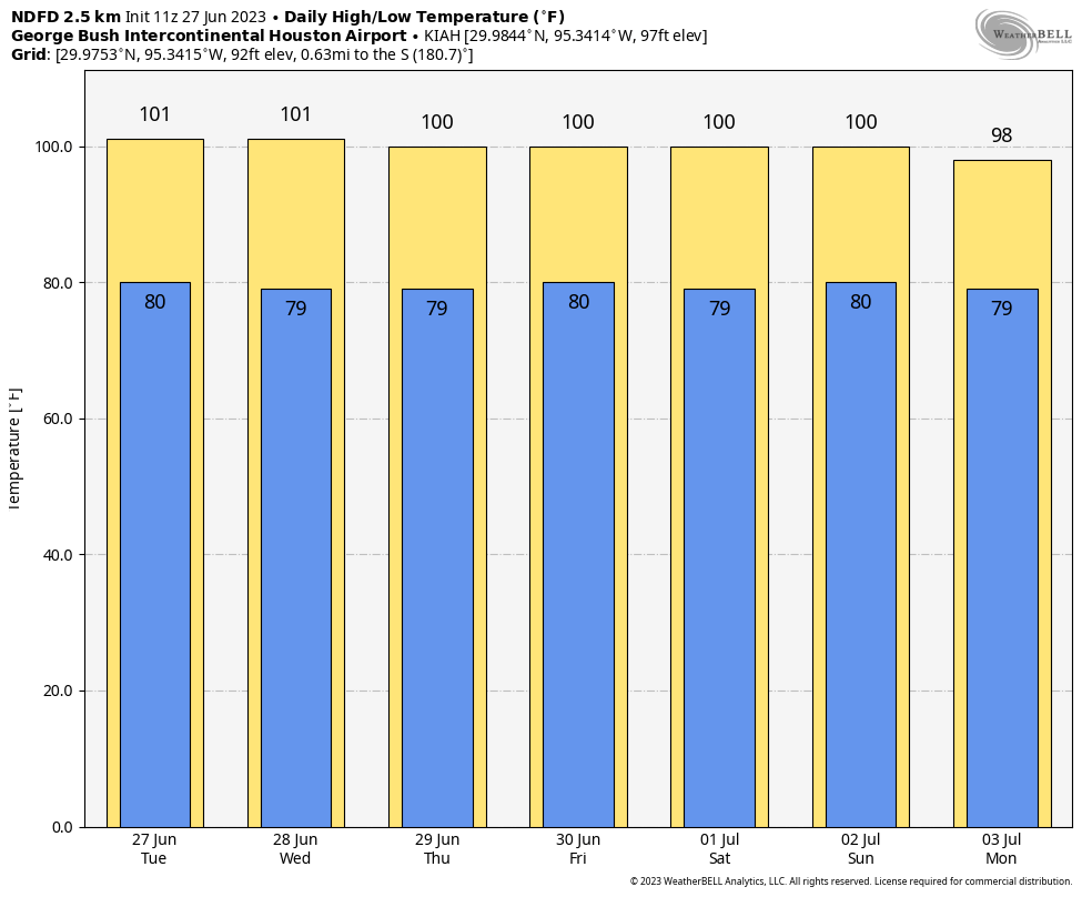
High temperatures will scorch the next few days, generally in the 100 to 102 range. Overnight lows will be near 80. Humidity levels will be awful. Rain chances look to be near zero through Thursday. Yada yada yada.
<very Mattress Mack voice> Extreme, extreme, extreme! Peak heat is forecast to be at or into “extreme” range all week. (Weather Bell)
Friday and Saturday
More of the same. I just wanted to break up the post a little.
Sunday and early next week: Relief?
So to the question you’re all wondering: When does this end? It appears more likely that by Sunday or Monday, the potent, relentless ridge over Texas and/or Mexico will finally break down. You can follow this on an upper level forecast map. Notice how you can clearly see the “dome” of high pressure over Texas. That finally begins to collapse on Sunday and Monday of the weekend/next week, and that should hopefully yield cooler temperatures and rain chances. Unless you have Fourth of July plans, in which case, of course.
By the time we get to Sunday or Monday, the high pressure system over Texas is expected to collapse — for now. This loop runs from today through next Tuesday morning. (Pivotal Weather)
But, we really need a period of cooler weather and hopefully some rain chances. We certainly hope the holiday is rain-free, but we’ll see.
Tropics
Nothing new or exciting to discuss. We’ve seen some noise on the operational modeling way out in fantasyland, much like we did earlier this month. But there is no real support for anything. Check our companion site, The Eyewall for a full tropical update for the Atlantic if you’re interested in more! And just a reminder, if a storm were to be a concern for Houston, we would still include all the relevant info here at Space City Weather. We’d love for you to read The Eyewall regularly, but you won’t be missing Houston-relevant info!
Hello on a Sunday, not because the forecast has changed (it’s going to be extremely hot the next 5 to 6 days, with excessive heat warnings in place again), but because I think folks deserve an explanation about this month. Our forecasts have not necessarily been horrible or anything, but we have all been caught by surprise at the ferocity of some of the storms in June. Many of you have lost power at one point or another, some for days, while others have sustained property damage from winds or hail. So, why?
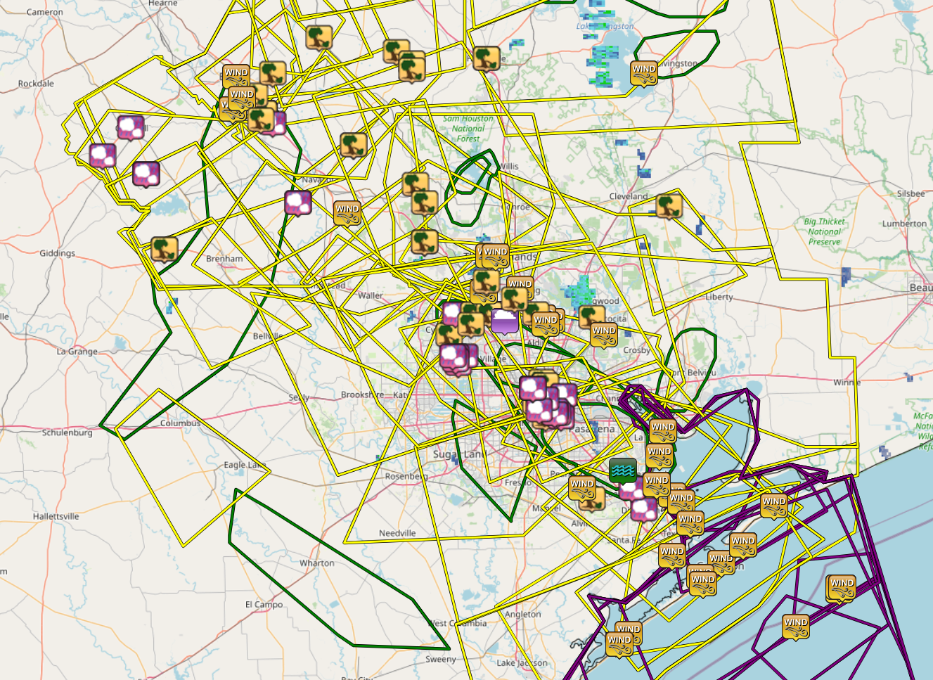
The National Weather Service forecast office in Houston has issued 47 severe thunderstorm warnings this month across the region. There have been a total of 159 wind or hail reports from across the region.
A map showing all of the warnings and storm reports from the National Weather Service Houston office for the month of June in the Houston area. (Iowa State Mesonet, IEM)
The actual number of damage reports is certainly much higher, as some were surely consolidated or others were not submitted to the NWS office. Whatever the case, it’s been a lot. The only portions of our area mostly spared some element of significant severe weather have been in Fort Bend and Wharton Counties through Lake Jackson and Matagorda Bay.
Let’s quickly recap a few of these events.
June 4th
We were delivered an early wake up call back on June 4th, when storms rolled through the metro area between Midnight and 2 AM or so.
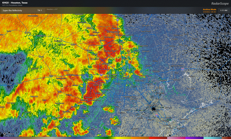
Thunderstorms oozed through Houston early on Sunday morning, June 4th with wind gusts as strong as 60 to 70 mph. (RadarScope)
Bush Airport reported a 62 mph wind gusts with these storms, and there were numerous reports of trees and powerlines down. These storms were not expected to hit so hard or quite so soon, so this one caught us a little off-guard. The 3rd was a relatively pleasant day with comfortable dewpoints and highs in the mid-90s (which sounds wonderful given where we are today). But with a weak upper low over Texas, that’s all we really needed to generate storms, and they just managed to survive the trip. Upper lows are notoriously fickle, and as such, we got burned.
June 8th
Wind and hail ripped across the area on the evening of June 8th. This event was better telegraphed than some others this month. We mentioned a good chance for storms and underscored the uncertainty around the storm evolution. So this one didn’t catch us off-guard. But it still ended up pretty vigorous.
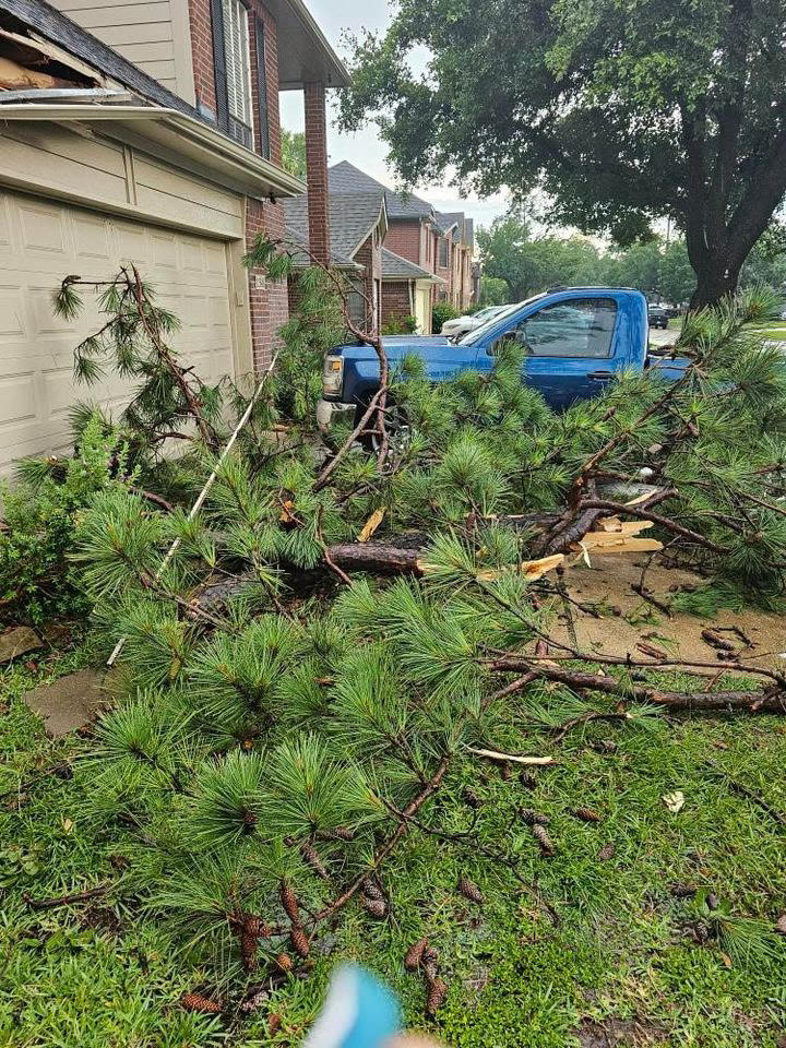
Wind damage near Cy Creek High School from June 8th storms (@addicted_to_reeses on Instagram)
Both IAH and Hobby gusted to around 45 mph with these storms, while just off of Texas City recorded a 67 mph gust. Centerpoint had something in the vicinity of 175,000 outages I believe. Hail reports were several, and rain totals of 2 to 3 inches southeast of Downtown Houston produced flash flooding.
June 10th
The storms on Saturday the 10th were also somewhat well telegraphed, as we were outlooked for severe weather and we noted the chance in our posts. The City of Houston was mostly fine in this one, but areas north and east and well northwest of the metro area saw some significant storm reports. Bush officially gusted to 58 mph, while Hobby hit 53 mph. Multiple 60 mph wind gusts occurred in the bays and off Galveston, while hail of golf ball size was reported in Burleson County.
June 21st
This past Wednesday’s storms were utterly ferocious.
Bush Airport’s 97 mph gust toppled Hurricane Ike from the top of the leaderboard there, with numerous other locations seeing 50 to 80 mph wind gusts, knocking out power to hundreds of thousands, some of whom remain in the dark as of this morning.
These storms were poorly forecast. We did talk up rain chances for Thursday, but in reality these came roaring in a good 12 hours faster than anticipated on Wednesday evening, and obviously with more rage than we predicted too. We can look to Friday for further evidence of this as well.
June 23rd
The latest round of violent storms struck on Friday evening with hail and wind. Hail to the size of golf balls and hen eggs fell south and east of downtown Houston and on the west side of the city in two pretty distinct belts.
Hail — and then the gust front from Lindale Park on Friday evening (@tokala on Instagram)
Some violent hail from some of these videos and also some strong wind too. We got a lot of reports from the Second and Fifth Wards, the East End, and Lindale Park. Hail reports continued into Downtown and just west into Montrose and the Heights but the hail became less frequent and smaller in size. Additional hail sprung back up as the storm moved west across the city, with large hail reported near SH-6 and north of I-10, from near Bear Creek and Copperfield into Jersey Village.
These storms also knocked out power to a bunch of additional folks, though wind was not the big issue here in most cases.
What happened this past week?
So, what exactly was at play this week, and why did we miss the mark on the forecast?
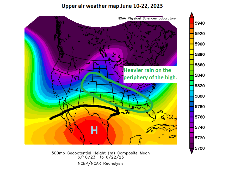
Often times in summer, high pressure tends to “anchor” in one part of the country or another. This month, we’ve seen it anchor mostly over South Texas and Mexico.
High pressure has been mostly anchored over Mexico and South Texas, while thunderstorms have been most active on the periphery from Colorado into the Southern Plains and into the Southeast. (NOAA)
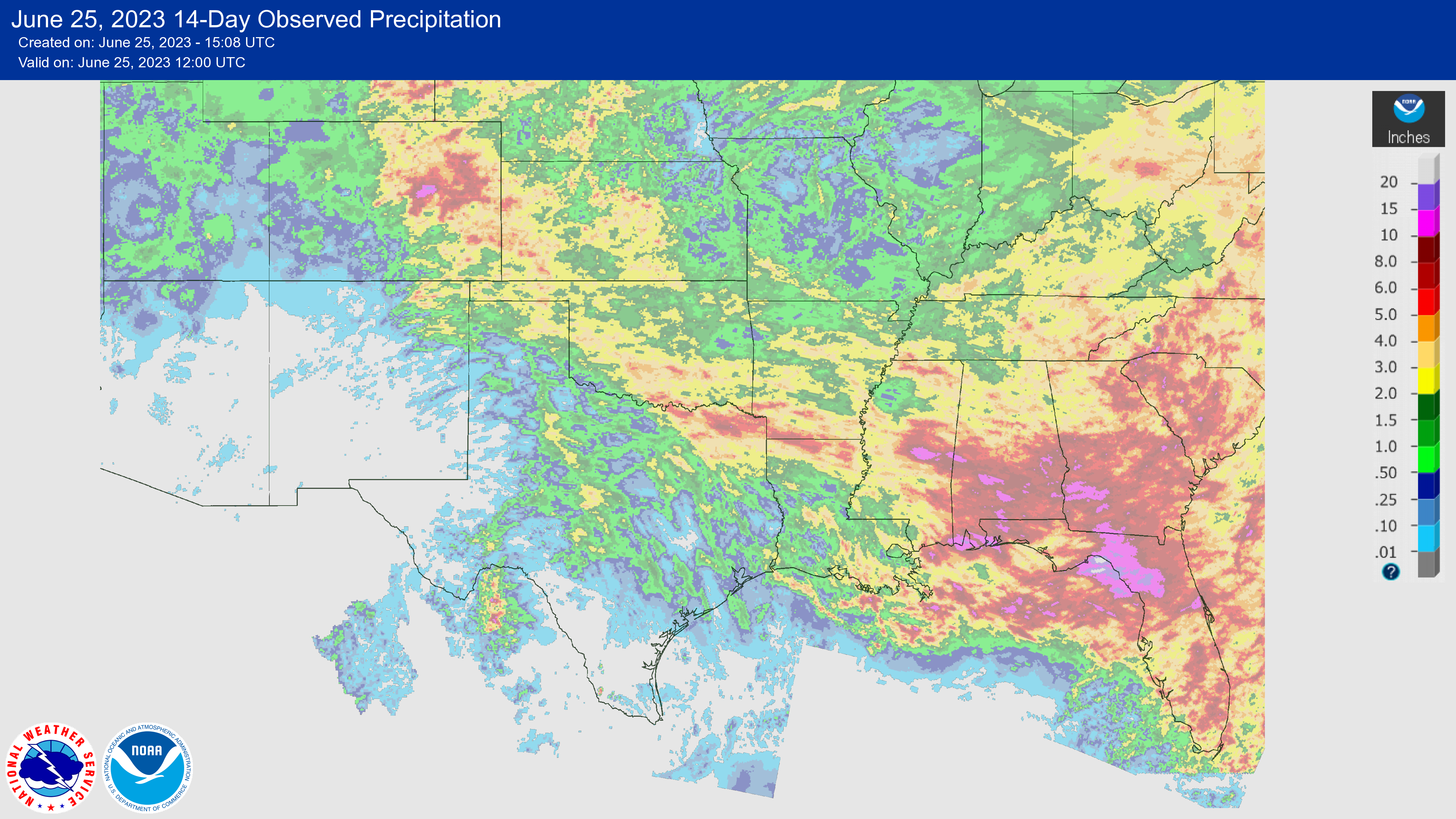
Storms have generally driven the periphery of the ridge, which has led to high precipitation over the last couple weeks from Colorado into the southern Plains and Southeast.
Rain totals over the last couple weeks have been at their highest from Colorado into Oklahoma, northeast Texas and into the Southeast. (NOAA)
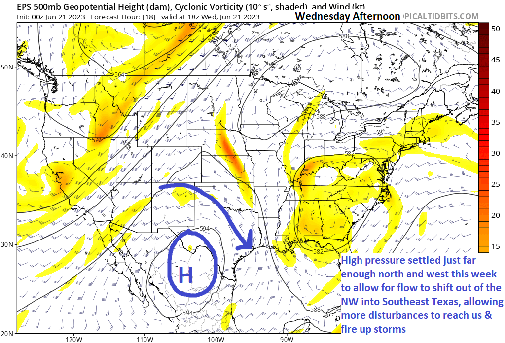
There were a couple changes this past week. The high reoriented closer to Big Bend (which allowed some all-time record temps to fall in South Texas), but it also shifted our flow to more northwesterly or northerly.
The upper level weather map from Wednesday afternoon showed high pressure over northern Mexico, allowing for northwest flow to slide disturbances into SE Texas. (Tropical Tidbits)
Why is this important? A couple reasons. Being along the periphery of the high allows for the best combination of daytime heating and instability, as well as being “in the way” of quick moving disturbances. The amount of instability that developed on Wednesday afternoon in particular was extremely high, some of the highest we usually get around here. We just needed a spark, and we got it. We thought the disturbance was targeting more like late Wednesday night or Thursday morning, which would have resulted in storms but perhaps not high-end severe storms. Instead, it coincided with peak instability on Wednesday evening, and alas we got walloped.
On Friday, we expected some storms to the east. That happened in the morning and afternoon. But with lingering boundaries and a little spark from a nearby upper disturbance, we were able to just keep building storms again and again as they migrated around the periphery of the developing high pressure over Texas — until it just ran into dry air and fizzled southeast of College Station.
So Wednesday’s storms were more driven by a strong disturbance coinciding with peak heating. Friday’s storms were more mesoscale in nature (smaller scale things like wind boundaries helped buoy them). Both events were enhanced by extreme levels of instability provided by heat and humidity. Wednesday’s storms brought significant wind because they were 60,000 feet in height and collapsed, bringing all the wind down with them. Friday’s storms brought more hail issues than wind issues because the storms were 60,000 feet in height and continually redeveloping. Updraft after updraft allowed for large hail to form. Different drivers and different reasons for the outcomes we experienced.
In general, predicting these types of storms is kind of a roll of the dice. Disturbances “ride the ridge” at different speeds, which are occasionally out of sync with your forecast. And localized effects can lead to more substantial outcomes. Unfortunately on Wednesday, the storm began collapsing just as it approached the densely populated northern half of the metro area. And on Friday, the storms peaked in height & intensity right over the city. We still struggle at times with these types of events, but we learn from them to hopefully help next time.
Hopefully this is a useful explanation! We’ll be back with you as normal Monday morning.
Through June 10th, Houston had experienced our coolest June since 2017, with a chance to perhaps outpace that year too. Since June 10th and through yesterday, it has been the third hottest mid-June stretch on record. When all is said and done, this will end up being one of our hottest Junes on record. We are firmly in it over the next week.
Today
I am not prepared to say that our rain chances are over with just yet. There are storms offshore of Louisiana this morning, along with a couple clusters of storms riding the periphery of the heat ridge over Texas.
Storm clusters riding the periphery of the heat ridge over Texas may lead to some showers and storms, mainly east of I-45 today. (College of DuPage)
As those clusters drop south and east, complex interactions with lingering boundaries from storms in recent days could yield at least a few new storms, mainly east of I-45. I think that’s the exception, not the rule and that the intensity of the storms will (hopefully) be much less than seen the other night. So don’t bank on storms. But just know there’s a chance.
Outside of that, more of the same: Clouds, sun, a heat advisory that could be upgraded to an excessive heat warning, and plentiful humidity. Highs will be in the upper-90s.
Saturday & Sunday
Hot. Highs near 100, lows near 80. Rain chances decline to near zero.
No relief is expected through next Thursday. (Weather Bell)
Next week
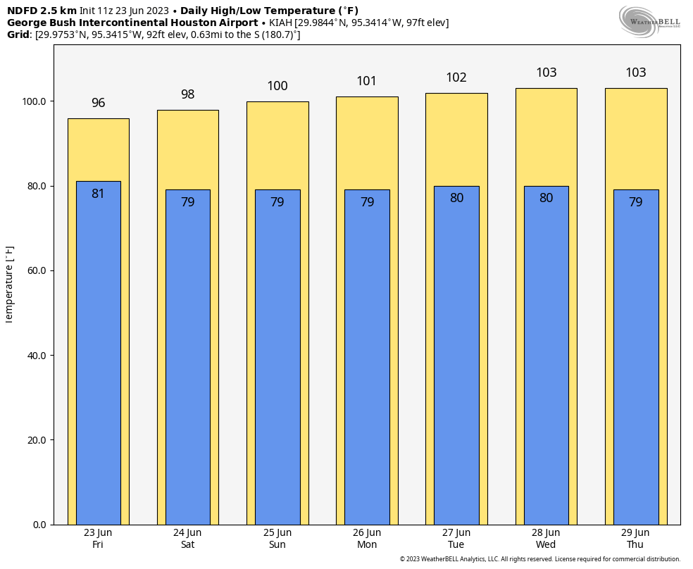
We will escalate the heat daily until about Wednesday or Thursday, when things should peak. This will push us into the low-100s for highs, with lows again near 80. While humidity doesn’t look *as* high as this past week’s heat, it will likely be high enough, along with slightly less wind to lead to another round of potential Excessive Heat Warnings.
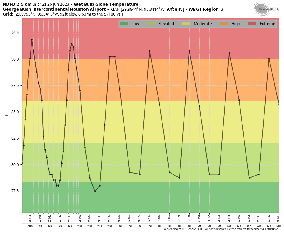
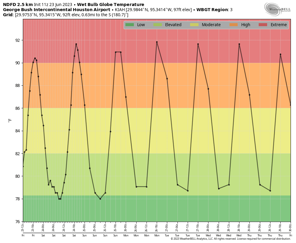
Wet bulb globe temperature is another measurement of heat stress on the body that we can use to assess the seriousness of a heat wave. In this case, it will be at “extreme” levels this weekend and next week (Weather Bell)
When we look at the wet bulb globe temperature forecast for Houston we see extreme values continuing, much like this past week. Heat index basically factors in humidity and temperature to give us a “feels like” value in the shade. Wet bulb globe (WBGT) factors in things like latitude and date to generate sun angle, wind speed, and cloud cover, in addition to temperature and humidity to generate a measurement of heat stress in the sun. What I like about WBGT is that it’s sort of a universal measurement. Once above 90, that poses extreme stress on your body, whether in Houston, Miami, or Phoenix. Houston would typically be in the moderate to high level of WBGT this time of year, so the fact that we’re in “extreme” levels speaks to how abnormally hot this is for us.
A long way of saying: Take it easy on yourself. Go slow. Drink water. Maximum heat precautions need to be fully implemented over the next week.
Hopefully the “death ridge” responsible for this heat shifts into the Desert Southwest next weekend or the week of July 3rd. Should that happen, perhaps we can resume more typical summer weather here in Houston, which while still certainly hot, would be a little less stressful on our bodies.