Gusty southerly winds likely the norm through the weekend for Houston

Springtime winds have returned to Houston. On Tuesday the region recorded gusts above 35 mph, and it was at times unpleasant outside. As a reminder, April is the windiest month of the year in Houston, with an average wind speed of 8.9 mph. However this month has been windier than most. So far, the monthly average this month is 10.0 mph, and we will probably end up a little higher than that with gusty conditions ahead this week.

Wednesday

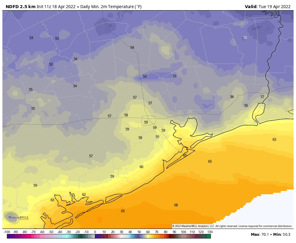
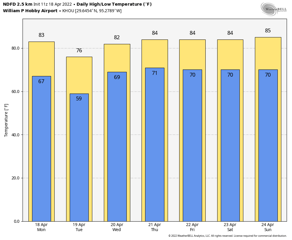
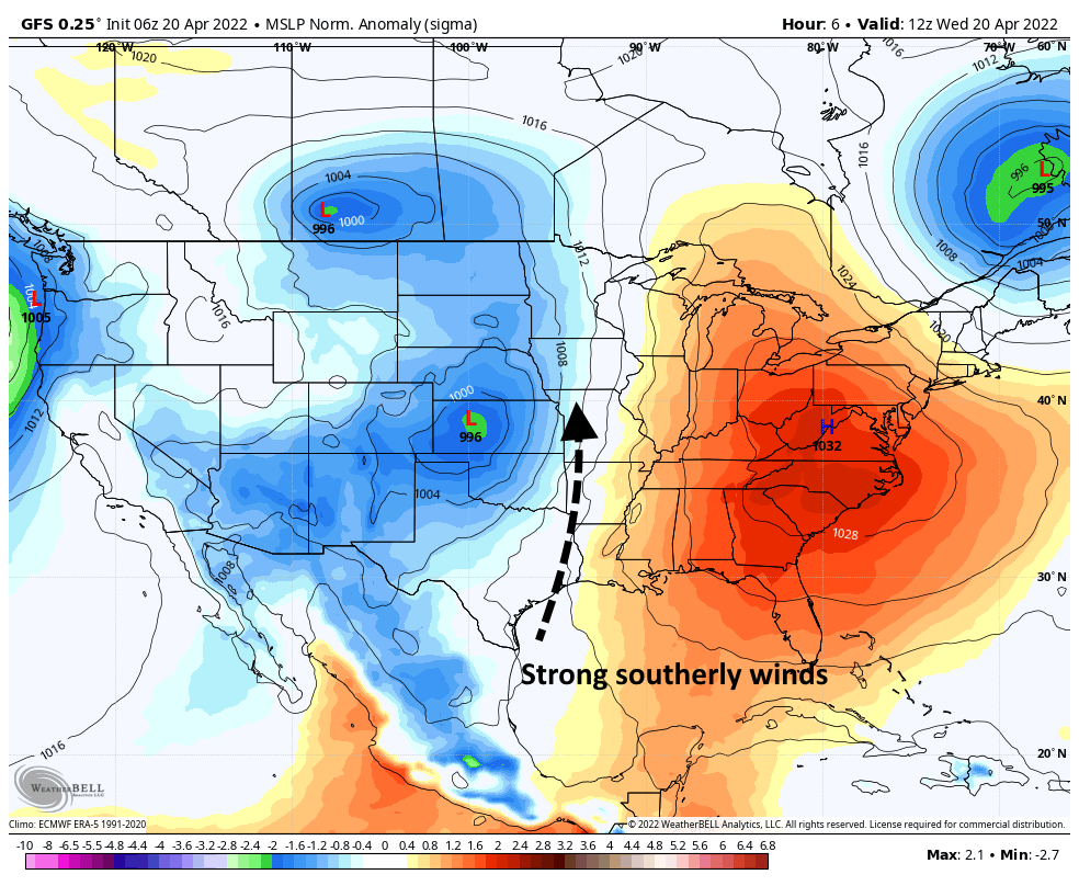
Low temperatures this morning have only fallen to around 70 degrees. Highs this afternoon will reach the low-80s, moderated in part by mostly cloudy skies. Strong southerly winds will again be the story, with gusts up to 30 mph or even a bit higher. The winds are being driven by a surface low pressure system over Kansas, the rotation of which is drawing winds northward. Low temperatures tonight will, again, likely only drop to around 70 degrees.

Low pressure near the surface of the Plains states will help drive southerly winds. (Weather Bell)

Thursday and Friday

The overall pattern will remain much the same, with highs in the 80s, partly sunny skies, breezy southerly winds, and plenty of humidity.

Saturday

The first half of the weekend should bring more of the same, but conditions might even be slightly windier. So yeah, while it should be sunny on Saturday, there will be plenty of wind to go along with it, with gusts of 25 to 35 mph possible.

By Sunday temperatures will be quite toasty for our region. (Weather Bell)

Sunday, Monday, and beyond

Sunday should be partly sunny and breezy as well, with highs likely in the upper 80s. But by Sunday night and into Monday we start to see some uncertainty creep into the forecast. Rain chances will increase on Sunday night and Monday, as a front nears. Right now chances appear to be better north of Houston. Then there is the question of how strong the front is, and how far it pushes through the region. For now I’m going with the front only having a fairly modest effect on temperatures and humidity, but we could see something stronger by Monday or Tuesday. Regardless, highs toward the end of next week probably will be near 90 degrees as we near the end of April.

After today, Houston’s weather will be on repeat for awhile

Good morning. Temperatures have dropped into the 50s across nearly the entire metro area this morning, which is fairly chilly for this time of year. But winds have turned easterly already, and that marks the beginning of warmer, windier weather for pretty much the rest of this week. We’ll be somewhere in the 80s, with lots of humidity and persistent southerly winds through the weekend.

Tuesday

Skies should be partly to mostly sunny today, and temperatures will remain on the moderate side with highs in the upper 70s. However, winds out of the southeast at 10 to 15 mph, with gusts of about 25 mph, and this will start to pump up humidity levels. Highs will reach the upper 70s this afternoon, but lows will only drop to around 70 degrees tonight.

Highs today will be pleasant, in the 70s, with a side of easterly winds. (Weather Bell)

Wednesday

In response to low pressure in the middle of the United States, winds will again be noticeable on Wednesday, out of the south at 10 to 20 mph, with gusts as high as 30 mph. Look for highs in the low 80s, with partly to mostly cloudy skies, and overnight lows in the low 70s.

Thursday and Friday

The end of the work week brings more of the same, albeit warmer, conditions. Look for partly sunny skies, highs in the mid- to upper-80s, with a breezy southerly flow. We’re not looking at anything extreme, but winds will be fairly constant this week.

Rain accumulation forecast for now through Sunday. Basically: It ain’t gonna rain. (Weather Bell)

Saturday and Sunday

More of the same: The weekend should see partly sunny skies, highs in the 80s, and more southerly winds. Despite increasing moisture levels, there is virtually no chance of rain through at least Saturday, and probably on Sunday as well.

Next week

Changes will eventually come to this pattern, but probably not until later on Monday or Tuesday, with the next front. All of this moisture will help setup our region’s next real chance of rain during that time frame, and then we should see some legitimately cooler and drier weather afterward. How wet and cool will it get? Alas those details are understandably fuzzy at more than a week out.

Reliant Giveaway winner

I’m happy to report that Mike Burgas and Laura Martinez have won the Reliant-Astros Giveaway! We’ll contact you shortly.

Play Ball! Astros home opener forecast, and a Reliant giveaway

The Houston Astros play their home opener for the 2022 Major League Baseball season this evening. Matt and I are both baseball fans, so we’re pretty excited. This year is even more special since our sponsor, Reliant, is now the Official Energy Provider for the Houston Astros. Thanks to Reliant, we’re giving away two great prize packages consisting of: two tickets to an upcoming game, a newly launched City Connect “Space City” jersey, and Reliant/Astros swag. First, let’s start with the weather.

Two mascots, one partnership. (Reliant)

Opening Day Weather

The Astros could not ask for better weather at game time, 7:10 pm CT, for their home opener with the Los Angeles Angels. Game time temperature will be in the mid-70s, with mostly clear skies, and moderate northeasterly winds. After the game the temperature likely will drop to the upper 60s. So basically, perfect weather for evening baseball. Enjoy!

Reliant powers Minute Maid Park and Astros Fans

As part of becoming the Astros’ Official Energy Provider, Reliant has a special electricity plan with some perks specifically for Astros fans, including a $100 Astros gift card that can be used toward tickets, team gear, concessions and more and an invitation to a unique Astros autograph session, plus, of course, a great electricity price locked in for the length of your term (more details here).

They have also installed 13 Reliant Charging Stations throughout Minute Maid Park, allowing fans to charge their phones on the go and without being tethered to one spot, which is new for the ballpark.

Giveaway

We’re also able to offer a special giveaway for Space City Weather readers. To win two tickets to the April 23 game, the new City Connect “Space City” jersey, and Reliant/Astros swag, please enter the giveaway we’re hosting on our Facebook page. Two winners will be chosen at random tomorrow (Tuesday) at 7 a.m. CT and announced here and on Facebook. We’ll then connect the winners with Reliant for all the details. Good luck and go Astros! 

After a brief flirtation with drier air, most of this week will be warmer and humid

Good morning. Houston will enjoy a brief return of dry air for the next couple of days before humidity settles in for the rest of the week. Overall, we’re heading into a quiet pattern, with no issues to speak of. Even tree pollen has finally started to settle down, after a long season.

Monday

A modest cool front has pushed through the area overnight, and the influx of drier air will lead to clearing skies this afternoon, with high temperatures likely slotting into the low 80s. Winds will be out of the north at 10 to 15 mph, with slightly higher gusts. We’re going to get one cool night with this front, and it will be Monday night, with temperatures dropping into the 50s for inland areas, with clear skies, and low 60s closer to the coast. This won’t be “cold” by any means, but such nights will be rarer and rarer as we get into late spring.

Low temperatures on Tuesday morning will be pleasantly chilly. (Weather Bell)

Tuesday

This will be a nice day. Look for highs to only reach the mid- to upper-70s. However, as winds turn easterly during the day time, at about 15 mph, we can expect to see the formation of some clouds and rising moisture levels. Lows Tuesday night will be back into the upper 60s already.

Wednesday, Thursday, Friday

The rest of the week should see partly sunny and warm days, with highs in the 80s and fairly strong southerly winds each day—perhaps about 15 mph with higher gusts. These will be humid days, with warm nights as temperatures only fall to around 70 degrees. Rain chances are near zero, however.

So yeah, that’s a pretty consistent forecast for Houston after Tuesday. (Weather Bell)

Saturday, Sunday and beyond

Right now the weekend looks to bring more of the same, with partly to mostly sunny skies, and highs in the mid- to upper-80s. Rain chances remain low, as well. At some point another modest cool front will probably make it to Houston, but that appears unlikely to happen before next Monday or Tuesday.