In brief: In today’s post we’re celebrating like it’s the 80s all over again, because that’s how February is going to end. In fact, with three days to go, this month already has had the third-warmest days on record in Houston. A weak front will bring somewhat drier air into Houston for the weekend.
Frying in February
On average, February is the third coolest month of the year in Houston. Put another way, of the winter months, it is the warmest; but still significantly cooler than the rest of the year. The normal high temperature for the month, based upon temperatures from 1990 to 2020, is 67.9 degrees. This year, our average high temperature with three days to go is 74.2 degrees. (Only 1962 at 74.4 degrees, and 2017 at 76.8 degrees rank higher).
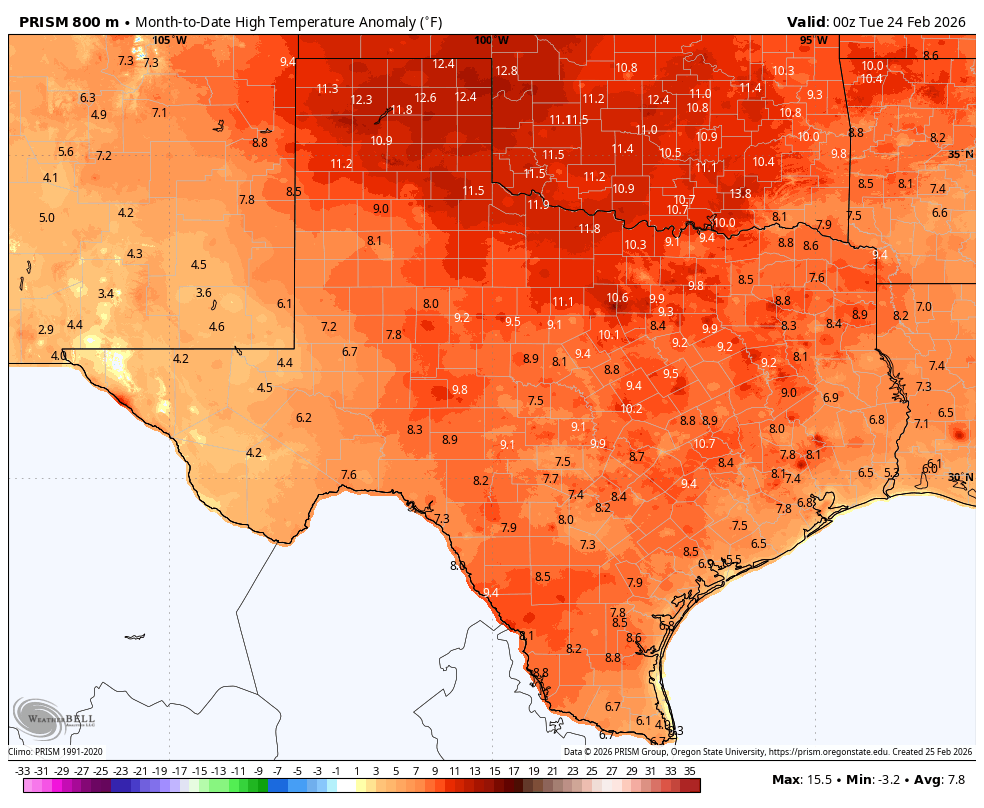
High temperature anomaly for February, to date, across Texas. (Weather Bell)
It’s not just been Houston. Persistent high pressure for much of this month has kept the entire state of Texas and our neighbors much warmer than average (see map above). Highs in the Panhandle and parts of Oklahoma have been especially hot, relative to normal temperatures this time of year. As we’ll report below, the heat party we’ve been dancing to this month will turn into a rave today as high temperatures soar as much as 20 degrees above normal. In fact we probably will end February with four straight days of highs of 80 degrees or above.
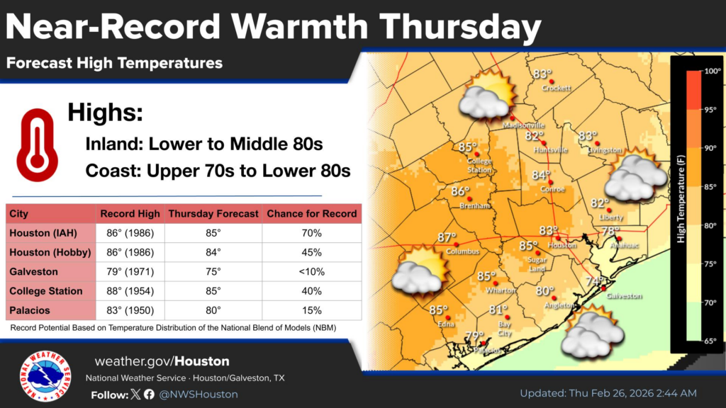
Thursday
Our winds have settled down some this morning, but they’re still a bit blowy from the southwest. We could see gusts up to 20 mph, but that will feel like nothing after widespread gusts of 40 mph on Wednesday. Because skies will be a little more cloudy today, I think that may shave 1 or 2 degrees off our previously forecast highs, and that could keep most of our locations at or below record high temperatures this afternoon. It’s still going to be warm, however, with highs in the low- to mid-80s for most locations except for the immediate coast. A weak front will arrive late tonight, but not in enough time to do much with lows, so expect them in the range of 65 degrees for most locations.
Friday
This will be a sunny day, and lower dewpoints should allow temperatures to push into the low- to mid-80s again. However, with the drier air it should feel somewhat less humid (the further inland you are, the less humid it will be), and low temperatures on Friday night should drop down to around 60 degrees. Note this is still pretty warm for this time of year, as the front just is not going to bring all that much oomph along with it in terms of colder air.
Saturday and Sunday
These should be partly to mostly sunny days, with high temperatures around 80 degrees. Yes, there will be some humidity, but no, it will be very far from oppressive by Houston standards. Saturday night should see temperatures drop down to near 60 degrees again, but Sunday night will be warmer. Saturday’s winds look moderate, but by Sunday afternoon we might see some southerly gusts up to around 20 mph.
Next week
Not much changes through at least the middle of next week. We’re going to see partly sunny days with highs in the vicinity of 80 degrees, and lows in the lower- to mid-60s. Some slight rain chances may return by the middle of the week, but we may have to wait until the weekend for a real uptick in the precipitation outlook. But this is far enough into the future that our forecast turns pretty fuzzy, pretty quickly.
In brief: Winds will really kick up on Wednesday as the onshore flow gets going, and this will lead to very warm conditions on Thursday. A weak front will bring us back to slightly milder conditions this weekend.
What’s with the alliteration?
Well, to be honest, I’m trying to add a little fun to what is otherwise a pretty boring forecast. We are going to see a spike in temperatures on Thursday, but for the most part our weather over the next 10 days is going to bring a lot of the same type of conditions: partly to mostly sunny days, highs in the vicinity of 80 degrees, lows in the low 60s, and medium-level humidity. I’m starting to have some hope for the eventual return of rainfall, but that is still more than a week from now, so I don’t want to offer anyone anything concrete yet on that front. Also, if you missed it on Monday, be sure and check out our monthly Q&A.
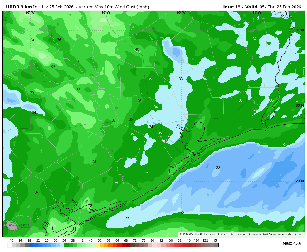
HRRR model forecast for maximum wind gusts on Wednesday. (Weather Bell)
Wednesday
Temperatures today will reach about 80 degrees, with mostly sunny skies. What will differentiate today is a potent onshore flow that will really start ripping by late morning. Most of the Houston area will likely see wind gusts up to 30 mph, but some locations could even briefly see 35 mph for a couple of hours this afternoon. Winds will start to slacken a bit this evening, and overnight lows probably will only drop into the mid-60s.
Thursday
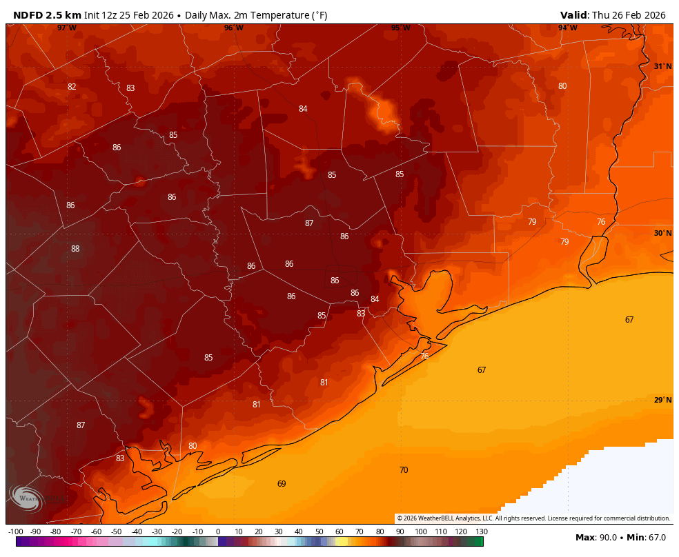
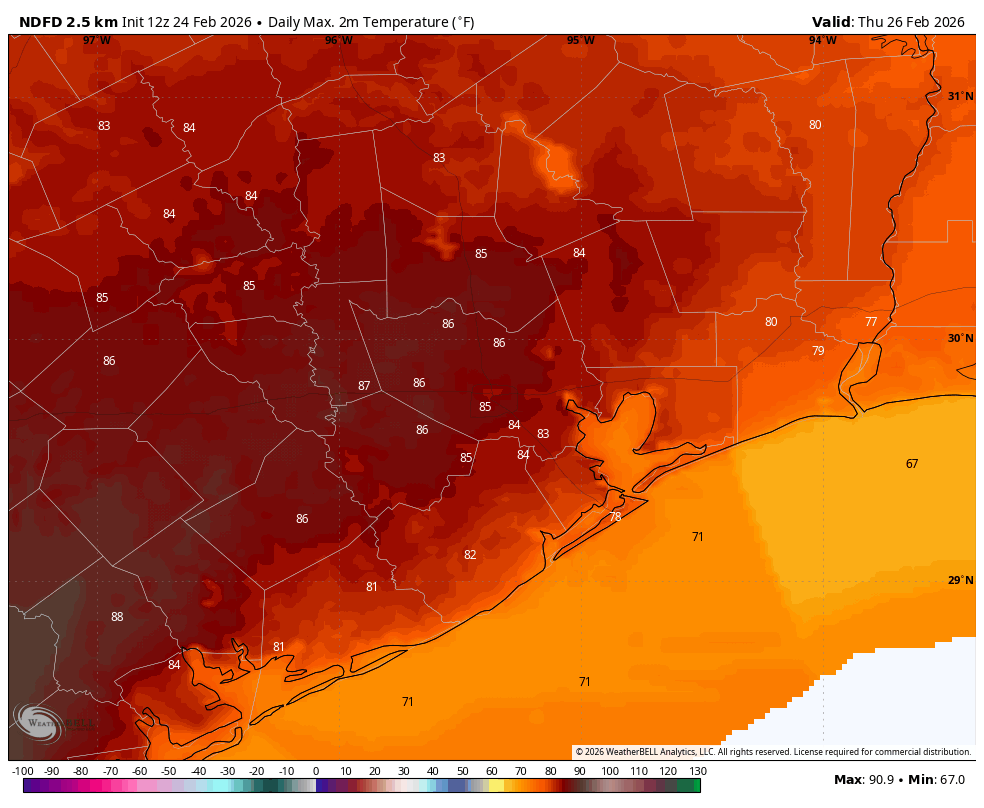
All of this warm air blowing in will make Thursday feel unseasonably hot outside. Temperatures should push into the mid-80s in Houston, with higher temperatures possible to the west of the city. Houston’s record high temperature for February 26 (set in 1986) is 86 degrees, and I think there’s probably a 50-50 chance that we beat that. Anyway, it will be close. Lows on Thursday night will only fall into the mid-60s for most locations, as a weak front won’t arrive until Friday morning.
High temperature forecast for Thursday. (Weather Bell)
Friday, Saturday, and Sunday
This front, which is likely to move into Houston and stall out, will be the driver of our weekend weather. It probably will be the case that if you’re in Tomball or The Woodlands you’re going to see longer stretches of drier air than, say, a League City or Alvin. I am not fully confident in how far the drier air will push, but overall I don’t expect Houston to feel too humid. Each day should have mostly sunny skies, with highs around 80 degrees (give or take) and lows near 60 degrees or a bit above. It won’t feel cold, but it also won’t be too hot and humid. In short, it will be one of those weekends where you can undertake almost any activity outdoors that you’re interested in.
Next week
This 80-60s weather likely continues at least into the middle of next week. What may change is that our environment becomes more favorable for rainfall by Wednesday or Thursday of next week. Whether this includes a frontal passage remains unclear.
In brief: After our cold start this morning, warmer weather will come roaring back today and Wednesday, which will be characterized by strong onshore flow. Thursday looks particularly warm, but conditions turn more pleasant this weekend.
Onshore flow returns in a big way
It is quite cold across the region this morning, with temperatures generally in the mid- to upper-30s across the region. The other thing to note is that winds are calm. That will start to change by mid morning as southerly winds start to pick up, bringing in warmer and more humid air in from the Gulf. By this afternoon we could see gusts up to 25 mph or higher, and the warming trend will be full on. Overnight lows tonight, as a result, will generally be 20 to 30 degrees warmer than Monday night.
By this afternoon wind gusts will reach about 25 mph from the south. (Ventusky)
Tuesday
For those of us up at this hour, it’s a beautiful and clear morning, with a lovely sunrise. Those clear skies will persist through the afternoon hours, and we are going to see high temperatures rise this afternoon to between 70 and 75 degrees. As noted above, winds will be gusty, from the south. As moisture levels in the atmosphere increase, we’ll see some clouds develop this evening and during the overnight hours.
Wednesday
If you liked the onshore flow on Tuesday, you’re in luck. It could be even more frisky on Wednesday, with gusts up to 30 mph from the south. Skies, otherwise, will be mostly sunny with high temperatures of around 80 degrees. Lows on Wednesday night will drop into the upper 60s, and it will feel modestly humid.
Thursday
This will be the warmest day of the week, with most of the area pushing into the mid-80s (possibly upper 80s for a few areas well inland) along with mostly sunny skies. Some parts of South Texas will be sizzling, and well into the 90s. A weak front will push through on Thursday night, allowing lows to drop to around 60 degrees for inland parts of Houston, with conditions a bit warmer near the coast.
Thursday’s forecast high temperatures. (Weather Bell)
Friday, Saturday, and Sunday
A generally wonderful weekend awaits us. Those strong winds we are going to see on Tuesday and Wednesday should be gone. Skies should be mostly sunny. And temperatures will be pleasant, with highs in the upper 70s to the low 80s, and lows in the 50s to around 60 degrees. Dewpoints won’t be super low, but they should be low enough such that it doesn’t feel particularly humid outside. In short, this should be a pretty spectacular weekend for any outdoor plans to have.
Next week
The forecast starts to turn fuzzy after Sunday. Another modest front could push through early next week, bringing a few nights in the 50s, or maybe it will stall before reaching Houston. Mostly we should remain in the vicinity of daytime highs around 80, and lows around 60. Unfortunately we probably are at least 10 days away from seeing any meaningful rainfall.
Time for yet another Q&A post, in which we answer your questions about area weather and Space City Weather itself. If you missed past Q&As, we keep an archive of them here. Submit your own questions via the Contact link on the blog’s home page, or post it to our Weather Talk topic on our Discourse forum.
Q. Every year for the past 20 odd years I’ve been raking leaves on my property in North Houston and this would normally stop by mid January. It’s mid February and maples and water oaks are shedding like crazy, not to mention that it seems like the drought made pines start dropping their needles like a month earlier. What is going on!?
A. First of all, I’ve noticed this phenomenon as well this winter, and have wondered the same thing. Second, I am not an arborist (although I do love trees). However, I do think the weather is involved here, and probably explains what has happened.
The only thing a pile of leaves is really good for.
Live oaks typically keep their leaves well into winter, as you note. Then, they finally drop their leaves just as new ones are ready to emerge. So why is it happening later this year?
I would go back to our very warm weather in December (especially the second half of the month), followed by similar conditions through the first three weeks of January. This led to a delayed drop. Then, I suspect the Arctic fronts in late January and early February were a shock, causing most of our trees to lose all of their leaves at once. Our region’s lingering drought may well have also played a role. When you’re done raking at your house, would you care to come to mine?
– Eric
Q. We appreciate and rely upon your succinct forecasting and reporting our weather. However, we are frustrated by your haphazard timing each morning. We need to have your forecast by 7 a.m. and some mornings we have it, but often we miss it.
A. The only thing a lot of people really need before 7 a.m. in the morning is coffee, but I take your point.
Time for coffee! (Digital Clock Maker)
Over the years the time I’ve posted on Space City Weather has varied based on the time I needed to get up and write a forecast before dropping one or both of my girls at school. That generally was before 7 a.m. However they’ve both graduated now, so there’s no forcing factor. Sometimes I “sleep in” until 6:30 a.m. or so, and this causes the post to be published later in the morning. There are also some days when the forecast is really complex, and I spend a lot of time trying to really understand things before writing a word.
But these are excuses, and in reality you are not the only person who has asked for this. So dear reader, I will commit to trying very hard to get the daily posts out by 7 a.m. There may be some mornings when I’m traveling for my day job, or when life happens. And I am not going to commit Matt to this deadline because he still has young kids.
But most days we’ll hit ‘publish’ by or before 7 a.m.
– Eric
Q. As a meteorologist, the usage of AI to make slop art is pretty disappointing. I think the comments on your posts about it tell you everything.
A. Wait, did we receive some negative feedback for the use of this image? I’m kidding. There were lots of comments and concerns, so I want to explain why we did so, how we use AI, and to try and allay reader concerns.
We have used AI-created images (always clearly labeled as such) only seven times in the history of Space City Weather, but most recent time we did so came on February 5th, here. This was, by far, the most controversial time. I used the image that morning because it was a humorous post, and I wanted a similarly “fun” image. I thought the AI-created image really fit the tone of the post, so I ran with it. It was a spur of the moment decision. This did not put a graphic artist out of business. Had I not used the AI-generated image, I would have just used a standard weather map or something.
I feel very conflicted about artificial intelligence, and its increasing prominence in our lives. A line in a recent op-ed in the New York Times really resonated with me: “”All of the people I love hate this stuff, and all the people I hate love it.” Basically, some of the most powerful business leaders in the world are aggressively pushing this stuff on us, and I don’t think they have our best interests at heart. I worry about the environmental implications. And I worry about the disruption to society a lot, and what the future is going to look like for my kids. So one one level, yes, I’m definitely uncomfortable with AI.
However, like it or not, this stuff is coming. And it behooves me—a perpetually online writer, forecaster, and journalist—to understand the technology and its implications. So yes, I experiment with AI tools and have found some utility in them. For forecasting, some of the AI-based weather models are quite good and Matt and I use them daily alongside traditional, physics-based models.
About one year ago we published an article outlining how Space City Weather will, and will not use AI. In that article, I wrote, “We have not, nor will we use any AI-based service for the writing of our forecasts. Very occasionally we may use an AI-based illustration, but if we do it will be clearly labeled as such.” That is the commitment we made to readers at the time, and we stuck with that, including our controversial use of an AI image a couple of weeks ago. However, I do want to reiterate that every word printed on this site in the past, today, and in perpetuity will be written by a human hand.
– Eric
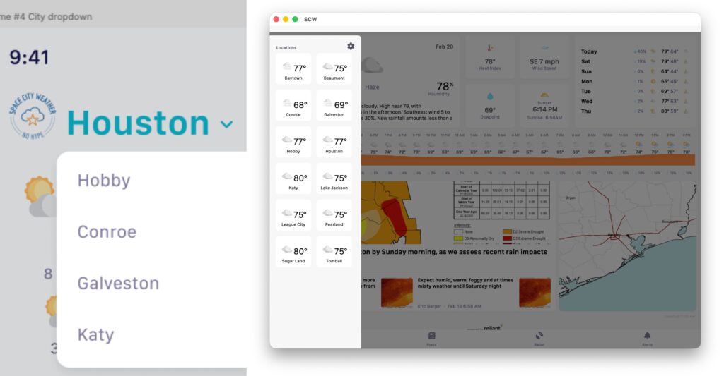
Q. Houston’s such a big place, the weather is all over the place and yes, that pun was intended! Why do you only have 12 cities to pick from on your app? Why isn’t my city/town/neighborhood included?
A. Did you know that the city of Houston covers more than 600 square miles? It’s true! And that one of my favorite jokes about living here is that “Houston is an hour away from Houston”? “A big place” is something of an understatement …
This is one of our most-asked questions. When we first set out to build and release a mobile app for the site, we had to make some hard choices about which locations to include in the city picker (tap the 3-line menu on the upper left corner of the app’s home screen to see it). Eric and Matt tried to ensure that the region got wide-ranging coverage, but we only had five slots in the initial design. We were able to expand to a dozen in later updates, where we remain today.
When the SCW app first launched, there were only five regions to choose from, as seen on the left. Users now have a dozen.
Besides Eric’s & Matt’s judgement calls, there are some technical and design limitations. On most phones and tablets, we didn’t want to force users to scroll through a bunch of city names (though on smaller devices there may be a bit of a scroll), and we wanted to keep the app “lite.”
In addition, we use location-based conditions and forecast feeds from the National Weather Service, and if there is not a feed for a particular city, we can’t provide that data.
Your best bet if you don’t see your exact location in the picker is to choose the city closest to you. Yes, Houston’s spread out, but the weather source nearest you is very likely to have the conditions and forecasting info you need. For example, I live in the Montrose/River Oaks area, so I choose Hobby as my location. That works out pretty well.
One of the other reasons for our current approach is that we don’t track anything you do in the app, and that includes location. But we are considering changing that – location tracking may be added to a future version of the app as an opt-in feature. If you wanted to know the conditions and forecast at your current location, this feature would do that. But again, it would be off by default.
Also, we are looking at the feasibility of adding cities for every available NWS feed and letting users pick their 12 cities – or letting the app choose for you based on location, if you opt-in. A big under-the-hood change planned for this year could enable that. These are all proposals, nothing yet set in stone; let’s just say it’s … aspirational!
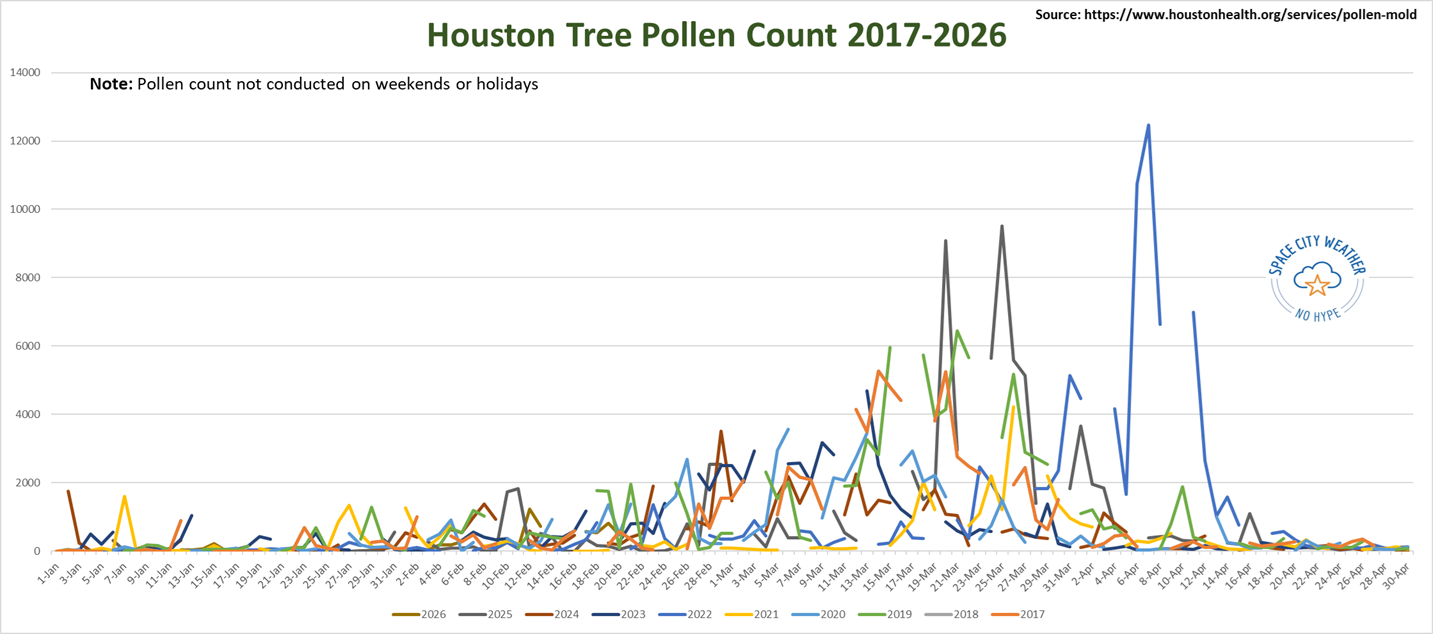
Q. I’ve been dealing with some serious allergies. Have you noticed any data showing a surge in allergens like pollen or cedar? Does this seem earlier than usual for the season, or could it be tied to that big temperature swing from the hard freeze to the 80s this week?
A. This question tends to come up each spring, or late winter as it is in Houston. Is allergy season starting earlier than it has? There’s some evidence in research that says this is occurring as the climate warms. But looking practically at recent data specifically in Houston, it’s a little more mixed. Tree pollen is considered high once levels hit about 80 or so. But the first really, really bad day of spring typically hits when we get to around a level of 500. If you’re curious, the worst day we’ve had since we’ve tracked this back to 2017 was April 7, 2022 when pollen levels exceeded 12,000!
So when has Houston hit that first “500” of the season?
2017: January 4 and again February 9 2018: January 12, 23, and February 2 2019: January 24, 29, and February 5 2020: January 27 and February 4 2021: January 7, several more times through Feb 1, then not again til mid-March 2022: February 18 2023: January 6, 13, 24, and February 7 2024: January 2 and February 1 2025: January 31 and February 10 2026: February 12
What can we make of this? Well, for one it seems like we almost always get 1 to 3 bad allergy days before February. Usually that’ll be a bunch of cedar blowing in behind a cold front with strong winds. But we don’t really see our true “season” establish until around the first week or two of February. From that point of view, this year seems to be right on time, if not perhaps a little late.
Houston’s tree pollen count from January through April; no data on weekends or holidays. (Houston Health Department)
The glaring outlier is 2021, when the mid-February freeze likely caused enough damage to trees to keep pollen from becoming an issue again til March and April. But as you can see from the chart, we are quite early in the game. We haven’t seen anything yet, and it’s likely the next 2-6 weeks will be rough for seasonal allergy sufferers.
– Matt
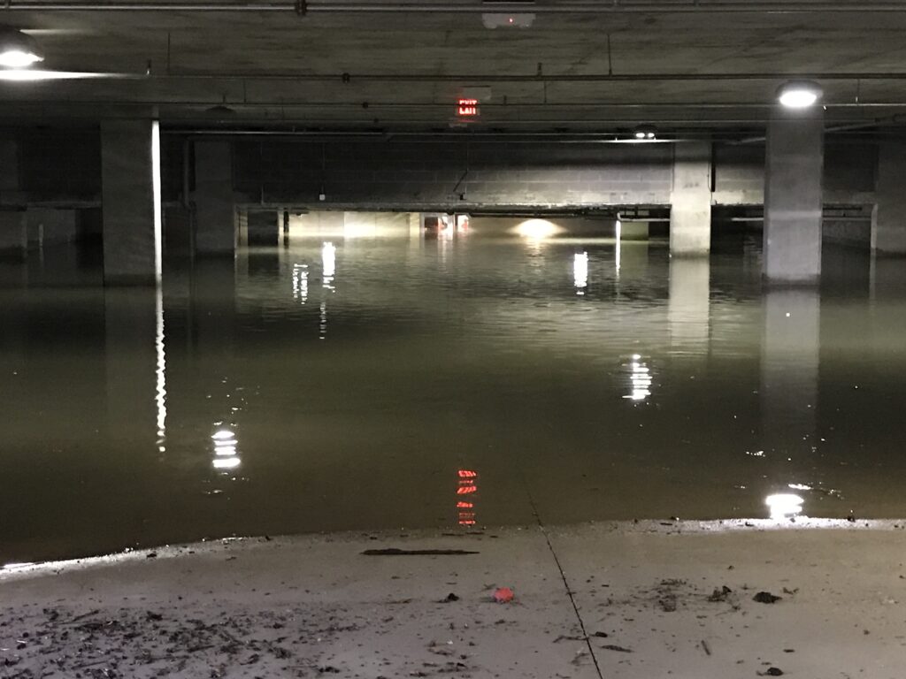
Q. For a while there, it seemed like Houston had a flood every year, sometimes more than one. That seems to have faded in the past few years. Is there a bigger-picture thing happening, or is it just the roll of the weather dice?
A. If you look at the history of Houston flood events, you’ll find a mix of all sorts of years and event types that triggered them. In some ways 2015 (Memorial Day) and 2016 (Tax Day) were just dumb luck thunderstorm events. Neither were “freak,” per se, but they had a sense of randomness to them.
Then, in 2017 Harvey was caused by a remnant hurricane and 2019 was a stalled out tropical storm (Imelda). You are correct that since then, things have tended to be a little calmer. Since 2019, Houston has only had one year of above average rainfall (2024), and of course that was tied heavily to one event (Beryl) and an active spring thunderstorm season. So just generally speaking, we’ve been drier than usual, reducing the overall odds of rain events.
A parking garage at the intersection of Waugh and West Gray flooded badly during Hurricane Harvey after water rushed in off the street. (Dwight Silverman photo)
Also, keep in mind that Houston is merely a dot on a map. Regionally, there have been some bad flooding events since our bad luck finally eased up. News of the recent massive expansion in floodplain coverage across Harris County, however, should give us all pause that while we’ve been more than deserving of a few years of calm, the pendulum will one day swing back again.