Double your pleasure, double your fun; double cool fronts, coming for Houston

Three more days until the heat and humidity breaks. Yes, really.

Friday

It is warm and muggy this morning, and ultimately conditions will be a lot like they were on Thursday. We saw some scattered, late-evening storms fire up just north of Interstate 10 on Thursday, and we may seem a similar pattern on Friday as the sea breeze moves inland—these should be fast moving and not produce too much in the way of rainfall. High temperatures will likely reach the low 90s for most of the area with sunny skies.

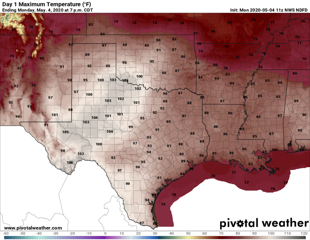
High temperatures on Saturday will be hot, especially for central Texas. (National Weather Service)

Saturday

Did you read Friday’s forecast? Because Saturday will be similar, albeit probably with even less rain shower coverage. Mid-90s will be possible for areas just west of metro Houston.

Sunday

Another warm and sunny day, with highs of around 90 degrees for most of the region. If you’re heading to the Texans game, there will be no issues except for the heat. Because the cold front is unlikely before Sunday night, this will be another summer-like day. But this will be the last one before a much anticipated break.

See full post

Yes, fall really is finally on the way for Houston

After an oh-so-very-long summer we are continuing to make progress toward fall in the Houston area. The region’s cold front remains on track for Monday, and the only question at this time appears to be how strong it will be. Looking a bit further ahead, a second front appears likely by the end of next week, signalling that we truly are moving into a fall-like pattern.

Thursday

Alas, summer will hold on for a while longer. Thursday should be mostly hot and sunny with high temperatures in the low 90s. We can’t entirely rule out some isolated to scattered showers, but most of the region will indeed be dry. It’s going to be another muggy night, where most of the region fails to drop out of the upper 70s. Yeah, we’re tired of those kinds of nights, too.

Summer will rage on today, with highs in the 90s. (Weather Bell)

Friday

A similar story will play out on Friday, although rain chances may step up to about 20 percent by the evening hours as a cold front stalls out well north of Houston. Look for high temperatures again in the low 90s.

Saturday and Sunday

It should be a hot and mostly sunny weekend for the Houston metro area. On the plus side, if you were looking for one more really warm beach or pool weekend—and the last 4,382 this summer haven’t been enough—you’re in luck. It’s going to be warm, with highs generally in the 90 to 93-degree range. Nights may be a shade cooler than we’ve seen, with some slightly drier air backing into the region. Rain chances will be near zero until Sunday night.

See full post

Summer should finally end in six days

Good morning. October has begun like September ended—hot. However there is now strong confidence in the arrival of a cold front early next week, probably Monday evening or night, that will bring substantially drier and cooler air into the region. We’ll discuss just how cool below.

Wednesday

This will be another warm day for the region, with high temperatures generally in the low 90s to possibly mid-90s for far inland areas. With rising moisture levels, we will likely see some scattered shower development south of Interstate 10 before noon, which should migrate north during the afternoon hours. These storms should produce light to moderate rainfall, and keep moving. Skies otherwise will be mostly sunny.

Wednesday will be pretty hot, y’all. (Pivotal Weather)

Thursday

This should be another day like Wednesday, with mostly sunny skies and some scattered showers.

Friday

As high pressure backs off somewhat, temperatures on Friday should maybe hold at “only” about 90 degrees. Skies should remain mostly sunny, with rain chances of perhaps 10 to 20 percent.

See full post

Did Houston just have its worst September weather ever?

Weather-wise, this past September was pretty terrible. There were the floods of Tropical Storm Imelda, which were especially terrible north and east of the Houston metro area. Then there was the heat: Highs were 98 degrees, or above, for the first eight days above, and overall this was by far Houston’s warmest September on record. Finally, the region saw no cool fronts to bring down overnight temperatures, so it remained hot and muggy throughout the month.

Houston had its warmest and wettest September on record. (National Weather Service)

Although this region has had worse extreme weather during past Septembers—such as the landfalls of the Great Storm of 1900 and Hurricane Ike in 2008—I would argue that end-to-end this has been the worst overall September weather in Houston. Good riddance. Fortunately, October promises to be better with a cool front likely in about one week’s time.

Tuesday and Wednesday

The heat continues. With Houston falling under the influence of high pressure the region will continue to see hot and mostly sunny days and warm, humid nights. Expect high temperatures on Tuesday and Wednesday to reach 90 degrees, or warmer, for inland areas. Nights will be extra sticky, with lows for much of the region only falling into the upper 70s. Rain chances remain near zero, except possibly for a few isolated areas near Matagorda Bay.

See full post