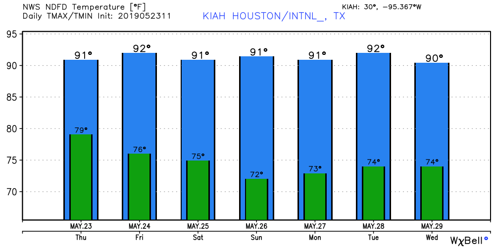
Cloudtober marches on

After a disappointing end to the Astros season, we could use a little sunshine around here to perk us back up a bit. Unfortunately, there’s not a lot of great news looking ahead. We just offer thoughts on the forecast; we don’t control the weather. But we apologize nonetheless.

Today

Today will be another day of clouds and perhaps a couple sunny breaks in spots if you’re lucky. For those of you that missed warmer temperatures, you’ll be seeing some of those return today too. We crested into the 70s in Houston early yesterday afternoon, and we are already running about 10 degrees warmer than yesterday morning (mid-60s). So we’ll probably push the upper-70s today.

Radar as of 5:30 this morning showed heavy rain in spots from Matagorda Bay south to Corpus Christi Bay. (College of DuPage)

There will be a chance of showers and storms virtually anywhere at anytime, but as radar shows, the heaviest rains are likely to stay south of Houston. The Matagorda Bay region has seen the steadiest rains, but so far most places have only seen a quarter to a half-inch or so. As we go into this afternoon, the focus for the best rain or storm chances may shift to west or north of Houston.

Weekend

Our next cold front is in line to cross through the area later Saturday afternoon or evening. Expect a mild, somewhat muggy Saturday morning, with AM lows in the 70s south and east of Houston and mid-to upper-60s north and west. We’ll probably have scattered showers tonight into Saturday morning across the region. Not everyone will see rain though. As the front approaches during the afternoon, we will have another shot at some showers. I am not too impressed by the dynamics of this cold front as it approaches our area, so I am not terribly worried about any significant weather as it passes by. Rain chances will trend toward zero on Saturday night finally.

Most of the Houston area is expected to see a half-inch or less of rain this weekend. By Sunday evening, some areas toward Central Texas or down around Matagorda Bay may see over an inch of rain. (NWS Houston)

Expect temperatures ahead of the front to peak in the mid-to upper-70s south and east. Areas that see an earlier passage of the front north and west of Houston may not get much past the low-70s.

See full post

Oh Mr. Sun, Mister Golden Sun, please shine down on me

Our wet, but not too wet, and cool, but not too cold pattern will continue for the foreseeable future in the Houston metro area. One thing we can guarantee is that while the Sun does exist, there will be little direct evidence of it over the next week. Clouds, and more clouds, will rule the skies.

Thursday

We’ve seen some light to moderate showers in Montgomery County early this morning, but these should exit the region to the north shortly after sunrise. Scattered showers will be possible today, but accumulations should be slight. High temperatures will be warmer than in recent days, likely around 70 degrees, although any regions that do see short breaks could push into the mid-70s. For the most part, just another gray day.

Friday and Saturday

The story heading into the weekend will be surging moisture levels along the Texas coast, and moving inland. For now, the most likely scenario is that these heavier showers remain well to the south of Houston, most likely in the Corpus Christi area, and staying well to the west of Houston. (The hard hit Austin region, where Lake Travis is nearing record levels, could well see more heavy rain this weekend.)

Rain accumulation forecast for now through Saturday evening. (National Weather Service)

For Houston this means a healthy chance (probably around 50 percent) of showers on Friday and Saturday as this moisture moves inland and meets up with an oncoming cold front. For our city and surrounding areas, accumulations are likely to be measured in a few tenths of an inch, but we can’t rule out some heavier isolated storms.

See full post

Dreary weather continues, but we’re holding out hope for Sunday

It’s another cool morning across the region, with highs generally ranging from the 50s up north to the lower 60s along the coast. It is hard to believe we reached 91 degrees only on Sunday, but fall truly has come. Some inland parts of the region may not hit 80 degrees for the rest of this month, although after today we’ll see a moderate warming trend for a few days. If you’re tired of the gray weather, Sunday is your best hope.

Wednesday

Today will probably be similar to Tuesday, with mostly to completely cloudy skies, highs only around 60 degrees for northern areas, and mid-60s for the city. For better rain chances, we’ll need to look to areas far north of the city (i.e. north of College Station or Huntsville) and along the coast and offshore. Chances in Houston will probably be in the 20 to 30 percent range, with what does fall coming down mostly as light mist or drizzle. So basically, another gray day.

Thursday and Friday

Mostly cloudy skies continue, under a northeasterly flow. There’s plenty of moisture toward the second half of the week for the atmosphere to work with, so we’ll probably see more widespread light to moderate rain for Thursday and Friday.

High temperatures should get back into the 70s for most of Houston by Thursday. (National Weather Service)

Accumulations, for the most part, should be measured in tenths. Highs should manage to make it into the low 70s, which is still about 10 degrees below normal levels for this time of year.

See full post

Houston gets a taste of Seattle weather for awhile

Temperatures are generally 20 to 25 degrees cooler this morning across the Houston metro area, with lows in the upper 40s for far inland areas near College Station, in the 50s for most of Houston itself, and the lower 60s along the coast.

Temperatures across the Houston area at 6:15am CT Tuesday. (National Weather Service)

After the influx of colder air, what you see with our weather now is basically going to be what you get. We’re probably stuck with mostly to completely cloudy skies for the rest of this week, and we may see some periodic stormy activity like we saw on Monday.

Tuesday

This will be the region’s coldest day in at least six months, with cloudy skies and high temperatures generally in the low 60s for Houston, and 50s for some inland counties well away from the coast. Rain chances will not be too high today, I’d peg them at around 30 percent, with heavier showers likely remaining well to the north of the area, or offshore. All in all, this will be a rather dreary day. (Until the Astros win this evening, of course).

Wednesday and Thursday

Not much changes for the middle part of this week, with a cooler air mass near the surface, and warmer above, allowing for a thick cloud deck and continued moderate rain chances. All told, I’d expect most of the area to pick up about one-half inch—totals will be highly dependent upon very localized storms—of rain over the next three days. High temperatures will warm into the upper 60s and low 70s for the region.

See full post