Fall, finally

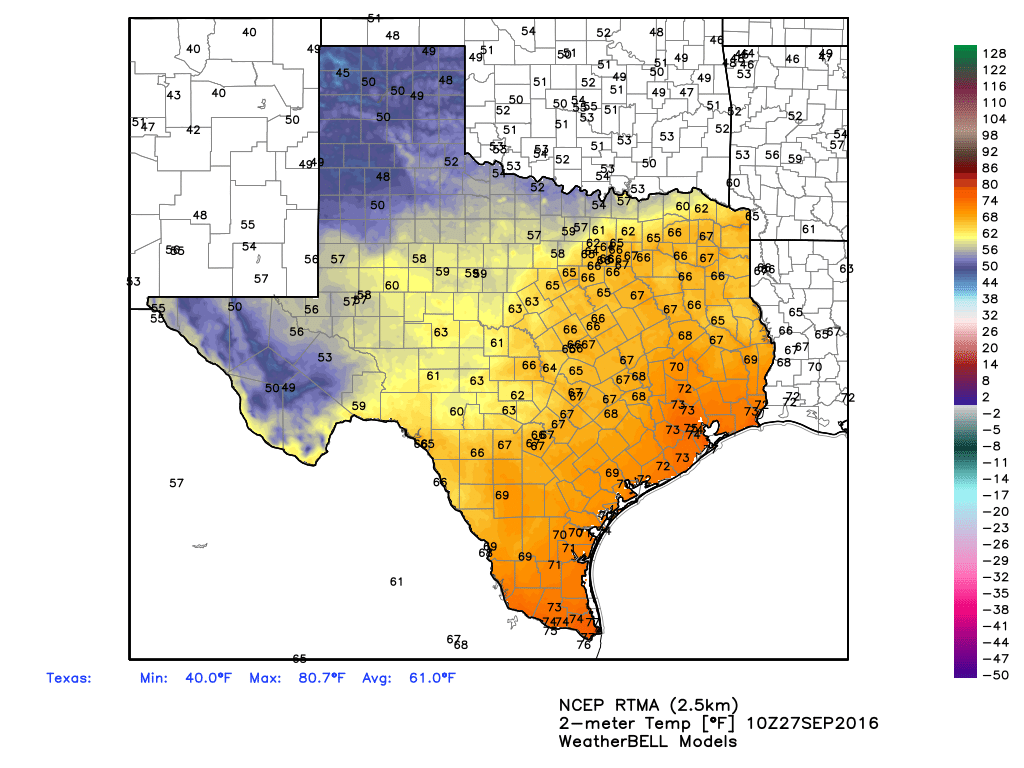
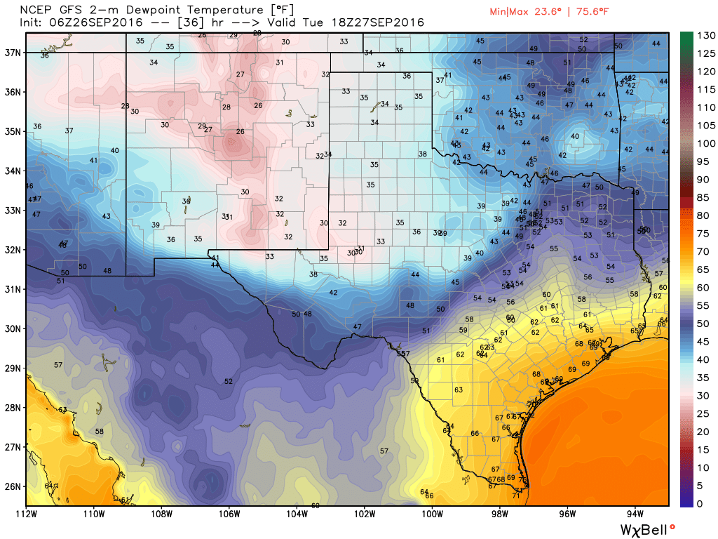
The front that arrived Tuesday morning has finally begun dragging drier air into Houston. Temperatures at Bush Intercontinental Airport fell below 70 degrees this morning for the first time since June 5. It’s not exactly cold, but it is cooler, and drier. And there’s more seasonably pleasant, almost fall-like weather to come.

Today through Sunday

It’s a rather simple forecast for Houston. Drier air will continue to move into the region today, and a reinforcing cool front should arrive on Thursday. Add it all up and we’ll have highs through the weekend in the 80s, with daytime temperatures in the low 80s possible on Friday and Saturday. Overnight lows should be in the 60s except for along the coast (around 70 degrees), and upper 50s for far inland areas, such as College Station. Friday and Saturday should be the coolest mornings.

Northerly winds (here's a projection for Thursday morning) are indeed a beautiful thing. (Earth.nullschool.net)
Northerly winds (here’s a projection for Thursday morning) are indeed a beautiful thing. (Earth.nullschool.net)

All throughout the rest of the week we should see mostly sunny skies, and drier air. It’s not exactly super fall-like, but after more than 100 days of heat and humidity, it’s going to be enough.

Next week

We should see a very gradual warm-up beginning on Monday or so, as winds turn back around from the Gulf of Mexico, and it looks like Wednesday and Thursday or so of next week will bring us briefly back into a muggy, late-summer-like pattern. However, another cool front may well move through, perhaps on Friday or thereabouts. Fall, truly, appears to have arrived.

Tropics

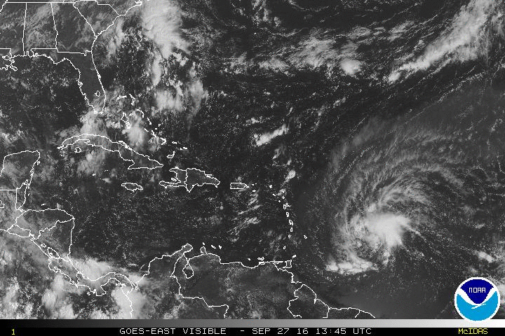
Matt did an excellent job of laying out the status of Invest 99L, which should become Tropical Storm Matthew during the next couple of days as it moves into the Western Caribbean Sea. Looking at some of the overnight model runs it seems increasingly likely that this storm will turn north at some point next week (possibly toward Florida, but more likely toward the Bahamas), as it slogs around the Caribbean. I’d rate the chances of it moving into the Gulf of Mexico as fairly low, and as near zero for it to continue moving west toward Texas. We’ll nonetheless continue to track it.

Posted at 6:50am CT Wednesday by Eric

What to know about the next tropical system

When tropical systems get going, the internet can be a noisy place. So Eric and I thought it would be a good idea to give everyone a user’s guide to the next tropical system that you’ll be hearing about.

What is it?

Invest 97L is the current classification of the tropical wave on the way to the Caribbean. Satellite imagery from late this afternoon shows Invest 97L approaching the Leeward and Windward Islands.

Invest 97L is rotating toward the Caribbean islands this evening. (NOAA/NHC)


“Invests” are the classification given by the National Hurricane Center to tropical disturbances that may develop into organized depressions, storms, or future hurricanes. There are numerous “invests” each hurricane season, and the cycle runs from 90 to 99 and then repeats. Basically, it’s a nice way to keep disturbances orderly in their computer systems for tracking and monitoring purposes.

The National Hurricane Center sent out reconnaissance aircraft today and were unable to find a center of circulation at the surface, so they’ve held off on classifying this as a tropical depression or tropical storm (which will be named Matthew, assuming it gets there). 

See full post

Drier air isn’t to Houston yet—but it will by the weekend

The much-discussed first front of the fall season has pushed off the coast and into the Gulf of Mexico, but drier (and cooler) air has largely lagged behind. As we suggested on Monday, it will be a slow process, but much more fall-like weather is still on the way.

Temperatures this morning show the progress of cold air into Texas. (Weather Bell)

See full post

Front to slowly edge into Houston, second half of week looks stellar

Very heavy rains have fallen over night along the I-35 corridor of Texas, with a focus on Bexar County. Up to 7 inches have fallen in the metro area there. If you are traveling toward the San Antonio area today please take care due to flash flooding occurring across the city. As the front slowly moves into the Houston region today we should see our rain chances pick up, but I do not expect more than 1 to 2 inches of rain for most of the Houston region.

Today

As the front trudges toward Houston we should see an increase in coverage of storms across Houston, especially to the west and north of the city. Highs will be in the mid-80s and I’d expect coverage similar to Sunday, with intermittent heavy rains that might cause some temporary street flooding, but nothing too extreme. The front itself should move through central Houston tonight.

Tuesday

Although the front will probably slog into Houston and off the coast by Tuesday morning, it will take some time for the area see the effects of cooler and drier air. As a result some showers and thunderstorms will remain possible on Tuesday morning, and highs will be possible in the mid- to upper-80s.

(Weather Bell)
Dew points on Tuesday, during the middle of the day. (Weather Bell)

See full post