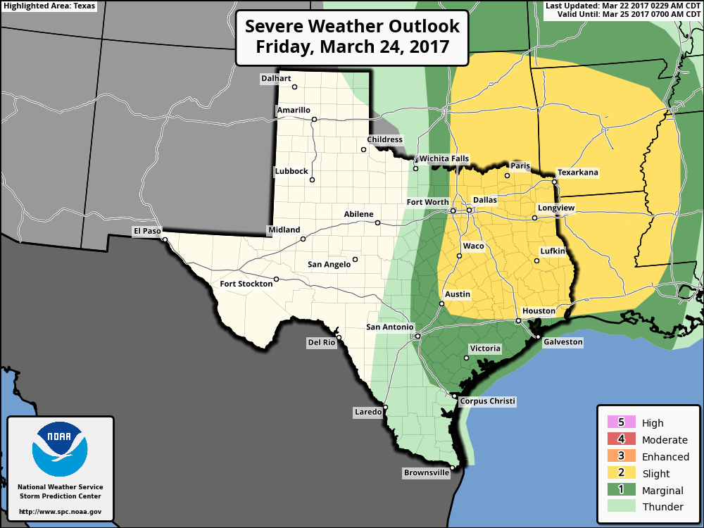
Close, but no cigar: Still no 90 degrees for Houston

Good morning. Houston had another day on Wednesday when the official high temperature at Bush Intercontinental reached 89 degrees, but didn’t tick all the way over to 90. Now only 1897 (June 15) and 1970 (June 12) have gone deeper into the calendar year without reaching this mark. This run has occurred both because of extensive cloud cover in May and early June, as well as wet soils. Houston now hasn’t had a 90-degree day since October 15th.

TODAY and FRIDAY

I think the next couple of days will be a lot like the middle of the week, with the exception that we might see a little bit better rain coverage this afternoon. I expect highs will get near to 90 degrees, or finally break through that threshold. Temperatures will depend on the extent to which cloud and widely scattered rain showers develop over the city this afternoon in response to the seabreeze.

SATURDAY and SUNDAY

Higher moisture levels and a weaker capping inversion should nudge rain chances up to 30 to 40 percent this weekend, but we shouldn’t be too concerned about any kind of severe weather. If rain does develop I’d expect it to be the standard, summer-time rain of fairly short-lived showers during the afternoon and evening hours.

NOAA rain accumulation forecast for now through Sunday. (Weather Bell)

See full post

Summer lite will hang around in Houston for awhile

Well, we were wrong. Houston did not, in fact, reach 90 degrees on Tuesday. The mercury climbed to 89 degrees and stopped. We’re a week into summer, and this year is now tied for the third-latest 90-degree day in a calendar year on record for the city.

WEDNESDAY-FRIDAY

But it has to come today, right? Probably. Skies should be mostly sunny. However if a few stray showers pop up over the northern part of the city, near the official station at Bush Intercontinental Airport, another sub-90 degree day is not out of the question. In any case, the next three days are likely to be a lot like Tuesday—warm, but not too warm. A few showers are possible, especially to the southwest of the Houston metro area.

SATURDAY-SUNDAY

Forecast models continue to suggest muggy air flowing off the Gulf of Mexico will nudge moisture levels higher this weekend. However with high pressure in the region I just don’t see a lot of mechanisms for lifting that moisture into the atmosphere, so it’s not clear how widespread showers are likely to be. In any case, we’re going to see highs in the upper 80s to 90 degrees, most likely, with the best chance of rain in the afternoon. With moisture levels highest on Sunday, that’s probably our most likely time for rain.

NOAA's rain accumulation forecast for now through Sunday shows just a few tenths of an inch for the Houston area. (Weather Bell)
NOAA’s rain accumulation forecast for now through Sunday shows just a few tenths of an inch for the Houston area. (Weather Bell)

See full post

Why weren’t the storms last week considered tropical systems?

This is the latest edition of Weather whys, a series of posts by Braniff Davis explaining the science behind weather phenomenon affecting Texas.

Now that we’ve enjoyed a few sunny days after an extremely wet May and early June, we wanted to tackle a few ‘weather whys’ questions people have asked, either on Facebook, Twitter, or in the blog comments. One reader asked why the weather system last week, which dumped so much rain on the region, was not considered a ‘tropical system.’ After all the system spun counter-clockwise, and had the satellite appearance of a tropical cyclone.

A satellite image from last Friday show a large circulation over Texas. (NCAR)


The answer has to do with how and where different low pressure cyclones form. Pressure, and how it influences weather systems, is vexing. Often, it was the most challenging concept for my students to grasp in my introduction to meteorology classes. We could probably do a 50-part series on the science behind it, called cyclogenesis.  For now, we’ll spare you that and only focus on the large, synoptic scale cyclones that influence our weather.

EXTRATROPICAL VS. TROPICAL CYCLONES

Extratropical cyclone over Pacific Ocean, December 2014 (NOAA)

See full post

Houston likely to record its first 90-degree day today

Well, the party probably ends today. We’ve made it five months and six days into the year 2016, but Houston will likely finally reach 90 degrees today.

Latest dates in the year when Houston has recorded its first 90-degree day. (Matt Lanza)


The forecast beyond this data point is pretty straight forward.

TODAY through THURSDAY

Partly to mostly sunny skies. Drier air should allow highs to reach around 90 degrees. Lows in the low- to mid-70s. A slight chance of afternoon and early evening showers and thunderstorms along the sea breeze. There’s not much more to say than that.

FRIDAY through SUNDAY

We’re going to see more moisture returning from the Gulf of Mexico by this weekend, which should allow for a greater possibility of rain during the afternoon and evening hours. The European model suggests accumulations of a few tenths of an inch of rain for the weekend, which seems about right. I would not expect any kind of a washout.