Heat peaks the next two days before a (very) slight reprieve later this weekend

In brief: Houston will face some of its hottest weather today and Saturday before a weak front makes its last gasp over the area. We cannot rule out a few thunderstorms on Saturday evening, and then some showers on Sunday, but for the most part our weather this weekend and next week is going to be hot and sunny.

Friday

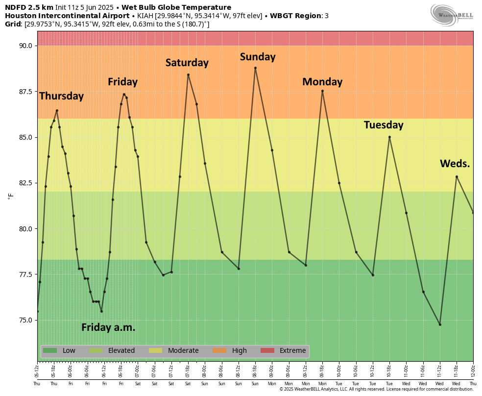
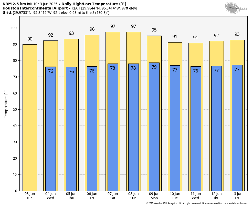
High pressure will be dominant today and for much of Saturday, leading to some of our hottest conditions so far this summer. Friday, therefore, will likely a little bit warmer than we’ve experienced that last couple of days even. Most of the Houston region, away from the coast, is likely to see highs pushing into the upper-90s. Winds will be light, from the south at only 5 mph. With dewpoints in the mid- to upper-70s, the air will feel sticky. Low temperatures tonight will only fall to around 80 degrees for much of the city. So yeah, this will be full-on summer in Houston.

Houston’s temperatures will reach borderline extreme levels before backing off slightly, based on Wet Bulb Globe Temperatures. (Weather Bell)

Saturday

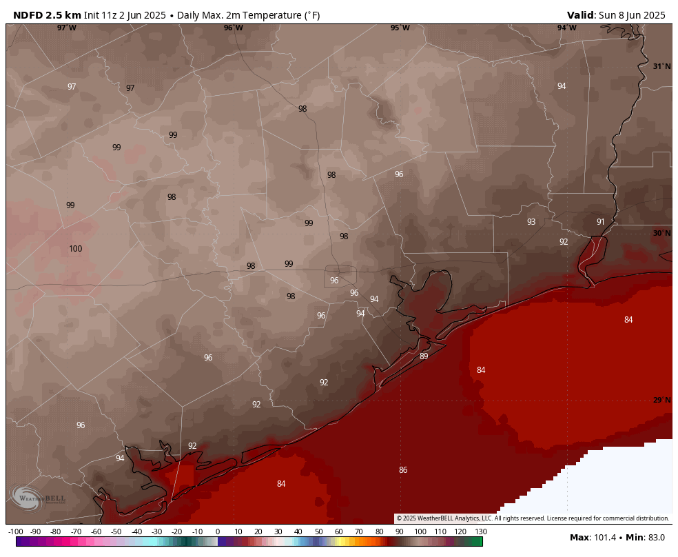
The first half of the weekend is likely to be even a touch warmer than Friday. This will be due, in part, to the advancement of a weak front that will eventually fizzle out over the Houston area. What happens as a front advances is that, typically, it compresses the air ahead of it downstream. The front is fairly weak, but this compressional heating could be enough to add a couple of degrees on Saturday. Therefore I expect most of the region to reach the upper 90s, with a few locations possibly hitting 100 degrees. Skies will be sunny during the daytime. I do think it’s possible that we see some isolated or scattered showers on Saturday evening, with the possibility of thunderstorms. So while these aren’t probable, they are possible.

Sunday

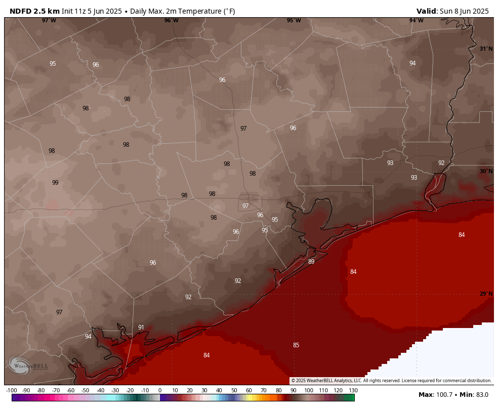
The front should bring a few degrees off the top end of our temperatures, so highs on Sunday will likely drop back into the mid- to upper-90s. There is also a decent chance of showers on Sunday and Sunday evening. By decent I mean maybe 30 percent for areas along and south of Interstate 10, and 20 percent further inland. Mostly, however, our skies will be sunny and the air plenty humid still—sorry, it’s a very weak front that will fall apart as it pushes into the region. Lows on Sunday night will drop into the upper 70s.

Next week

Most of next week looks sunny and hot, with high temperatures in the mid- to upper-90s. There will be a smattering of rain chances, but they’re low overall, perhaps 10 to 20 percent daily. Mostly, it’s just going to feel like Houston in August. For most of us, that’s pretty miserable. But aside from the heat we should have no worries about storms or the like, which is nice after what Houston has experienced so far this spring and summer.

Our model guidance for Invest 97L is becoming much clearer. (NCAR)

Tropics

The forecast for the tropical disturbance AL97 is coming into better focus, and it looks to be a rainmaker for Florida and potentially the US East Coast this weekend and into early next week. As we’ve been saying for a few days, there is zero threat to Texas from this system. We’ll continue to track the storm in depth today, and this weekend, on The Eyewall.

Welcome to August, by far the worst month of the year. Just 31 days to go.

In brief: This post discusses the month of August, and why it is the worst month of the year for weather in Houston. It also delves into our hot and hazy weather ahead, and takes a peek at a tropical system that’s near Puerto Rico and may be a rainmaker for Florida next week.

A word about August

This month is named after the Roman emperor Augustus, who is considered by some historians to be Rome’s greatest ruler, and by others a tyrannical usurper. His greatest crime, however, is renaming this month after himself. Prior to that little matter of self-aggrandizement, the month was called Sextilis. That would have made an interesting naming choice for our hottest and steamiest month.

This plot shows that August has the warmest days and nights of the year. (National Weather Service)

In any case, August is the worst month because it is the hottest month of the year in Houston. And we typically vacillate between the extremes of drought and flood, sometimes within a matter of hours. There is no happy medium. There is no break from the humidity. There is only August. It is also the month, alongside September, when we are most vulnerable to landfalls from major, destructive hurricanes. Now my colleague Matt Lanza will argue that September is worse. Why? Because September can also be hot, and there is the often false hope of a a cool front. But let me tell you, Lanza is dead wrong. I have lived through enough Septembers in Houston to know that we very often do get our first front in September, and it feels glorious.

Anyway, August is here. It’s always hot. It’s always humid. Let us fervently hope it is hurricane-free.

Thursday

There will be plenty haze again today, which will fade the blueish nature of the sky, as we continue to see an influx of Saharan dust. This haze, at varying levels, should remain with us through Saturday or so. Otherwise, beneath high pressure, we should see sunny skies and hot temperatures in the mid- to upper-90s. Winds will be light, out of the south or southeast, at 5 to 10 mph this afternoon. Lows tonight will only drop into the upper 70s. And humidity—well, you should know whether to ask about humidity in August.

Friday and Saturday

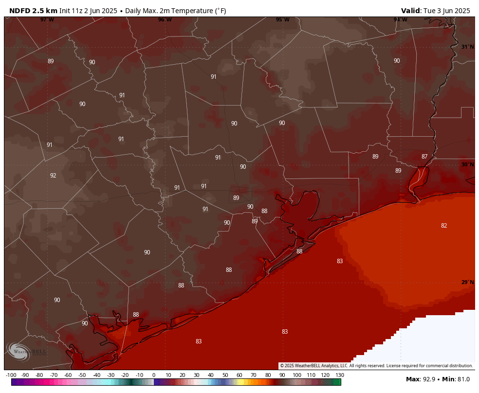
Temperatures will likely peak these days, with high temperatures likely in the upper 90s for much of the metro area. As mentioned above, we should still see a fair bit of haze from dust. However, beyond the haze we’re going to see sunny skies and rain chances below 10 percent. These will be good beach days or otherwise suitable for outdoor activities near water.

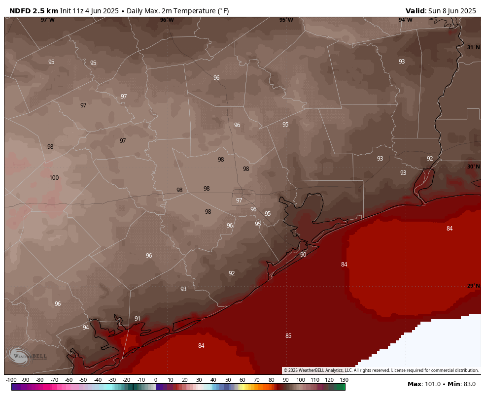
Saturday’s high temperatures look rather hot. (Weather Bell)

Sunday and Monday

A weak front is going to near the Houston region on Sunday, and this may bring a few more clouds. (Although I’m still going to bet on mostly sunny skies). Rain chances will be a little bit higher, but still on the order of only about 20 percent daily. Temperatures may fall back a degree or two, into the mid- to upper-90s. Still, it’s going to be plenty hot.

Remainder of next week

We’ll continue to see hot and mostly sunny weather for much of next week, with highs in the mid- to upper-90s. There’s the slight potential for some sea breeze showers each afternoon, and maybe some slightly better rain chances toward the end of next week. But I’m not sold on that.

Tropical outlook for Thursday morning. (National Hurricane Center)

The Tropics

I’ll have more on the The Eyewall later this morning, but the forecast for a tropical wave that is now nearing Puerto Rico continues to fluctuate. For now it looks like a weaker system will move into the eastern Gulf of Mexico and eventually move north toward Florida. Then it may spin around awhile before finally lifting north. This is very likely not an issue for the Western Gulf of Mexico, but is definitely something to watch for Florida and parts nearby.

Summertime weather will prevail for awhile as dust arrives overhead

In brief: With high pressure in place this week, expect hot temperatures, mostly sunny skies, and few if any stray showers. The only real feature of note, beyond the heat, will be hazy skies due to the influx of Saharan dust into the atmosphere. Rain chances increase slightly by Sunday as a weak front stalls north of the metro area.

Wednesday

Weeks like these, which often come during the summertime months in Houston, are easy to forecast in Texas. With high pressure more or less in place we can expect sultry but calm weather. And that will be the case today, with mostly sunny skies and high temperatures generally in the mid-90s. Winds will be from the south at about 5 to 10 mph, with some higher gusts this afternoon and during the early evening hours. Low temperatures will briefly drop into the upper 70s tonight for inland areas. Rain chances are below 10 percent.

Oh August, I have not missed thee. (Weather Bell)

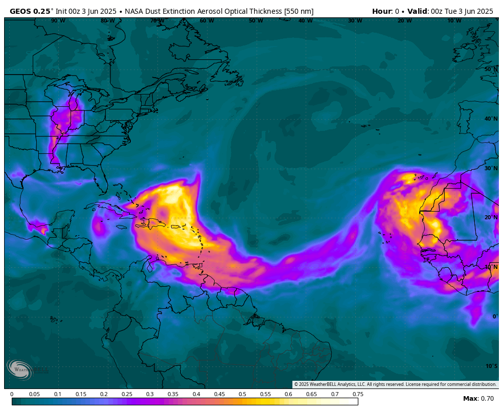
The main novelty for today, and much of the rest of this week, will be the presence of haze due to the Saharan air layer. These are fine particles of dust from Africa, transported across the Atlantic Ocean all the way to Texas. This pattern typically peaks during July so it is not abnormal to see this dust, nor particularly harmful. Sunsets will appear a deeper red.

Thursday

A day a lot like Wednesday.

Friday

We may start to see a bit less dust in the atmosphere, and with sunny skies most of the area could see highs push into the upper 90s.

Saturday and Sunday

High pressure will retreat some this weekend, and a weak front will approach the region but stall out well north of us. With that being said, I’m not sure there will be a whole lot of sensible change in our weather. Saturday will be sunny and hot. We may see the return of some African dust for a bit, we’ll see. Sunday looks sunny and hot as well, but due to the presence of the front we could see some isolated to scattered showers develop during the afternoon hours.

Next week

High pressure appears to be back in play next week, so we can expect to see continued temperatures in the mid- to upper-90s as we get deeper into August. There does appear to be some support for higher rain chances during the latter half of next week, but when we get into these drier patterns these kinds of showers are sometimes a mirage in the models. We’ll see.

Tropical outlook from the National Hurricane Center.

Tropics

The main focus continues to be on a tropical wave approaching the Caribbean Sea, which is likely to near the Bahamas in a couple of days. It may take some time, but forecasters at the National Hurricane Center expect this system to eventually get its act together and become a tropical depression or storm during the next week. The primary threat in terms of winds and rains looks to be across Florida, but there’s not a lot of certainty in the models.

Saharan dust arriving soon as Houston starts to feel like it should during August

In brief: Houston jumped back into the mid-90s on Monday, and that’s where we are going to be for awhile as high pressure dominates our weather this week. Aside from the heat, which will be high but far from exceptional for this time of year in Houston, we have few concerns. This post will also discuss the tropics, which are awakening from their mid-July slumber.

Tuesday

The main difference today, from Monday, is that we’ll see a slightly better chance of some showers and thunderstorms this afternoon. It’s definitely just a puncher’s chance, with perhaps 10 or 20 percent coverage, but you may hear a few rumbles later today. We should also start to see the onset of some haze later today, due to Saharan dust that has traveled all the way across the Atlantic. This should pose no health concerns, and is beneficial for our soils. Sunsets should also be great this week.

The Saharan air layer in the tropics can be seen in this split image from the GOES-16 satellite, in which you can also see an intrusion moving into the Gulf of Mexico toward Texas. (NOAA)

High temperatures today, like on Monday, will push into the mid-90s for most locations away from the coast. Skies will be partly to mostly sunny. Winds will be from the south at 5 to 10 mph, with a few gusts of 15 mph or higher this afternoon. Low temperatures should briefly drop into the upper 70s tonight, away from Houston.

Wednesday and Thursday

These will be a pair of hot and sunny days, with high temperatures mostly in the mid-90s, but with the possibility of some inland locations sneaking into the upper-90s. Winds will be from the south at 5 to 10 mph, but Wednesday at least should see some slightly gustier conditions during the afternoon hours. Rain chances are likely 10 percent or less. Haze should be most predominant on these days, so if you look up, you’ll be staring into African dust. It’s a big world, but it’s also a small world.

Friday

Our weather for this week will mostly be guided by a high pressure system. However, by Friday or so, that system should begin to back off a bit. This may introduce a slight chance of showers, perhaps on the order of 20 percent or so by Friday. Otherwise, expect mostly sunny skies and highs in the mid-90s.

Saturday

The first half of the weekend looks to bring sunny skies, with high temperatures generally in the mid-90s. If I squint I can see the possibility of some rain showers, but overall chances are around 10 percent or less. It should be a good beach day after a long period of not-great summer weekend weather. I can’t believe school starts in just a couple of weeks.

Houston’s heat this week certainly looks high, but it should not be extreme. (Weather Bell)

Sunday, Monday, and beyond

As mentioned above, as high pressure backs off a bit, we should see some slightly cooler weather—think lower- to mid-90s rather than mid- to upper-90s—and some daily rain chances in the ballpark of 20 to 30 percent daily. Skies still look to be partly to mostly sunny, for the most part. All in all, this weather looks to be fairly benign for early August in Houston, typically the hottest time of the year.

Tropics

Speaking of non-benign things, as we get into August the Atlantic tropics start to heat up. Matt has got you covered on the Eyewall when it comes to a tropical wave that could threaten the Bahamas, and maybe eventually Florida. As for the Texas coast, there are no concerns from that system, nor anything else at this moment. Let’s hope things remain that way.