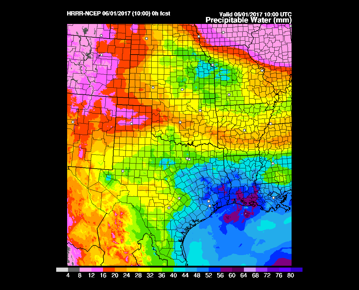
Lovely weather to end the work week, but heavy rain likely returns Sunday

As expected a large complex of showers and thunderstorms moved through the greater Houston area during the overnight hours, bringing 1 to 1.5 inches of rain for almost everyone.

TODAY

Showers will continue to be possible today for coastal areas and to the east of Houston, but for most areas the heavy rains have ended for good today. With mostly cloudy skies today we should see highs in the low- to mid-70s along with light northerly winds.

THURSDAY and FRIDAY

High pressure will make for great weather to end the work week, with highs near 80 degrees, morning lows in the low 60s, and partly to mostly sunny skies. This will be great weather for April.

See full post

Heavy rain possible tonight and Wednesday, then pleasant weather until the weekend

Thus far what was supposed to be a “wet” week has mostly been a dud in the rain department. However I still expect that to change on Wednesday, when there’s the potential for heavy rain.

TODAY

A weak front is moving through Houston this morning, however it’s going to stall off the coast, and not going to bring much cool air. Highs will be around 80 degrees today, and even with the frontal boundary we’re going to see moisture pooling over coastal areas. This will allow for a chance of light showers today, and the potential for heavy rain tonight and on Wednesday.

WEDNESDAY

Because of the front’s proximity to the coast, very high moisture levels, and favorable conditions in the upper atmosphere we’re going to see rain between late Tuesday night and noon on Wednesday. For Houston I’d guess the heaviest rain comes between about midnight and sunrise. Coastal areas could see widespread totals of 1 to 2 inches of rain, with lesser amounts inland. In addition we can’t rule out some isolated flooding where rain showers are heaviest. That’s always a concern when the atmosphere is this moist. Fortunately as high pressure moves in by Wednesday evening we’ll see an end to shower activity.

Rain accumulation forecast for tonight and Wednesday. (National Weather Service)

See full post

Storms possible later today, heavy rain perhaps on Wednesday

Good morning. A few areas have picked up some light rain this morning, but the forecast models that predicted reasonably heavy showers for the region this morning have largely busted. That does not give me great confidence in the forecast for the rest of the day.

TODAY

The big question is whether a capping inversion over the region will break, or not, today. As an atmospheric disturbance moves over Texas today this will create a fair amount of atmospheric stability such that, if the cap breaks we’ll probably see some significant showers and thunderstorms. According to NOAA’s Storm Prediction Center the primary threat will come from hail and wind damage, with a very slight chance of tornadoes. Right now any severe weather that does develop seems more likely to the north and east of Houston, rather than the south and west where the cap is weakest.

My best guess for rain totals today is less than one-half inch of rain south of Interstate 10, and the potential for one-half or more north. But after this morning’s bust my confidence is not high.

An atmospheric disturbance will bring a chance of storms later today. (NOAA)

See full post

Monday could be wet—and Wednesday wetter still

A lot of people have been asking for when it might rain next, and now the forecast is becoming more clear. So here’s a quick weekend update on rain chances for the next few days.

MONDAY

If you’ve been outside today you’ve probably felt the increasing moisture levels, and seen some clouds. That’s atmospheric moisture returning to Houston, and high resolution forecast models show the possibility of locally heavy rain on Monday morning, from a few hours before sunrise through around 9 a.m. I’d characterize the uncertainty about amounts of rain as “high,” but there’s definitely the potential for some areas to pick up a quick inch of rain. Most parts of Houston, however, are more likely to only see a tenth or two of an inch of rain during the morning hours.

Another round of showers is possible in the afternoon, however the better chances for rain, and possibly severe weather, lie well to the northeast of Houston later on Monday.

Storms are possible Monday to the northeast of the Houston metro area. (NOAA)

See full post