Yesterday was a classic mid-spring like day in Houston. We hit 84 degrees, which makes it the warmest day of 2016 so far. We won’t be pushing that the next few days, but it will stay warm.All the details below, and scroll to the end for an important article you should be reading today.
TODAY
I won’t implicitly suggest today is a good day to play hooky, but it’ll be awfully nice. Expect plenty of sun, low humidity, and temperatures roughly 10 degrees cooler than Thursday (mid-70s). Another winner.
Good morning. It’s quite a bit warmer out, as expected, with a muggy start to the day and temperatures in the upper 60s.
TODAY
A cold front is coming, likely reaching the central part of the metro area by about noon, and pushing off the coast late this afternoon. Expect breezy conditions along with and after the front. We’ll see quite a warm day, with highs in the low 80s, before temperature cools off tonight as the Sun begins to set. Also, much drier air is moving in behind the front.
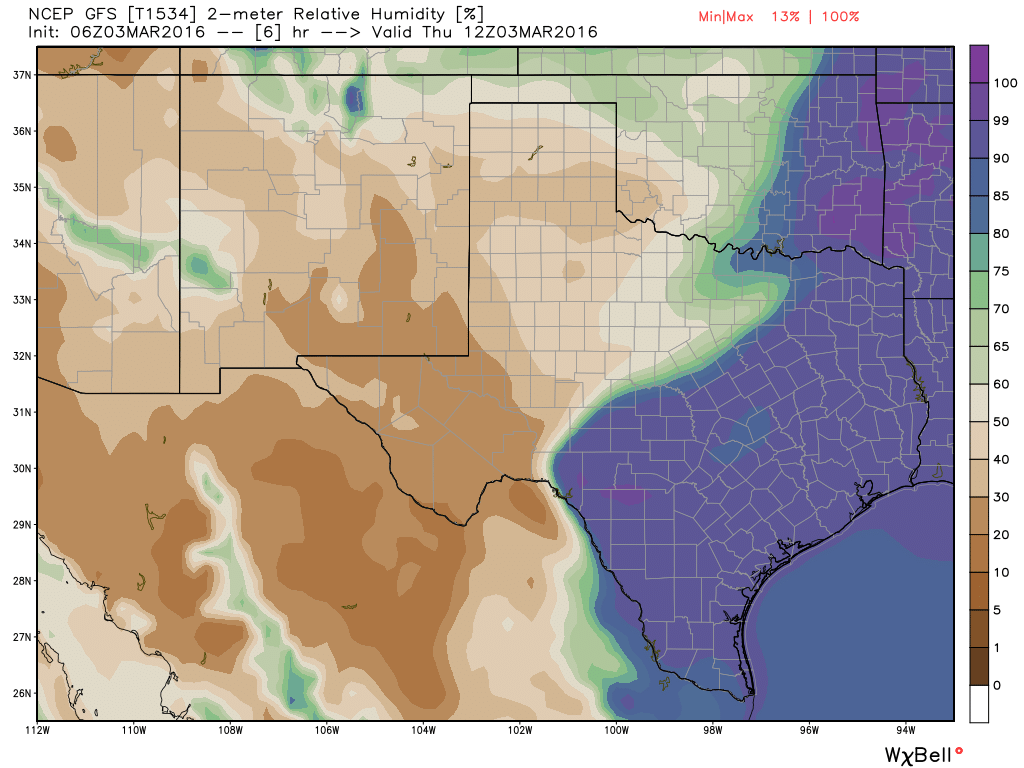
This relative humidity forecast for 6 a.m. this morning shows the stark difference in front of, and behind a cold front coming down through Texas. (Weather Bell)
Good morning. After a weak cool front crossed the region later on Tuesday we’re seeing more normal temperatures for this time of year, with lows in the low 50s.
TODAY
A northerly flow will hold temperatures in the low 70s today under mostly sunny skies. However the front will wash out, and winds will resume from the Gulf of Mexico this evening, which in turn should prevent low temperatures from falling below 60 degrees.
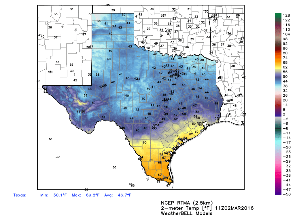
A cold front has worked its way through most of Texas this morning. (Weather Bell)
THURSDAY
We’ll see fairly warm conditions, with highs near 80 degrees, before a second cold front arrives later in the day. This will drive lows down to near 50 degrees by Friday morning. Although we can’t rule out a stray shower with the front, I don’t expect any rain.
FRIDAY
After a relatively cool start to the day, highs on Friday will climb into the mid-70s under mostly sunny skies.
THE WEEKEND
We’ll continue to see seasonably warm conditions for the weekend, with highs in the mid-70s, under mostly sunny skies, and lows around 60 degrees. It will certainly be pleasant, but you might like the nights to be cooler.
NEXT WEEK
I’m still seeing a pattern change in the upper level of the atmosphere that will draw more moisture toward Texas early next week. We should see scattered to widespread rain showers from Monday through Wednesday, depending on the storm track, and mostly cloudy skies. It’s a bit too early to forecast rainfall amounts.
Good morning. After any fog burns off this morning we’ll see a warm, mostly cloudy day.
TODAY
With moisture flowing back into the region from the Gulf of Mexico, and a weak cold front due to arrive later this afternoon or evening, there’s a chance of scattered rain showers today. But most areas probably won’t see any rain. Highs before the front should rise into the upper 70s, and lows tonight in the lower 50s.
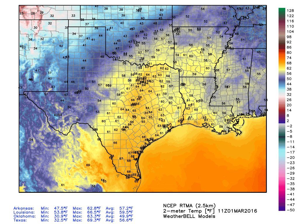
As temperatures this morning show, a cold front is coming — but it won’t be here until this evening, and it will modify quite a bit before then. (Weather Bell).