Good morning. The focus for moderate to heavy rainfall has shifted to the coast and offshore this morning, putting down a considerable amount of rain in locations near Matagorda Bay. The Houston metro area will continue to see healthy rain chances through at least the middle of next week, but accumulations do not look all that significant, such that we should be worried about flooding. We also need to keep an eye on the tropics, which may start to blossom as we approach Labor Day Weekend. We’ll discuss all of this below.
Thursday
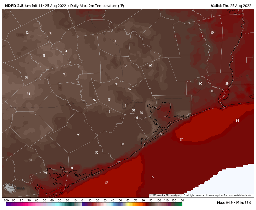
With a weak boundary set up along the coast today, that’s where the bulk of the precipitation will lie. If you live north of Interstate 10, skies should be partly to mostly sunny, with highs in the low 90s, and low rain chances. The closer you get to the coast, the greater the chance of clouds and rains, and accordingly highs should only reach the upper 80s to 90 degrees. Right along the coast, accumulations of 1 to 3 inches of rain are possible, but amounts will be much lower for areas just a bit inland. Winds will generally be light, out of the north. Lows tonight will be in the upper 70s.
Friday
Houston’s atmosphere will remain in an unsettled pattern on Friday, and for the next several days, due to the absence of high pressure and fairly high atmospheric moisture levels. However, there appear to be no triggers for rainfall, so we’re looking at a pattern where showers and thunderstorms are likely during the afternoon and evening hours, along with daytime heating and the sea breeze. Accordingly, expect highs in the low 90s on Friday, with partly sunny skies, and about a 50 percent chance of showers and thunderstorms during the afternoon and evening.
Saturday and Sunday
This forecast should more or less hold for the weekend. If you have morning plans outdoors, they should be fine. Things may become a little more challenging during the afternoons and evenings, with the potential for a passing shower or thunderstorm. Expect highs in the vicinity of 90 to 95 degrees.
Next week
As we head into September, don’t expect too much of a pattern change. We’ll continue to see highs in the low 90s, for the most part, with a healthy chance of afternoon showers and thunderstorms. These conditions will probably hold until the second half of next week, as we approach Labor Day weekend. After that time our weather may be influenced by the tropics.
Tropics
So far it has been an exceptionally quiet August for the Atlantic tropics, but we continue to see signs that is going to change. Moreover, one of the systems we’re watching has a decent chance of moving into the Gulf of Mexico in about a week or so from now.
To illustrate this let’s take a look at an ensemble forecast from the European model, which runs a few dozen variants of the main model to provide a range of outcomes. This is useful because if a lot of ensemble members have similar forecasts, then we can have a reasonable amount of confidence in such a forecast coming to pass. Below, in the ensemble model’s forecast for one week from this morning, we can see the European model pinpointing three different areas for development.
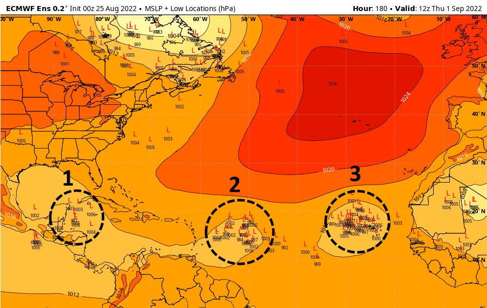
Of most concern to us is the blob I’ve marked “1.” Both the European and US GFS models have been highlighting this potential for a couple of days, and I’d say there’s a pretty good chance that some sort of tropical system, whether it be a disorganized area of thunderstorms or a tropical storm, will reach the northwestern Caribbean Sea by Wednesday or Thursday of next week. After that, it probably would move into the Gulf of Mexico. It could really go anywhere after that, but the most likely locations would be Mexico, Texas, or Louisiana. The bottom line is that we’re looking at the possibility of a tropical system in the Gulf of Mexico as we head into Labor Day weekend.
This is not something you should panic about, by any means. The storm must overcome wind shear and a host of other obstacles. But as we get into late August and early September, we’re going to be watching all of these waves closely, because the next month is prime time for Gulf of Mexico hurricanes.
A message from Reliant, our sponsor
As Eric and Matt closely watch the tropics for us, Reliant wants to encourage Texans along the coast to start preparing – even before a storm is brewing. The first 72 hours after a storm hits are the most crucial to save lives. Supplies like bottled water, backup power, shelf-stable food, first aid kits, emergency blankets, waterproof protection for documents, signaling glow sticks and whistles are important to have gathered in advance. You can find a helpful storm prep checklist at the Reliant Storm Center.
If you live in Fort Bend County, Reliant is teaming up with its parent company, NRG, and nonprofit Attack Poverty to distribute 2,500 emergency preparedness buckets that come with many of these supplies. The next distribution is on Saturday, August 27. Location and timing details are released 24-48 hours before and can be found at https://attackpoverty.org/response/preparedness/.

I moved in 2021 cause I was tired of hurricane weather. Last year was mild season for Houston (not LA though). Hmmmmm
Do you think that with the “delay” of the season, the activity of storms will last longer this year like into October?
No. Climatologists are just guessing. Don’t be alarmed by their fear mongering. And man isn’t causing whatever climate change there “might be”.
Well, I’ll definitely take your word for it over everything else I’ve ever read on the subject. You are, after all, a Guy On The Internet.
He is talking about the above average forecast for this year, not climate change, in case you didn’t guess.
I don’t know, but the build-up of heat in the Gulf is concerning me. It has to dissipate one way or another. Cooling down due to lower sun angle, evaporation, and mixing with cooler water takes time. A major hurricane or two is much quicker.
Tryin to Reason with Hurricane Season!
Absolutely nada around here rainfall-wise these last two days.
Figures …going out of town over Labor Day weekend.