Good morning. Houston will see a significant pattern change over the next few days, as a weakening ridge of high pressure allows for the influx of tropical moisture that will increase cloud cover and rain chances. This should bring cooler weather—some areas may have seen their last 90-degree days for awhile—and some much needed rainfall.
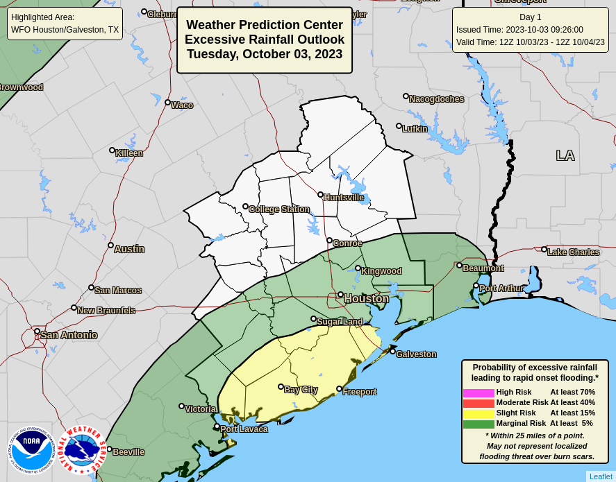
Given the tropical nature of this rainfall, some locations may see in excess of 4 inches, and this could lead to street flooding. For that reason, we are instituting a Stage 1 flood alert for areas south of Interstate 10 through Thursday. As usual in Houston, rainfall totals will be highly variable from location to location. So while you may not see heavy rainfall at your house, a neighborhood a few miles away may well be. A Stage 1 flood alert simply means that you should be aware of the potential for street flooding, not to expect widespread mayhem.

The overall pattern will also favor heavy rainfall across other parts of the state this week, including the Dallas-Fort Worth metroplex later on Wednesday and Wednesday night. Matt will be covering the threat of rains and flooding across other parts of Texas, including San Antonio and Austin, on The Eyewall this morning.
Tuesday
We’re starting to see showers move in from the coast this morning, and most of the area has about a 60 percent chance of rainfall today. The threat of heavy rainfall is higher closer to the coast and source of moisture, which is why we’ve put in a State 1 flood alert for areas south of Interstate 10. Highs today will be dependent on local cloud cover and rainfall amounts, but I suspect that much of the area south of I-10 will top out in the upper 80s, while areas further inland have the potential to reach the lower 90s. Rain chances will slacken some on Tuesday night, but not go away entirely.
Wednesday and Thursday
The region will remain in a favorable environment for rain showers on Wednesday and Thursday, with plenty of atmospheric moisture to work with and an unstable environment. Showers may be especially pronounced on Thursday afternoon or evening as a cold front pushes down into the area and slows down. In any case, we’ll continue to see the threat of some street flooding in areas where the heavier rains setup. Rain accumulations will likely vary between 1 and 5 inches across the region this week, with the highest totals to the southwest of Houston. Highs will probably top out in the upper 80s with partly to mostly cloudy skies for most areas.
Friday
The front will push into the area later on Thursday and Thursday night, but we’re not going to feel its effects right away. However, with mostly cloudy skies on Friday, I do think highs will top out in the mid-80s. Some decent rain chances will remain on Friday as drier air will lag behind the front’s passage somewhat. Lows on Friday night will drop into the upper 60s.
Saturday and Sunday
The drier air you’re all waiting for should finally start to arrive with a reinforcing front on Friday night into Saturday morning. Some rain showers will linger on Saturday, and skies will likely remain mostly cloudy throughout the day. Would you believe me if I said highs may top out in the upper 70s? Well, I think that’s possible. Moreover, most of the area inland of Interstate 10 probably will drop into the upper 50s on Saturday night. Sunday looks to be the pick of the litter, in terms of weather, with highs in the mid-70s and partly to mostly sunny skies. No kidding. Lows on Sunday night will be modestly chilly again.

Next week
By Monday or Tuesday of next week our weather should be back into the 80s, with increasing humidity. But I don’t think we’re going back into full-on summer, and there are some hints of another front by around next weekend. That’s not something I’m fully confident in, however.


😯
That’s wonderful!
Is it just as likely for the bullseye to occur right over the Galleria, compared to where it is this morning, just southwest of the city? Or is there something about this setup that really favors coastal/southwest for the most rain?
So we’ve been experiencing higher tides than normal over the last week along Galveston bay and Clear Lake. Has this been simply due to the stronger east winds or moon phase? Do you think the rain over the next couple of days on top of higher tides will result in impactful flooding along the coastal areas?
Hey Ash your comment got me thinking about generally rising water and sunshine flooding. The Thwaites glacier news is getting more mainstream. Anomalous low sea ice at the start of warm down there. You might check it out. Nothing imminent, but it’s kept me from buying anything low level. National Flood Insurance Protection is getting expensive. Need more policy holders to spread the load.
To quote the old Garbage song: “I’m only happy when it rains.” But, we could all use a good soaking and the rainclouds block out the sun to cool things off for a change. Overall, good stuff.
Then, the best part is the coming cool front. I’m practically giddy with anticipation.
I’ve that song lol. I can definitely relate
Is it too early to start telling people not to panic by the “modelcane” development in the Bay Of Campeche next week? Those catchy social media headlines are likely to crank up in the next day or two selling fear. It is October and usually the tracks of these storms (if they develop) pull storms off to our east…
I think you made your point yesterday. And maybe it’s our turn. My goodness. Hobby is 17” below normal rainfall. Bring it.
No lie. I’m 16 inches below normal for the year where I live.
Did we have wind gusts with this rain this morning? I was surprised to find a sizeable tree branch in the yard this morning.
When I was awakened by dripping noises this morning my first thought was, ‘Huh? It can’t possibly be raining!’. Goes to show how bad it has been this year.
What changed overnight that the rain forecast increased significantly for today to the point of Stage 1? Happy to have it, just curious what shifted. Thank you!
Phenomenal forecast!! Rain then some cooler temps! Desperately need both!
In the rainfall chart it mentions “burn scars” at the bottom. I’m not familiar with that term. Can you explain, please?
The soil in areas where wildfires have been can become quite impervious to rainfall. That and the lack of vegetation can cause flooding with rainfalls that wouldn’t normally be an issue.
Burn scars are areas which are recently burned by fire. The burnt material (ash), is finer-grained, soft, loose, and more susceptible to erosion with rains and/or leading to more quick runoff, thus increasing flash flood risks. The note there on the legend is just to say that these are generalized risk maps and NOAA doesn’t account for any specific burn scars in the map, so local risk may be higher than shown if you live in an area which recently had a fire event.
This is so awesome. I never want to see the sun again.
Waters Edge community has their National night out scheduled for 5:30 this evening. They have to make a decision to cancel or not by 1 PM. They are located in the east side of Lake Houston between beltway 8 and 1969 on West Lake Houston Parklway. Could you give us your best recommendation? Thx so much.
Hate to focus on the scary part, but not fully confident we arent going back into full on summer???” Please, God, no.
Well, today’s high temp forecast for my area was 94. Actual high temp was 81. Forecast rain was .51″ . So far, rain has totaled 1.42 inches and it’s still falling strongly. So, I’d say today’s forecast was a miss.
I’ll take that “miss” any day of the week. After only getting 0.3” since July, my neighborhood picked up a juicy 2.5” precip. It’s looking greener already!!!!