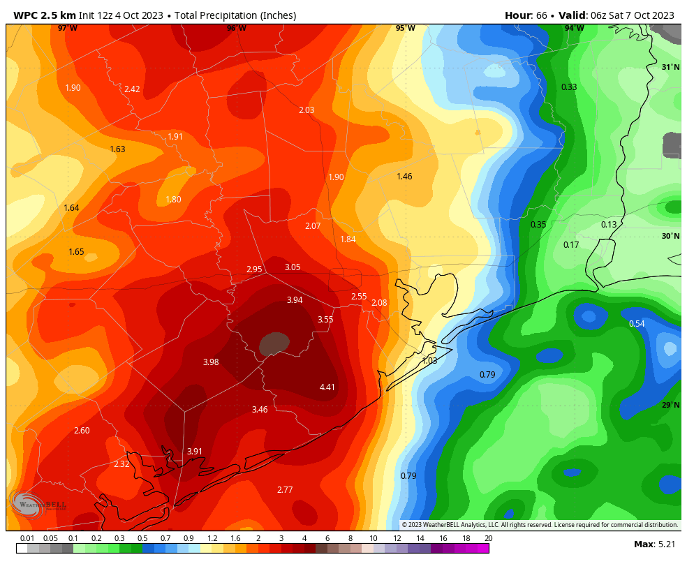
Good morning. Much of the region saw beneficial rains on Tuesday, with widespread accumulations of 0.5 to 1.5 inch. However some areas, particularly in Brazoria County, saw in excess of 6 inches of rainfall. Conditions today will continue to favor the potential for heavy rainfall, particularly to the west of Interstate 45, including the Brazoria, Fort Bend, Wharton, and Matagorda County areas.
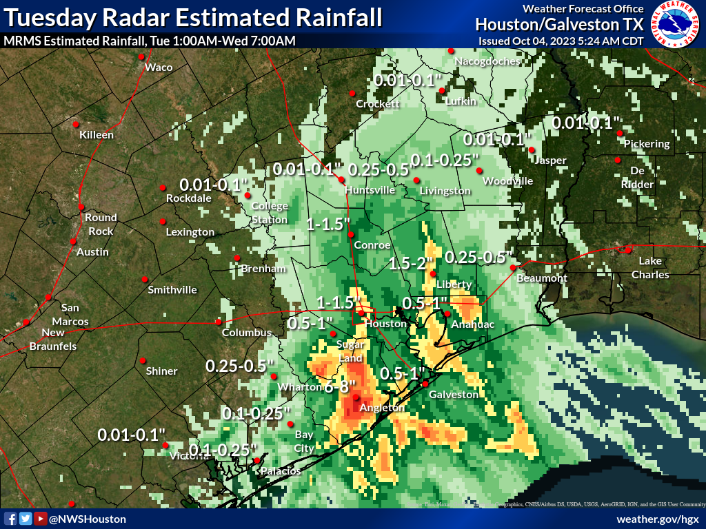
With this in mind, we’re extending our Stage 1 flood alert to the entire Houston metro area, through Thursday evening. In addition we’re raising the flood alert to Stage 2 for Brazoria and Wharton Counties, which lie to the southwest of Houston, and includes the cities of Sugar Land and Angleton. There is the potential for another 3 to 6 inches of rainfall in these areas for the period from now until Thursday night, and this could cause flash flooding. Please continue to be aware of weather and road conditions for the next couple of days.
Wednesday
As noted above, the overall pattern favors the majority of storms forming over the western half of the Houston metro area today, as this will be where a majority of the moisture from the Gulf of Mexico is flowing inland. Look for on and off showers and thunderstorms today, with the potential for some street flooding. High temperatures today will reach the low 80s for most of the area, with mostly cloudy skies, and occasionally gusty winds from the southeast. Rain chances will slacken somewhat overnight, but not go away.
Thursday
A day that looks similar, in terms of overall weather to Wednesday. The difference that instead of the storms moving inland from the Gulf, there will be a more north-to-south movement in association with an advancing front. In any case, we’ll continue the flood alerts through Thursday evening as the potential for heavy rainfall will remain in place. High temperatures will again reach the low- to mid-80s, but with the front’s influence low temperatures will probably drop into the low 70s.
Friday
Rain chances will linger into Friday morning, but after that we should start to see some partially clearing skies. Look for highs in the mid-80s, with overnight lows dropping into the upper 60s. Around this time you may be thinking well, that wasn’t much of a front. Fortunately, a reinforcing front is on the way Friday night and Saturday morning that will truly usher in fall-like conditions.
Saturday and Sunday
Northerly winds should turn fairly gusty by Saturday morning, bringing much drier air into the region. Look for highs in the upper 70s on Saturday, with partly sunny skies. Humidity levels will drop noticeably during the day. Lows on Saturday night will drop into the upper 50s for inland areas, and Sunday looks to be just about perfect. Expect sunny skies, lighter winds, and highs in the mid-70s. We’re officially declaring Sunday to be Fall Day in Houston. (If you’re wondering, yes, we’re trying to organize a Fall Day gathering again this year, but it won’t be this weekend.) Lows on Sunday night will again drop into the 50s for most of the area.
Next week
We’ll see the onshore flow resume by Monday or so, and that should set the stage for warmer days in the mid- to upper-80s for most of the week. There are two things I’m watching for, one of which is a potential surge in tropical moisture during the second half of next week. This would be in association with a tropical system that crosses Mexico from the Pacific Ocean and moves into the Gulf of Mexico. For now the details are fairly vague, and it’s possible that this entire mess remains mostly offshore. Additionally, it looks like another front of some sort should arrive some time next weekend to cool us down and dry out the atmosphere. We’ll see.


Please comment tomorrow on whether we should have clear or cloudy skies for the upcoming eclipse on 10-14
Probably best to wait next week to get a better idea of weather on that day. 9 days is a way off to get accurate data.
I hope this means we are out of drought land and can lift restrictions!
Glad to hear that another Fall Day celebration is being planned – last year’s was pretty awesome at the Houston Botanic Garden even if it was warmer than anticipated.
Having it a few weeks from now will be fine – it will be deeper into the autumn season to solidify its “standing”.
Back on topic: happy to see the rain drops around the area.
Good morning, ABC13 is calling this a Weather Alert Day. I don’t see you reciprocating with your SCW Flood Scale. Do you anticipate excessive rain with possibility of flooding?
They literally said they’re extending the Level 1 potential of flooding to extend to ALL of the Houston Metro area today with Level 2 to be expected SSW of the city.
5″ of rain in the Rosharon area yesterday … only need about 25″ more to catch up!
Only a measly 1-1/2″ in Westchase.
Wow, three months without rain and people have forgotten how to drive in the rain. This is actually typical Houston weather.
There has been enough rain, the yard is full of mosquito ponds, and riding is unpleasant.
I had my fall day a month ago, I am now in the middle of the holiday season.
It’s nice to finally see the end of the tunnel. Without a doubt this was the worst July, Aug, and Sep I’ve experienced here in both heat and dryness, it just seemed to get worse each week with no end in sight. Now several long range models are forecasting wetter fall and winter. Taking into account that Jan-Jun was above normal rainfall, we could still end the year with 40”, which is dryer but not too bad.
Sugar Land is not now nor has it ever been in Brazoria or Wharton Counties, they are in Fort Bend County. If you want our trust you need to get the easy details right.
Sentence seems reasonably clear to me that he is talking about Brazoria County and Wharton County PLUS the 2 cities of Sugar Land and Angleton.
I am wondering if the sentence in question is a geographical error or is kind of awkward grammatically. Maybe what is meant is that Fort Bend County is under a Stage 1 flood alert except for Sugar Land which is under a Stage 2 flood alert.
Do you have any contacts in the Hill Country who can replicate what you’re doing for us in the Houston area? We have a second home there, and I find it nearly impossible to get accurate weather information. I go back and forth from TWC and Accuweather and find their predictions strikingly dissimilar, so what am I to believe? I am grateful for your detailed explanations. You’re the only ones I really trust.
I live on Taylor Lake. Do you know why the tides have been unusually high yesterday and today?
Onshore winds combined with lots of rain will do that.